Liste der Kategorie-A-Bauwerke in Argyll and Bute

Die Liste der Kategorie-A-Gebäude in Argyll and Bute umfasst sämtliche in der Kategorie A eingetragenen Baudenkmäler in der schottischen Council Area Argyll and Bute. Die Einstufung wird anhand der Kriterien von Historic Scotland vorgenommen, wobei in die höchste Kategorie A Bauwerke von nationaler oder internationaler Bedeutung einsortiert sind. Derzeit sind in Argyll and Bute 133 Kategorie-A-Bauwerke ausgewiesen.
| Name | Lage | Typ | Eintrag | Bild |
|---|---|---|---|---|
| Stuckgowan House | Tarbet 56° 11′ 20,8″ N, 4° 42′ 2,5″ W56.189111111111-4.7006944444444 | Landhaus | 861 | |
| St Conan’s Church | Lochawe 56° 23′ 43″ N, 5° 3′ 15″ W56.395277777778-5.0541666666667 | Kirche | 4700 |  |
| Old Breachacha Castle | Insel Coll 56° 35′ 26,9″ N, 6° 37′ 41″ W56.590805555556-6.6280555555556 | Burg | 4708 | 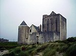 |
| Breachacha Castle | Insel Coll 56° 35′ 30,1″ N, 6° 37′ 46,9″ W56.591694444444-6.6296944444444 | Schloss | 4709 |  |
| Lochnell House | Benderloch 56° 29′ 42,9″ N, 5° 26′ 9,8″ W56.49525-5.4360555555556 | Herrenhaus | 4716 | |
| Lochnell Observatory | nahe Benderloch 56° 29′ 21,8″ N, 5° 26′ 29″ W56.489388888889-5.4413888888889 | Turm | 4717 |  |
| Barcaldine Castle | nahe Benderloch 56° 30′ 37,3″ N, 5° 24′ 4,3″ W56.510361111111-5.4011944444444 | Wohnturm | 4719 | 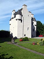 |
| Barbreck House | nahe Ardfern 56° 12′ 2,3″ N, 5° 29′ 54,3″ W56.200638888889-5.4984166666667 | Herrenhaus | 4996 |  |
| St Munn’s Parish Church | Kilmun 55° 59′ 47″ N, 4° 56′ 32,7″ W55.996388888889-4.9424166666667 | Kirche | 5073 |  |
| Dunselma | Strone 55° 59′ 7,3″ N, 4° 53′ 59,1″ W55.985361111111-4.89975 | Villa | 5075 | |
| Goldenes Tor im Benmore Botanic Garden | nahe Dunoon 56° 1′ 19,4″ N, 4° 59′ 23,5″ W56.022055555556-4.9898611111111 | Tor | 6438 | 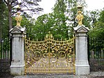 |
| St Peter’s College | Cardross 55° 58′ 13,1″ N, 4° 38′ 26″ W55.970305555556-4.6405555555556 | Priesterseminar | 6464 |  |
| Old Kilmun House | Kilmun 55° 59′ 50,6″ N, 4° 56′ 36,6″ W55.997388888889-4.9435 | Herrenhaus | 6582 | |
| Auchindrain | Auchindrain 56° 10′ 49″ N, 5° 10′ 26,3″ W56.180277777778-5.1739722222222 | historische Ortschaft | 6798 |  |
| Maam Steading | Inveraray 56° 16′ 12,1″ N, 5° 2′ 3,5″ W56.270027777778-5.0343055555556 | Stallung | 11518 | |
| Cherrypark | Inveraray 56° 14′ 14,2″ N, 5° 4′ 41,2″ W56.237277777778-5.0781111111111 | Verwaltungsgebäude | 11528 | |
| Carloonan Doocot | Inveraray 56° 14′ 57,6″ N, 5° 5′ 15,3″ W56.249333333333-5.0875833333333 | Taubenhaus | 11540 | 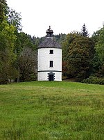 |
| Wachturm von Inveraray Castle | Inveraray 56° 14′ 44,2″ N, 5° 4′ 2,8″ W56.245611111111-5.0674444444444 | Turm | 11543 | 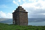 |
| Garden Bridge | Inveraray 56° 14′ 22,8″ N, 5° 4′ 29,8″ W56.239666666667-5.0749444444444 | Brücke | 11544 | 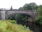 |
| Aray Bridge | Inveraray 56° 14′ 9,3″ N, 5° 4′ 11,9″ W56.235916666667-5.0699722222222 | Brücke | 11545 |  |
| Garron Lodge | Inveraray 56° 14′ 46,2″ N, 5° 2′ 46,9″ W56.246166666667-5.0463611111111 | Wohngebäude | 11548 | |
| Ziermauer der Garron Lodge | Inveraray 56° 14′ 45,9″ N, 5° 2′ 45,9″ W56.246083333333-5.0460833333333 | Mauer | 11549 | |
| Garron Bridge | Inveraray 56° 14′ 45,1″ N, 5° 2′ 43,6″ W56.245861111111-5.0454444444444 | Brücke | 11550 | 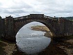 |
| Dubh Loch Bridge | Inveraray 56° 14′ 59,5″ N, 5° 2′ 44,8″ W56.249861111111-5.0457777777778 | Brücke | 11551 | |
| Inveraray Castle | Inveraray 56° 14′ 14,9″ N, 5° 4′ 24,9″ W56.237472222222-5.0735833333333 | Schloss | 11552 | 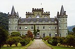 |
| Dunderave Castle | nahe Inveraray 56° 14′ 34,9″ N, 4° 59′ 53″ W56.243027777778-4.9980555555556 | Schloss | 11769 |  |
| Dunans Bridge | im Tal Glendaruel 56° 4′ 25,9″ N, 5° 9′ 0,1″ W56.073861111111-5.1500277777778 | Brücke | 11806 | |
| Sonnenuhr des Ormidale House | im Tal Glendaruel 55° 59′ 11,6″ N, 5° 12′ 16,5″ W55.986555555556-5.2045833333333 | Sonnenuhr | 11810 | |
| Carrick Castle | Carrick 56° 6′ 31,8″ N, 4° 54′ 20,4″ W56.108833333333-4.9056666666667 | Burg | 11815 |  |
| Kilmorich Parish Church | Cairndow 56° 15′ 15,3″ N, 4° 56′ 19″ W56.25425-4.9386111111111 | Kirche | 11818 | 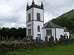 |
| Clachan Bridge | Insel Seil 56° 19′ 3,8″ N, 5° 34′ 58,3″ W56.317722222222-5.5828611111111 | Brücke | 11834 | 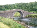 |
| Rhinns of Islay Lighthouse | Insel Orsay 55° 40′ 23″ N, 6° 30′ 47,2″ W55.673055555556-6.5131111111111 | Leuchtturm | 11944 |  |
| Killean Chapel | nahe Tayinloan 55° 38′ 23,7″ N, 5° 39′ 50,2″ W55.639916666667-5.6639444444444 | Kirchenruine | 12004 | |
| Killean House | nahe Tayinloan 55° 38′ 14,4″ N, 5° 39′ 41,2″ W55.637333333333-5.6614444444444 | Herrenhaus | 12005 |  |
| Killean and Kilchenzie Parish Church | nahe Muasdale 55° 36′ 51,7″ N, 5° 41′ 0,8″ W55.614361111111-5.6835555555556 | Kirche | 12035 |  |
| Mount Stuart House | nahe Rothesay 55° 47′ 29,7″ N, 5° 1′ 7,5″ W55.791583333333-5.01875 | Herrenhaus | 12052 |  |
| Mausoleum von Mount Stuart | nahe Rothesay 55° 48′ 4,7″ N, 5° 1′ 0,4″ W55.801305555556-5.0167777777778 | Mausoleum und Friedhof | 12055 | |
| Kerrylamont Farm | Insel Bute 55° 46′ 58,2″ N, 5° 0′ 53,8″ W55.782833333333-5.0149444444444 | Bauernhof | 12056 |  |
| Islay House | Bridgend 55° 47′ 6″ N, 6° 15′ 14″ W55.785-6.2538888888889 | Herrenhaus | 12142 |  |
| Islay Woollen Mill | nahe Bridgend 55° 47′ 22,4″ N, 6° 13′ 29,5″ W55.789555555556-6.2248611111111 | Wollmühle | 12143 | 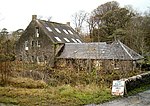 |
| Lorne Furnace | Taynuilt 56° 26′ 13,2″ N, 5° 13′ 47,5″ W56.437-5.2298611111111 | Eisenhütte | 12180 |  |
| Kilarrow Parish Church | Bowmore 55° 45′ 18,3″ N, 6° 17′ 11,3″ W55.755083333333-6.2864722222222 | Kirche | 12184 | 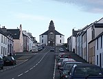 |
| Glenorchy Parish Church | Dalmally 56° 24′ 15″ N, 4° 58′ 16″ W56.404166666667-4.9711111111111 | Kirche | 12192 | 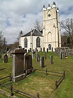 |
| Iona Abbey | Insel Iona 56° 20′ 6,5″ N, 6° 23′ 29,4″ W56.335138888889-6.3915 | Kloster | 12310 | 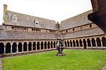 |
| Dubh Artach Lighthouse | Insel Dubh Artach 56° 7′ 59,3″ N, 6° 37′ 57,8″ W56.133138888889-6.6327222222222 | Leuchtturm | 12320 |  |
| Castle Stalker | Insel in Loch Linnhe 56° 34′ 17,7″ N, 5° 23′ 9,9″ W56.571583333333-5.3860833333333 | Burgruine | 12345 |  |
| Lismore Lighthouse | Insel Eilean Musdile 56° 27′ 20″ N, 5° 36′ 26,6″ W56.455555555556-5.6073888888889 | Leuchtturm | 12360 |  |
| Airds House | Port Appin 56° 33′ 1″ N, 5° 24′ 10,1″ W56.550277777778-5.4028055555556 | Herrenhaus | 12363 | 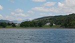 |
| Islandadd Bridge | Bellanoch 56° 4′ 28,5″ N, 5° 31′ 43,6″ W56.074583333333-5.5287777777778 | Brücke | 13042 | 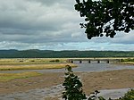 |
| Ardkinglas House | Cairndow 56° 15′ 3″ N, 4° 56′ 49,3″ W56.250833333333-4.9470277777778 | Herrenhaus | 13786 |  |
| Rossdhu House | nahe Luss 56° 4′ 13″ N, 4° 37′ 59,5″ W56.070277777778-4.6331944444444 | Herrenhaus | 14469 |  |
| Hynish Harbour | Insel Tiree 56° 26′ 55,9″ N, 6° 53′ 33,9″ W56.448861111111-6.89275 | Hafenanlage | 17848 |  |
| Skerryvore Lighthouse | Insel Skerryvore 56° 19′ 23,2″ N, 7° 6′ 58,5″ W56.323111111111-7.11625 | Leuchtturm | 17849 | 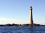 |
| 3 Kilmoluaig | Kilmoluaig 56° 30′ 20″ N, 6° 55′ 45″ W56.505555555556-6.9291666666667 | Wohngebäude | 17857 | |
| 13 Kilmoluaig | Kilmoluaig 56° 30′ 32,7″ N, 6° 55′ 30,5″ W56.509083333333-6.9251388888889 | Wohngebäude | 17859 | |
| Torosay Castle, 19 Statuen | nahe Lochdon 56° 27′ 15,6″ N, 5° 41′ 15″ W56.454333333333-5.6875 | Statuen | 17929 | 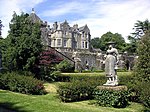 |
| Macquarrie-Mausoleum | Mull 56° 29′ 12″ N, 5° 58′ 55,6″ W56.486666666667-5.9821111111111 | Mausoleum | 17942 |  |
| Duart Castle | nahe Lochdon 56° 27′ 22″ N, 5° 39′ 18,2″ W56.456111111111-5.6550555555556 | Schloss | 17974 | 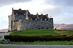 |
| Torosay Castle | nahe Lochdon 56° 27′ 17,8″ N, 5° 41′ 13,7″ W56.454944444444-5.6871388888889 | Schloss | 17975 | 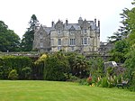 |
| Wester Kames Castle | nahe Port Bannatyne 55° 52′ 0″ N, 5° 5′ 57,4″ W55.866666666667-5.0992777777778 | Schloss | 18287 | |
| Stewart Hall | nahe Rothesay 55° 49′ 7,8″ N, 5° 6′ 21″ W55.818833333333-5.1058333333333 | Herrenhaus | 18289 | |
| Cour House | Halbinsel Kintyre 55° 40′ 40,4″ N, 5° 27′ 48,4″ W55.677888888889-5.4634444444444 | Landhaus | 18360 | |
| Saddell Castle | Saddell 55° 31′ 38,9″ N, 5° 30′ 16,7″ W55.527472222222-5.5046388888889 | Burg | 18403 | 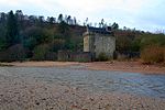 |
| Ardencaple Hotel | Rhu 56° 0′ 47,2″ N, 4° 45′ 51,9″ W56.013111111111-4.7644166666667 | Hotel | 19525 |  |
| Torbogen von Rossdhu | nahe Luss 56° 2′ 45,8″ N, 4° 38′ 44,9″ W56.046055555556-4.6458055555556 | Torbogen | 19698 | 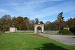 |
| Mull of Kintyre Lighthouse | Mull of Kintyre 55° 18′ 37,5″ N, 5° 48′ 11,7″ W55.310416666667-5.80325 | Leuchtturm | 19874 |  |
| Bellgrove | Campbeltown 55° 25′ 45″ N, 5° 35′ 23,1″ W55.429166666667-5.58975 | Villa | 22940 | |
| Rothmar | Campbeltown 55° 25′ 44,3″ N, 5° 35′ 34,7″ W55.428972222222-5.5929722222222 | Villa | 22941 | |
| Campbeltown Library and Museum | Campbeltown 55° 25′ 25,8″ N, 5° 36′ 10,1″ W55.423833333333-5.6028055555556 | Museum | 22964 |  |
| Picture House | Campbeltown 55° 25′ 26,3″ N, 5° 36′ 11,1″ W55.423972222222-5.6030833333333 | Kino | 22965 |  |
| St John’s Church | Dunoon 55° 57′ 2,3″ N, 4° 55′ 43,3″ W55.950638888889-4.9286944444444 | Kirche | 26440 | 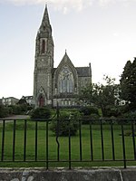 |
| Pier von Dunoon | Dunoon 55° 56′ 48,1″ N, 4° 55′ 16,8″ W55.946694444444-4.9213333333333 | Pier | 26450 |  |
| Rockland | Helensburgh 55° 59′ 54″ N, 4° 43′ 4,7″ W55.998333333333-4.7179722222222 | Villa | 34737 | |
| Hill House | Helensburgh 56° 1′ 1,1″ N, 4° 43′ 40,9″ W56.016972222222-4.7280277777778 | Villa | 34761 | 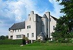 |
| White House | Helensburgh 56° 0′ 54,4″ N, 4° 43′ 49,8″ W56.015111111111-4.7305 | Villa | 34762 |  |
| Drumadoon | Helensburgh 56° 1′ 2,7″ N, 4° 43′ 46,1″ W56.017416666667-4.7294722222222 | Villa | 34763 | |
| Greycourt | Helensburgh 56° 0′ 58,9″ N, 4° 43′ 44,6″ W56.016361111111-4.7290555555556 | Villa | 34771 | |
| Red Towers | Helensburgh 56° 0′ 53,1″ N, 4° 43′ 44,7″ W56.01475-4.7290833333333 | Villa | 34774 | |
| Brantwoode | Helensburgh 56° 0′ 46,6″ N, 4° 43′ 47,2″ W56.012944444444-4.7297777777778 | Villa | 34822 | 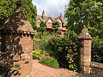 |
| Cairndhu House | Helensburgh 56° 0′ 23,4″ N, 4° 45′ 11,5″ W56.0065-4.7531944444444 | Villa | 34847 |  |
| Dalmore House | Helensburgh 56° 0′ 40,6″ N, 4° 45′ 33,5″ W56.011277777778-4.7593055555556 | Herrenhaus | 34849 | |
| Longcroft | Helensburgh 56° 0′ 46,9″ N, 4° 44′ 9,7″ W56.013027777778-4.7360277777778 | Villa | 34851 | |
| 38–40 Sinclair Street | Helensburgh 56° 0′ 12,9″ N, 4° 43′ 59,3″ W56.003583333333-4.7331388888889 | Wohngebäude | 34868 | 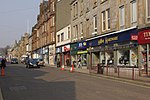 |
| Kriegsdenkmal von Helensburgh | Helensburgh 56° 0′ 29,7″ N, 4° 43′ 41,6″ W56.00825-4.7282222222222 | Denkmal | 34872 |  |
| St Michael and All Angels’ Church | Helensburgh 56° 0′ 17,6″ N, 4° 44′ 25,1″ W56.004888888889-4.7403055555556 | Kirche | 34896 |  |
| Inveraray Parish Church | Inveraray 56° 13′ 48,6″ N, 5° 4′ 24,1″ W56.230166666667-5.0733611111111 | Kirche | 34978 |  |
| Morrison’s Land | Inveraray 56° 13′ 50,2″ N, 5° 4′ 23,5″ W56.230611111111-5.0731944444444 | Wohn- und Geschäftshaus | 34981 |  |
| George Hotel | Inveraray 56° 13′ 49,6″ N, 5° 4′ 22,3″ W56.230444444444-5.0728611111111 | Hotel | 34995 |  |
| Relief Land | Inveraray 56° 13′ 46,7″ N, 5° 4′ 24,9″ W56.229638888889-5.0735833333333 | Wohngebäude | 34999 |  |
| Mackenzie’s Land | Inveraray 56° 13′ 45,6″ N, 5° 4′ 27,7″ W56.229333333333-5.0743611111111 | Wohngebäude | 35000 | |
| Black’s Land | Inveraray 56° 13′ 46″ N, 5° 4′ 27,2″ W56.229444444444-5.0742222222222 | Wohngebäude | 35001 | |
| Arkland | Inveraray 56° 13′ 47,1″ N, 5° 4′ 26,3″ W56.22975-5.0739722222222 | Wohngebäude | 35002 | 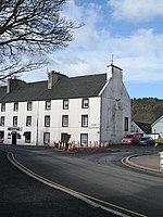 |
| Altes Pfarrhaus von Inveraray | Inveraray 56° 13′ 52″ N, 5° 4′ 18,5″ W56.231111111111-5.0718055555556 | Pfarrhaus | 35003 |  |
| Gillies’ House | Inveraray 56° 13′ 52,2″ N, 5° 4′ 19,1″ W56.231166666667-5.0719722222222 | Geschäfts- und Wohngebäude | 35004 | |
| Temperance Hotel | Inveraray 56° 13′ 52,4″ N, 5° 4′ 19,7″ W56.231222222222-5.0721388888889 | Wohngebäude | 35005 | |
| Chamberlain’s House | Inveraray 56° 13′ 52,8″ N, 5° 4′ 21,3″ W56.231333333333-5.0725833333333 | Wohngebäude | 35006 |  |
| Town House | Inveraray 56° 13′ 53,1″ N, 5° 4′ 22,3″ W56.231416666667-5.0728611111111 | Verwaltungsgebäude | 35007 | |
| Ivy House | Inveraray 56° 13′ 53,3″ N, 5° 4′ 23″ W56.231472222222-5.0730555555556 | Wohngebäude | 35008 | |
| Ziermauer von Inveraray | Inveraray 56° 13′ 53,6″ N, 5° 4′ 24″ W56.231555555556-5.0733333333333 | Torbogen | 35009 |  |
| The Great Inn | Inveraray 56° 13′ 54,1″ N, 5° 4′ 26,1″ W56.231694444444-5.0739166666667 | Hotel | 35011 | 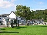 |
| Torbogen von Inveraray | Inveraray 56° 13′ 54,4″ N, 5° 4′ 27,1″ W56.231777777778-5.0741944444444 | Torbogen | 35013 |  |
| Duke’s Tower | Inveraray 56° 13′ 49,5″ N, 5° 4′ 31,8″ W56.230416666667-5.0755 | Kirchturm | 35019 |  |
| Gerichtsgebäude von Inveraray | Inveraray 56° 13′ 47,6″ N, 5° 4′ 20,3″ W56.229888888889-5.0723055555556 | Gerichtsgebäude und Gefängnis | 35030 |  |
| Gefängnismauer von Inveraray | Inveraray 56° 13′ 47,2″ N, 5° 4′ 19,1″ W56.229777777778-5.0719722222222 | Gefängnismauer | 35032 | 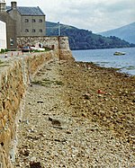 |
| Factory Land | Inveraray 56° 13′ 48,9″ N, 5° 4′ 19″ W56.23025-5.0719444444444 | Wohngebäude | 35037 | |
| Ferry Land | Inveraray 56° 13′ 49,2″ N, 5° 4′ 18,8″ W56.230333333333-5.0718888888889 | Wohngebäude | 35038 | |
| Fern Point | Inveraray 56° 13′ 49,9″ N, 5° 4′ 19,4″ W56.230527777778-5.0720555555556 | Wohngebäude | 35039 | |
| St Columba’s Cathedral | Oban 56° 25′ 9,9″ N, 5° 28′ 43,9″ W56.419416666667-5.4788611111111 | Kirche | 38820 | 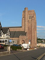 |
| High Kirk Mausoleum | Rothesay 55° 49′ 43,2″ N, 5° 3′ 27,9″ W55.828666666667-5.05775 | Mausoleum | 40446 |  |
| Bedürfnisanstalt von Rothesay | Rothesay 55° 50′ 19,3″ N, 5° 3′ 16″ W55.838694444444-5.0544444444444 | Bedürfnisanstalt | 40448 | 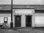 |
| St Andrew’s Roman Catholic Church | Rothesay 55° 50′ 10,7″ N, 5° 3′ 30,5″ W55.836305555556-5.0584722222222 | Kirche | 40451 | |
| Rothesay Pavilion | Rothesay 55° 50′ 26,7″ N, 5° 3′ 43,5″ W55.84075-5.0620833333333 | Veranstaltungsgebäude | 40452 |  |
| Winter Gardens | Rothesay 55° 50′ 18″ N, 5° 3′ 20,4″ W55.838333333333-5.0556666666667 | Veranstaltungsgebäude | 40454 |  |
| Bute Estate Office | Rothesay 55° 50′ 9,5″ N, 5° 3′ 14,4″ W55.835972222222-5.054 | Verwaltungsgebäude | 40456 | 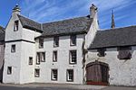 |
| Tor House | Rothesay 55° 50′ 27,7″ N, 5° 1′ 37,1″ W55.841027777778-5.0269722222222 | Villa | 40468 | |
| Gareloch House | Clynder 56° 0′ 51″ N, 4° 48′ 31,1″ W56.014166666667-4.8086388888889 | Villa | 42621 | |
| Badehaus von Rosneath Castle | nahe Rosneath 55° 59′ 56″ N, 4° 47′ 6,7″ W55.998888888889-4.7851944444444 | Badehaus | 42625 | |
| Rosneath Home Farm | nahe Rosneath 55° 59′ 39,1″ N, 4° 46′ 56,2″ W55.994194444444-4.7822777777778 | Bauernhof | 42628 | 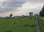 |
| Ferry Inn | Rosneath 56° 0′ 43,1″ N, 4° 47′ 46″ W56.011972222222-4.7961111111111 | Villa | 42630 | |
| St Modan’s Parish Church (Rosneath) | nahe Rosneath 56° 0′ 34,2″ N, 4° 48′ 4,9″ W56.0095-4.8013611111111 | Kirche | 42634 | 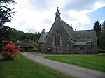 |
| St Mahew’s Chapel | nahe Cardross 55° 58′ 19,2″ N, 4° 39′ 29,7″ W55.972-4.65825 | Kirche | 42905 | 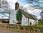 |
| Redholme | Campbeltown 55° 25′ 10,1″ N, 5° 35′ 52″ W55.419472222222-5.5977777777778 | Villa | 43088 | |
| Sloy Power Station | Loch Lomond 56° 15′ 4,4″ N, 4° 42′ 41,7″ W56.251222222222-4.7115833333333 | Wasserkraftwerk | 43188 | 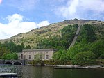 |
| Doll’s Houses | nahe Tayinloan 55° 38′ 27″ N, 5° 39′ 46,8″ W55.640833333333-5.663 | Landhäuser | 43266 | 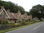 |
| Glen Eden | Kilcreggan 55° 59′ 21,2″ N, 4° 50′ 59,4″ W55.989222222222-4.8498333333333 | Villa | 43442 | |
| Knockderry Castle | Cove 56° 0′ 37,3″ N, 4° 51′ 41,9″ W56.010361111111-4.8616388888889 | Schloss | 43452 |  |
| Craig Ailey | Cove 55° 59′ 31,9″ N, 4° 51′ 6,9″ W55.992194444444-4.8519166666667 | Villa | 43472 | |
| Auchendennan House | Arden 56° 0′ 59,3″ N, 4° 37′ 8,4″ W56.016472222222-4.619 | Schloss | 43871 | 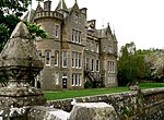 |
| Darleith Dovecot | nahe Cardross 55° 59′ 22,6″ N, 4° 39′ 8,3″ W55.989611111111-4.6523055555556 | Taubenturm | 43874 | 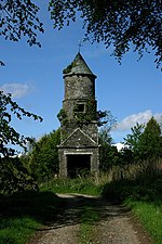 |
| Balmory House | Ascog 55° 49′ 16,3″ N, 5° 1′ 41,4″ W55.821194444444-5.0281666666667 | Villa | 44984 | |
| Holzkohlelager in Furnace | Furnace 56° 9′ 9,4″ N, 5° 10′ 46,6″ W56.152611111111-5.1796111111111 | Lagergebäude | 49844 | |
| Falls of Cruachan Railway Viaduct | nahe Lochawe 56° 23′ 40,1″ N, 5° 6′ 50,9″ W56.394472222222-5.1141388888889 | Brücke | 50811 | 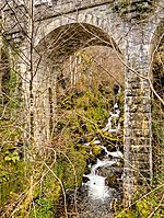 |
| Turbinenhalle der Cruachan Power Station | nahe Lochawe 56° 24′ 10,2″ N, 5° 6′ 46,4″ W56.402833333333-5.1128888888889 | Industriebauwerk | 51688 |
Weblinks
Commons: Kategorie-A-Bauwerke in Argyll and Bute – Sammlung von Bildern, Videos und Audiodateien
- Datenbank für Baudenkmäler von Historic Scotland
- Karte mit allen Koordinaten:
- OSM
- WikiMap

Listen der Kategorie-A-Bauwerke in Schottland
Council areas:
Aberdeen | Aberdeenshire | Angus | Argyll and Bute | Äußere Hebriden | Clackmannanshire | Dumfries and Galloway | Dundee | East Ayrshire | East Dunbartonshire | East Lothian | East Renfrewshire | Edinburgh – Old Town – New Town | Falkirk | Fife | Glasgow | Highland | Inverclyde | Midlothian | Moray | North Ayrshire | North Lanarkshire | Orkney | Perth and Kinross | Renfrewshire | Scottish Borders | Shetland | South Ayrshire | South Lanarkshire | Stirling | West Dunbartonshire | West Lothian


