Alderley, Wisconsin
Unincorporated community in Wisconsin, United States
Alderley, Wisconsin | |
|---|---|
Unincorporated community | |
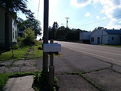 County Road O is the primary and sole modern-day thoroughfare for the small hamlet. | |
43°13′03″N 88°26′59″W / 43.21750°N 88.44972°W / 43.21750; -88.44972 | |
| Country |  United States United States |
| State |  Wisconsin Wisconsin |
| County | Dodge County |
| Town | Ashippun |
| Elevation [1] | 290 m (951 ft) |
| Time zone | UTC-6 (Central (CST)) |
| • Summer (DST) | UTC-5 (CDT) |
| Area code | 920 |
| GNIS feature ID | 1560746[1] |
Alderley is an unincorporated community located in the town of Ashippun, Dodge County, Wisconsin, United States.[1][2] Alderley is located on Highway O approximately 7 miles (11 km) north of Stone Bank, 3 miles (5 km) north of the unincorporated community of Mapleton, and 3 miles (5 km) east of Ashippun. The community was named by early settlers for Alderley Edge, England.[3]
Notes
- v
- t
- e
Municipalities and communities of Dodge County, Wisconsin, United States
County seat: Juneau

- Ashippun
- Burnett
- Lebanon
- Rubicon
communities
- Alderley
- Astico
- Atwater
- Beaver Edge
- Clyman Junction
- Danville
- Delbern Acres
- East Waupun
- Farmersville
- Fox Lake Junction
- Herman Center
- Hochheim
- Huilsburg
- Knowles
- Leipsig
- LeRoy
- Lost Lake
- Lyndon Dale
- Minnesota Junction
- Nasbro
- Neda
- North Lowell
- Oak Grove
- Old Ashippun
- Old Lebanon
- Portland‡
- Richwood
- Rolling Prairie
- Saylesville
- South Beaver Dam
- South Randolph
- Sugar Island
- Sunset Beach
- Theresa Station
- Woodland
‡This populated place also has portions in an adjacent county or counties
- Wisconsin portal
- United States portal
 | This article about a location in Dodge County, Wisconsin is a stub. You can help Wikipedia by expanding it. |
- v
- t
- e


