Blue Bell Hill (village)
Human settlement in England
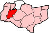
- Aylesford
- Tonbridge and Malling
- Kent
- South East
- Chatham and Aylesford
Blue Bell Hill is a village in the Aylesford parish of the borough of Tonbridge and Malling in Kent, England. It is located halfway between Chatham and Maidstone and lies on top of Blue Bell Hill. The community significantly expanded with the developments of the Walderslade area in the post war years, creating several housing estates around the village.
Transport
The village is located to the south of the intersection (junction 3) of the M2 and A229 and is bypassed by the A229. The A229 traces the route of a Roman road between Chatham and Maidstone, and its old route up the hill still exists (Warren Road).
There are extensive regular bus services between the Medway Towns and Maidstone by Arriva, historically Maidstone & District (the 101 and 150 routes) as well as local Bus 142 into Medway There are also numerous commuter coaches travelling into London.
Local government
Blue Bell Hill and parts of southern Walderslade are located in the Aylesford parish of Tonbridge and Malling. The rest of Walderslade is in the borough of Medway.
See also
External links
![]() Media related to Blue Bell Hill (village) at Wikimedia Commons
Media related to Blue Bell Hill (village) at Wikimedia Commons
- v
- t
- e
- Addington
- Aylesford
- Branbridges
- Beltring
- Birling
- Blue Bell Hill
- Borough Green
- Burham
- Ditton
- East Malling
- East Peckham
- Eccles
- Golden Green
- Hadlow
- Hildenborough
- Ightham
- Kings Hill
- Larkfield
- Leybourne
- Mereworth
- New Hythe
- Offham
- Platt (St. Mary's Platt)
- Plaxtol
- Ryarsh
- Shipbourne
- Snodland
- Stansted
- Tonbridge
- Trottiscliffe
- Walderslade
- Wateringbury
- West Malling
- West Peckham
- Wouldham
- Wrotham
- Wrotham Heath
 | This Kent location article is a stub. You can help Wikipedia by expanding it. |
- v
- t
- e


