Chok-Tal
Place in Issyk-Kul Region, Kyrgyzstan
Chok-Tal Чок-Тал | |
|---|---|
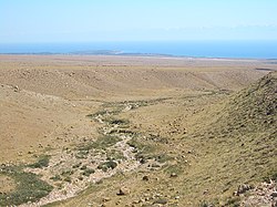 Looking toward Chok-Tal (on the peninsula) and Tamchy airport (to the right of it) from the plain above Tamchy | |
| 42°34′48″N 76°44′24″E / 42.58000°N 76.74000°E / 42.58000; 76.74000 | |
| Country | Kyrgyzstan |
| Region | Issyk-Kul Region |
| District | Issyk-Kul District |
| Elevation | 1,625 m (5,331 ft) |
| Population (2023) | |
| • Total | 2,009 |
| Time zone | UTC+6 |
Chok-Tal (Kyrgyz: Чок-Тал) is a village in the Issyk-Kul District of the Issyk-Kul Region of Kyrgyzstan.[1] Its population was 1,910 in 2021.[2] It is located on the northern shore of Lake Issyk Kul between Tamchy and Cholpon Ata.
References
- ^ "Classification system of territorial units of the Kyrgyz Republic" (in Kyrgyz). National Statistics Committee of the Kyrgyz Republic. May 2021. pp. 12–14.
- ^ "Population of regions, districts, towns, urban-type settlements, rural communities and villages of Kyrgyz Republic" (XLS) (in Russian). National Statistics Committee of the Kyrgyz Republic. 2021. Archived from the original on 10 November 2021.
- v
- t
- e
Populated places in Issyk-Kul District, Issyk-Kul Region
Seat: Cholpon-Ata
- Cholpon-Ata
- Anan'yevo
- Bosteri
- Chok-Tal
- Chong-Örüktü
- Chong-Sary-Oy
- Chyrpykty
- Grigor'yevka
- Jarkynbaev
- Kara-Oy
- Karool-Döbö
- Kojoyar
- Kök-Döbö
- Korumdu
- Kosh-Köl
- Örnök
- Orto-Örüktü
- Örüktü-Khutor
- Sary-Kamysh
- Semyonovka
- Tamchy
- Temir
- Toru-Aygyr
 | This Issyk-Kul region location article is a stub. You can help Wikipedia by expanding it. |
- v
- t
- e


 Chok-Tal