Coachella Canal
Aqueduct in California, US
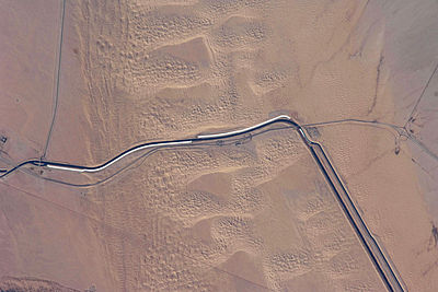
The Coachella Canal is a 122-mile (196 km) aqueduct that conveys Colorado River water for irrigation northwest from the All-American Canal to the Coachella Valley north of the Salton Sea in Riverside County, California.
The canal was completed in 1949 and is currently operated by the Coachella Valley Water District.
Construction of the Coachella Canal began in the 1930s by the Six Companies, Inc., but was interrupted by World War II. After the war, work was resumed on the canal and deliveries of water began in the late 1940s.[1]
The canal was mostly earth-lined when it was first constructed, except for the last 38 miles, which were concrete-lined. Today, most of the canal is lined with concrete to prevent water loss from seepage. Grass eating fish are stocked in the canal to prevent water loss to aquatic vegetation. [2]
See also
- All-American Canal
- All-American Canal Bridge
- Alamo Canal
- Imperial Irrigation District
- Imperial Land Company
- California Development Company
- Imperial Valley
References
- ^ "Coachella Valley Water District - Water and the Coachella Valley". Cvwd.org. Archived from the original on 2008-01-21. Retrieved 2011-05-28.
- ^ "Water and the Coachella Valley" (PDF). growingcoachellavalley.org. February 19, 2020. Archived (PDF) from the original on February 19, 2020. Retrieved February 19, 2020.
External links
- U.S. Geological Survey Geographic Names Information System: Coachella Canal
- Coachella Valley Water District-Water and the Coachella Valley
33°20′09″N 115°33′05″W / 33.33583°N 115.55139°W / 33.33583; -115.55139
- v
- t
- e
Colorado River system
- United States
- Arizona
- California
- Colorado
- Nevada
- New Mexico
- Utah
- Wyoming
- Mexico


- Byers Canyon
- Gore Canyon
- Red Gorge
- Glenwood Canyon
- De Beque Canyon
- Horsethief Canyon
- Ruby Canyon
- Westwater Canyon
- Cataract Canyon
- Narrow Canyon
- Glen Canyon
- Grand Canyon
- Marble Canyon
- Granite Gorge
- Middle Granite Gorge
- Lower Granite Gorge
- Grand Wash Canyon
- Iceberg Canyon
- Virgin Canyon
- Boulder Canyon
- Black Canyon
- Pyramid Canyon
- Mohave Canyon
- River course
- Rocky Mountains
- Colorado River Basin
- Colorado Plateau
- Grand Lake
- Horseshoe Bend
- Sonoran Desert
- Mojave Desert
- Lower Colorado River Valley
- Mohave Valley
- Parker Valley
- Palo Verde Valley
- Colorado Desert
- Alamo River
- New River
- Salton Sea
- Imperial Valley
- Delta
- Montague Island
- Gulf of California/Sea of Cortez
- Blue River
- Dirty Devil River
- Dolores River
- Escalante River
- Eagle River
- Fraser River
- Gila River
- Green River
- Gunnison River
- Kanab Creek
- Little Colorado River
- Paria River
- Roaring Fork River
- San Juan River
- Thunder River/Tapeats Creek
- Virgin River
- Las Vegas Wash
- Williams Fork
- Río Hardy
| Mainstem dams |
|
|---|---|
| Major reservoirs | |
| Aqueducts and canals | |
| Water projects |
 | This article about a California building or structure is a stub. You can help Wikipedia by expanding it. |
- v
- t
- e


