Crescent Street station (BMT Jamaica Line)
New York City Subway station in Brooklyn
New York City Subway station in Brooklyn, New York
J  (all times)
 Z
 (rush hours, peak direction)
 NYCT Bus: B13
direction
transfer
 1.5%
1.5%| Services | ||||||||||||||||
|---|---|---|---|---|---|---|---|---|---|---|---|---|---|---|---|---|
| ||||||||||||||||
| Location |
|---|
    |
| Track layout | ||||||||||||||||||||||||||||||||||||||||||||||||||||||||||||||||||||||||||||||||||||||||||||||||||||
|---|---|---|---|---|---|---|---|---|---|---|---|---|---|---|---|---|---|---|---|---|---|---|---|---|---|---|---|---|---|---|---|---|---|---|---|---|---|---|---|---|---|---|---|---|---|---|---|---|---|---|---|---|---|---|---|---|---|---|---|---|---|---|---|---|---|---|---|---|---|---|---|---|---|---|---|---|---|---|---|---|---|---|---|---|---|---|---|---|---|---|---|---|---|---|---|---|---|---|---|---|
|
| ||||||||||||||||||||||||||||||||||||||||||||||||||||||||||||||||||||||||||||||||||||||||||||||||||||


| Street map |
|---|
|
|

| Station service legend | |
|---|---|
| Symbol | Description |
 | Stops all times except rush hours in the peak direction |
| Stops rush hours in the peak direction only |
| Stops all times |
The Crescent Street station is a station on the BMT Jamaica Line of the New York City Subway. Located at the intersection of Crescent and Fulton Streets in Cypress Hills, Brooklyn, it is served by the J train at all times and the Z during rush hours in the peak direction.
History
This station was opened on May 30, 1893 as part of the Brooklyn Elevated Railroad's four stop extension of the Lexington Avenue Line to Cypress Hills.[2]
Joint service with the Long Island Rail Road's Atlantic Branch existed between Norwood Avenue and Crescent Street stations with a connection built at Chestnut Street in Brooklyn. This allowed BRT trains to access the Rockaways and Manhattan Beach while affording the LIRR a connection into Manhattan to the BRT terminal located at Park Row over the Brooklyn Bridge (this service predated the opening of the East River Tunnels to Penn Station). This service ended in 1917 when the United States Railroad Administration took over the LIRR, and classified different operating standards between rapid transit trains and regular heavy rail railroads such as the LIRR.[4]: 59 The ramp was taken down in 1942 for World War II scrap. A tower continued to stand west of the station to control trains using the incline until it was taken down sometime after 1970.
This station was renovated in 2007. As part of the station renovation project, the stairs were rehabilitated, the floors were renewed, major structural repairs were made, new canopies were installed, the area around the station booth was reconfigured, the platform edge strips were replaced, walls were replaced, and a high-quality public address system was installed.[5] The renovation cost $8.43 million.[6] In 2023, a short barrier was installed at the center of the platforms to reduce the probability of passengers being pushed into the tracks.[7]
Station layout
| 2nd floor | Westbound | ←  toward Broad Street (Cleveland Street AM rush, Norwood Avenue other times) toward Broad Street (Cleveland Street AM rush, Norwood Avenue other times)←  AM rush toward Broad Street (Norwood Avenue) AM rush toward Broad Street (Norwood Avenue) |
| Island platform | ||
| Eastbound | → toward Jamaica Center–Parsons/Archer (Cypress Hills) → → PM rush toward Jamaica Center–Parsons/Archer (75th Street–Elderts Lane) → | |
| Mezzanine | Fare control, station agent, MetroCard machines | |
| Ground | Street level | Exit / entrance |
This elevated station has two tracks and one narrow island platform. An arched canopy covers the eastern half (railroad north) of the platform.
An artwork called Wheel of Bloom – Soak Up the Sun by Jung Hyang Kim was installed in this station during a 2007 renovation. It consists of stained glass panels on the platform's sign structures showing subway train wheels lit by sunlight.
A sharp S Curve moves the line from Fulton Street to Jamaica Avenue immediately north of the station. The first turn, from Fulton Street onto Crescent Street, ranks as the sharpest curve in the B Division, and second sharpest in the entire New York City Subway, second only to City Hall on the IRT Lexington Avenue Line.[8] From the late-1950s into the 1960s the New York City Transit Authority had a proposal to realign the BMT Jamaica Line from this station (actually from Grant or Nichols Avenues) northeast to 80th Street and Jamaica Avenue, west of the 85th Street station. This would have also included an express track. The realignment was never carried out.[9]
Exits
The station's small, single station house is on the extreme eastern end of the platform. It has a turnstile bank, token booth, and a single staircase going to an overpass below the tracks that splits into two staircases going down to either side of Fulton Street between Crescent and Pine Streets.[10]
Gallery
-
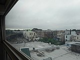 The station as seen from the "S-curve"
 -
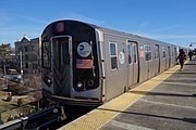 Southbound J train arriving


References
- ^ "Glossary". Second Avenue Subway Supplemental Draft Environmental Impact Statement (SDEIS) (PDF). Vol. 1. Metropolitan Transportation Authority. March 4, 2003. pp. 1–2. Archived from the original (PDF) on February 26, 2021. Retrieved January 1, 2021.
- ^ a b "Trains Running This Morning The Elevated Road to Cypress Hills Still in Operation". The Brooklyn Daily Eagle. May 30, 1893. p. 10. Retrieved October 2, 2016 – via Brooklyn Newspapers.
- ^ a b "Annual Subway Ridership (2018–2023)". Metropolitan Transportation Authority. 2023. Retrieved April 20, 2024.
- ^ ERA Headlights. Electric Railroaders Association. 1956.
- ^ "MTA NYC Transit Subway Line Information". mta.info. Metropolitan Transportation Authority. December 21, 2005. Archived from the original on December 21, 2005. Retrieved October 2, 2016.
{{cite web}}: CS1 maint: bot: original URL status unknown (link) - ^ MTA 2006 Adopted Budget - February Financial Plan - Part 3 (PDF) (Report). Metropolitan Transportation Authority. 2006. p. 46. Archived from the original (PDF) on May 24, 2019. Retrieved March 27, 2020.
- ^ Mocker, Greg (October 27, 2023). "MTA testing new safety measures on subway platforms". PIX11. Retrieved January 21, 2024.
- ^ "NYC Minimum Curve Radius". Web Archive. Archived from the original on May 13, 2006. Retrieved July 5, 2017.
- ^ "Woodhavenites Fear Loss of Homes by El Improvement: Residents Clamor for Facts About City's Plan to Build El Structure Through Heart of Community; Official Statement Released by Transit Authority". The Leader–Observer. October 2, 1958. Retrieved July 27, 2016 – via Fulton History.
- ^ "MTA Neighborhood Maps: East New York" (PDF). mta.info. Metropolitan Transportation Authority. 2015. Retrieved July 19, 2015.
External links
Wikimedia Commons has media related to Crescent Street (BMT Jamaica Line).
- nycsubway.org – BMT Jamaica Line: Crescent Street
- Station Reporter — J Train
- The Subway Nut — Crescent Street Pictures
- MTA's Arts For Transit — Crescent Street (BMT Jamaica Line)
- Crescent Street entrance from Google Maps Street View
- Platform from Google Maps Street View
- v
- t
- e
Nassau Street Local- Jamaica Center–Parsons/Archer
- Sutphin Boulevard–Archer Avenue–JFK Airport
- 121st Street
- 111th Street
- 104th Street
- Woodhaven Boulevard
- 85th Street–Forest Parkway
- 75th Street–Elderts Lane
- Cypress Hills
- Crescent Street
- Norwood Avenue
- Cleveland Street
- Van Siclen Avenue
- Alabama Avenue
- Broadway Junction
- Chauncey Street
- Halsey Street
- Gates Avenue
- Kosciuszko Street
- Myrtle Avenue
- Flushing Avenue
- Lorimer Street
- Hewes Street
- Marcy Avenue
- Essex Street
- Bowery
- Canal Street
- Chambers Street
- Fulton Street
- Broad Street
Nassau Street Express- Jamaica Center–Parsons/Archer
- Sutphin Boulevard–Archer Avenue–JFK Airport
- 121st Street
- 104th Street
- Woodhaven Boulevard
- 75th Street–Elderts Lane
- Crescent Street
- Norwood Avenue
- Van Siclen Avenue
- Alabama Avenue
- Broadway Junction
- Chauncey Street
- Gates Avenue
- Myrtle Avenue
- Marcy Avenue
- Essex Street
- Bowery
- Canal Street
- Chambers Street
- Fulton Street
- Broad Street
- See also
- Lists by borough (The Bronx
- Brooklyn
- Manhattan
- Queens)
- Accessible
- Closed
- Terminals
- Transfer
- Commons category
- Note: Service variations, station closures, and reroutes are not reflected here.
Stations with asterisks have no regular peak, reverse peak, or midday service on that route. See linked articles for more information.
| |
|---|---|
Jamaica Line |
|
| |


