Dağdöşü
Place in Khojavend, Azerbaijan
Daghdoshu / Tyak Dağdöşü / Տյաք | |
|---|---|
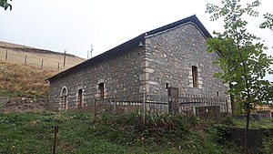 19th-century church of Surb Mesrop in the village | |
| 39°30′18″N 47°01′51″E / 39.50500°N 47.03083°E / 39.50500; 47.03083 | |
| Country |  Azerbaijan Azerbaijan |
| District | Khojavend |
| Population (2015)[1] | |
| • Total | 70 |
| Time zone | UTC+4 (AZT) |
Daghdoshu (Azerbaijani: Dağdöşü, lit. 'mountainside') or Tyak (Armenian: Տյաք) is a village in the Khojavend District of Azerbaijan, in the disputed region of Nagorno-Karabakh. The village is located close to the town of Hadrut. The village had an ethnic Armenian-majority population prior to the 2020 Nagorno-Karabakh war, and also had an Armenian majority in 1989.[2]
History
During the Soviet period, the village was part of the Hadrut District of the Nagorno-Karabakh Autonomous Oblast. After the First Nagorno-Karabakh War, the village was administrated as part of the Hadrut Province of the breakaway Republic of Artsakh. The village came under the control of Azerbaijan during the 2020 Nagorno-Karabakh war.
Historical heritage sites
Historical heritage sites in and around the village include the church of Surb Mesrop (Armenian: Սուրբ Մեսրոպ), a cemetery, and a spring monument from the 19th century.[3]
Demographics
The village had 71 inhabitants in 2005,[4] and 70 inhabitants in 2015.[1]
References
- ^ a b Hakob Ghahramanyan. "Directory of socio-economic characteristics of NKR administrative-territorial units (2015)".
- ^ Андрей Зубов. "Андрей Зубов. Карабах: Мир и Война". drugoivzgliad.com.
- ^ Kiesling, Brady; Kojian, Raffi (2019). Rediscovering Armenia: An in-depth inventory of villages and monuments in Armenia and Artsakh (3rd ed.). Armeniapedia Publishing.
- ^ "The Results of the 2005 Census of the Nagorno-Karabakh Republic" (PDF). National Statistic Service of the Republic of Artsakh.
External links
- Dağdöşü at GEOnet Names Server
- v
- t
- e
Capital: Khojavend (Martuni)
- Ağbulaq
- Ağbulaq
- Ağcakənd
- Ağdam
- Ağkənd
- Arakül
- Arpadüzü
- Arpagədik
- Ataqut
- Avdur
- Axullu
- Azıx
- Binə
- Binədərəsi
- Böyük Tağlar
- Bulutan
- Bünyadlı
- Cəmiyyət
- Cilən
- Cütcü
- Çağadüz
- Çartar
- Çaylaqqala
- Çinarlı
- Çiraquz
- Çörəkli
- Dağdöşü
- Daşbaşı
- Dərəkənd
- Dolanlar
- Düdükçü
- Edilli
- Edişə
- Əmiranlar
- Gavahın
- Günəşli
- Güneyxırman
- Hadrut
- Heşan
- Hünərli
- Kəndxurd
- Kiş
- Köhnə Tağlar
- Kuropatkino
- Məlikcanlı
- Məmməddərə
- Mirikənd
- Muğanlı
- Mülküdərə
- Müşkapat
- Petrosashen
- Qağartsi
- Qaradağlı
- Qarakənd
- Qarazəmi
- Qarıtəpə
- Qarqar
- Qırmızı Bazar
- Qırmızıqaya
- Qoçbəyli
- Quşçular
- Quzeyxırman
- Quzumkənd
- Salakətin
- Sor
- Sos
- Spitakşen
- Susanlıq
- Şahyeri
- Şexer
- Şıx Dursun
- Tağaser
- Tağaverd
- Tuğ
- Xanoba
- Xərxan
- Xırmancıq
- Yemişcan
- Yenikənd
- Zavadıx
- Zərdanaşen
- Zoğalbulaq

| ||
|---|---|---|
Capital: Hadrut | ||
| Urban comunities |  | |
| Rural comunities |
| |
Portal:
 Geography

 | This Khojavend District location article is a stub. You can help Wikipedia by expanding it. |
- v
- t
- e


