Frankenblick
Municipality in Thuringia, Germany

Coat of arms
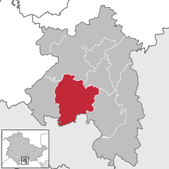
Location of Frankenblick within Sonneberg district
(2022-12-31)[2]
96528
Frankenblick is a municipality in the Sonneberg district of Thuringia, Germany.
Frankenblick was formed on 1 January 2012 by the merger of the former municipalities Effelder-Rauenstein and Mengersgereuth-Hämmern. Today, it consists of the districts Effelder, Rauenstein, Grümpen, Seltendorf, Rabenäußig, Rückerswind, Meschenbach, Döhlau and Mengersgereuth-Hämmern.[3]
Gallery
-
 Effelder church
 -
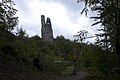 Rauenstein ruin
 -
 Fritz Müller (centre), chairman of the Landwirtschaftliche Produktionsgenossenschaft Seltendorf with MTS-Brigadier Georg Stenzel (left) and agricultural engineer Karl Reichenbacher, August 1958.


References
- ^ Gewählte Bürgermeister - aktuelle Landesübersicht, Freistaat Thüringen, accessed 14 July 2021.
- ^ "Bevölkerung der Gemeinden, erfüllenden Gemeinden und Verwaltungsgemeinschaften in Thüringen Gebietsstand: 31.12.2022" (in German). Thüringer Landesamt für Statistik. June 2023.
- ^ "Frankenblick" (in German). Tourismusverband Franken e.V. Retrieved 18 October 2018.
Wikimedia Commons has media related to Frankenblick.
- v
- t
- e
Towns and municipalities in Sonneberg (district)

Authority control databases | |
|---|---|
| International |
|
| National |
|
| Geographic |
|
 | This Sonneberg district location article is a stub. You can help Wikipedia by expanding it. |
- v
- t
- e


