Hattgenstein
Municipality in Rhineland-Palatinate, Germany

Coat of arms
Location of Hattgenstein within Birkenfeld district

(2019–24) Udo Laube[1]
(2022-12-31)[2]
55767
Hattgenstein is an Ortsgemeinde – a municipality belonging to a Verbandsgemeinde, a kind of collective municipality – in the Birkenfeld district in Rhineland-Palatinate, Germany. It belongs to the Verbandsgemeinde of Birkenfeld, whose seat is in the like-named town.
Geography
Location
The municipality lies at the edge of the Schwarzwälder Hochwald (forest) in the Hunsrück, and 72.2% of the municipal area is wooded. There is a widespread misconception that Hattgenstein, with its average elevation of 534 m above sea level, is the highest place in Rhineland-Palatinate, but this is not true. There are a few places, such as Stein-Neukirch in the High Westerwald and Nürburg in the Eifel, that are higher.[3]
Neighbouring municipalities
To the northeast lies Schwollen, and to the south, Oberhambach.
Constituent communities
Also belonging to Hattgenstein are the outlying homesteads of Helmhof, Waldfriede and Zur Zimmerei.[4]
Politics
Municipal council
The council is made up of 6 council members, who were elected by majority vote at the municipal election held on 7 June 2009, and the honorary mayor as chairman.[5]
Mayor
Hattgenstein's mayor is Udo Laube, re-elected in 2019.[1]
Coat of arms
The municipality's arms might in English heraldic language be described thus: Over a base countercompony gules and argent, gules on a mount vert the Hattgenstein Glockenhaus argent with timber framing sable and doors and windows of the field.
Culture and sightseeing
Buildings

The following are listed buildings or sites in Rhineland-Palatinate’s Directory of Cultural Monuments:[6]
- Am Brunnen 2 – Quereinhaus (a combination residential and commercial house divided for these two purposes down the middle, perpendicularly to the street), partly timber-frame, partly slated, late 18th or early 19th century
- Am Brunnen 4 – former winepress house, timber-frame building
- Flurstraße 3 – Quereinhaus, partly timber-frame, possibly from the earlier half of the 19th century
- Hauptstraße 13 – so-called Glockenhaus (“Bell House”); partly timber-frame, half-hipped roof, bell turret, 1762; characterizes village's appearance
- Hauptstraße 17 – stately Quereinhaus, partly timber-frame, possibly from the early 19th century
The Glockenhaus (“Bell House”) is Hattgenstein's main landmark. It was built in 1762 as a school building and a dwelling for the beadle.
Natural monuments
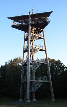
Hattgensteiner Fels, a crag with a lookout tower near the sporting ground, is believed to be the village's namesake.
Economy and infrastructure
Transport
To the west runs Bundesstraße 269, and to the south, the Autobahn A 62 (Kaiserslautern–Trier). Available in nearby Neubrücke is a railway station on the Nahe Valley Railway (Bingen–Saarbrücken).
References
- ^ a b Direktwahlen 2019, Landkreis Birkenfeld, Landeswahlleiter Rheinland-Pfalz, accessed 10 August 2021.
- ^ "Bevölkerungsstand 2022, Kreise, Gemeinden, Verbandsgemeinden" (PDF) (in German). Statistisches Landesamt Rheinland-Pfalz. 2023.
- ^ Elevation misconception
- ^ Statistisches Landesamt Rheinland-Pfalz – Amtliches Verzeichnis der Gemeinden und Gemeindeteile Archived 2015-11-25 at the Wayback Machine, Seite 19 (PDF)
- ^ Kommunalwahl Rheinland-Pfalz 2009, Gemeinderat
- ^ Directory of Cultural Monuments in Birkenfeld district
External links
Wikimedia Commons has media related to Hattgenstein.
- Municipality’s official webpage (in German)
- v
- t
- e
Towns and municipalities in Birkenfeld (district)
- Abentheuer
- Achtelsbach
- Allenbach
- Asbach
- Baumholder
- Bergen
- Berglangenbach
- Berschweiler bei Baumholder
- Berschweiler bei Kirn
- Birkenfeld
- Bollenbach
- Börfink
- Breitenthal
- Bruchweiler
- Brücken
- Buhlenberg
- Bundenbach
- Dambach
- Dickesbach
- Dienstweiler
- Eckersweiler
- Elchweiler
- Ellenberg
- Ellweiler
- Fischbach
- Fohren-Linden
- Frauenberg
- Gerach
- Gimbweiler
- Gollenberg
- Gösenroth
- Griebelschied
- Hahnweiler
- Hattgenstein
- Hausen
- Heimbach
- Hellertshausen
- Herborn
- Herrstein
- Hettenrodt
- Hintertiefenbach
- Hoppstädten-Weiersbach
- Horbruch
- Hottenbach
- Idar-Oberstein
- Kempfeld
- Kirschweiler
- Kronweiler
- Krummenau
- Langweiler
- Leisel
- Leitzweiler
- Mackenrodt
- Meckenbach
- Mettweiler
- Mittelreidenbach
- Mörschied
- Niederbrombach
- Niederhambach
- Niederhosenbach
- Niederwörresbach
- Nohen
- Oberbrombach
- Oberhambach
- Oberhosenbach
- Oberkirn
- Oberreidenbach
- Oberwörresbach
- Reichenbach
- Rhaunen
- Rimsberg
- Rinzenberg
- Rohrbach
- Rötsweiler-Nockenthal
- Rückweiler
- Ruschberg
- Schauren
- Schmidthachenbach
- Schmißberg
- Schwerbach
- Schwollen
- Sensweiler
- Sien
- Sienhachenbach
- Siesbach
- Sonnenberg-Winnenberg
- Sonnschied
- Stipshausen
- Sulzbach
- Veitsrodt
- Vollmersbach
- Weiden
- Weitersbach
- Wickenrodt
- Wilzenberg-Hußweiler
- Wirschweiler

Authority control databases | |
|---|---|
| International |
|
| National |
|


