Honcut Creek
Stream in California, United States
| Honcut Creek | |
|---|---|
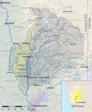 Map of the Feather River watershed including Honcut Creek | |
| Location | |
| Country | United States |
| State | California |
| Physical characteristics | |
| Source | |
| • location | Sierra Nevada, near Lake Oroville |
| Mouth | |
• location | Feather River |
• elevation | 72 feet (22 m) |
| Length | 20 miles (32 km) to farthest source |
| Basin size | 130 square miles (340 km2) |
| Basin features | |
| River system | Sacramento River |
| Tributaries | |
| • left | Wilson Creek |
Honcut Creek is a stream in central California in the United States. It is a tributary of the Feather River and flows from the Sierra Nevada south and west into the river] in the Sacramento Valley.
The headwaters are in the Sierra Nevada, and include: North Honcut, Upper Rocky Honcut, South Honcut, and Natchez creeks. The creek area in the lower Feather River watershed includes Honcut, California, and locations of former settlements such as the Maidu's Honkut at the mouth of Honcut Creek and Honcut City, California, along North Honcut Creek.[1]
See also
- Feather Headwaters
References
- ^ Blodgett, J. C. (1982). Floodflow Characteristics of Honcut Creek at State Highway 70 Bridges Near Live Oak, California. U.S. Geological Survey.
39°17′44″N 121°37′28″W / 39.2955°N 121.6244°W / 39.2955; -121.6244
- v
- t
- e
Rivers of California's Central Valley watershed (north-to-south)
- Pit River
- McCloud River
- Cow Creek
- Cottonwood Creek
- Battle Creek
- Mill Creek
- Deer Creek
- Thomes Creek
- Big Chico Creek
- Stony Creek
- Butte Creek
- Feather River
- North Fork
- East Branch
- West Branch
- Middle Fork
- South Fork
- Yuba River
- Bear River
- American River
- Cache Creek
- Putah Creek
- Kings River
- Kaweah River
- Tule River
- White River
- Poso Creek
- Kern River
 | This Butte County, California-related article is a stub. You can help Wikipedia by expanding it. |
- v
- t
- e
This article related to a river in California is a stub. You can help Wikipedia by expanding it. |
- v
- t
- e


