Hongshulin station
Metro station in New Taipei, Taiwan
Hongshulin R27/V01 紅樹林  | |||||||||||||||||||||
|---|---|---|---|---|---|---|---|---|---|---|---|---|---|---|---|---|---|---|---|---|---|
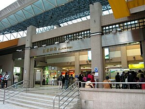 Hongshulin station Entrance | |||||||||||||||||||||
| Chinese name | |||||||||||||||||||||
| Traditional Chinese | 紅樹林 | ||||||||||||||||||||
| Simplified Chinese | 红树林 | ||||||||||||||||||||
| Literal meaning | Mangrove forest | ||||||||||||||||||||
| |||||||||||||||||||||
| General information | |||||||||||||||||||||
| Location | No. 68, Zhongzheng East Road, Sec. 2 Tamsui, New Taipei Taiwan | ||||||||||||||||||||
| Operated by |
| ||||||||||||||||||||
| Line(s) |
| ||||||||||||||||||||
| Connections | Bus stop | ||||||||||||||||||||
| Construction | |||||||||||||||||||||
| Structure type | At-Grade (Tamsui-Xinyi line) / Elevated (Danhai light rail) | ||||||||||||||||||||
| History | |||||||||||||||||||||
| Opened | 25 December 1997 | ||||||||||||||||||||
| Passengers | |||||||||||||||||||||
| daily (December 2020)[1] | |||||||||||||||||||||
| Rank | 93 out of 109 | ||||||||||||||||||||
| Services | |||||||||||||||||||||
| |||||||||||||||||||||
Hongshulin (formerly transliterated as Hung Shulin Station until 2003) is a metro and light rail station in New Taipei, Taiwan, operated by Taipei and New Taipei Metro respectively. The location of station could be traced back the station of the same name on the now-defunct Tamsui railway line.
The station is a terminus for the Danhai light rail serving Danhai New Town.[2]
Station overview

The at-grade, station structure with two side platforms and two exits.[3] The washrooms are inside the entrance area.
The station is situated on the east of Zhongzheng West Road, around Bashe Road entrance. The name of the station derives from the protected habitat "Hongshulin" (literally "red forest", means Mangrove), the Hongshulin environmental protection zone is located west of the station.
Station layout
| 2F | Connecting Level | Connecting Skyway to Tamsui–Xinyi Line |
| Platform 1 |  Danhai light rail to Kanding (V02 Ganzhenlin) → Danhai light rail to Kanding (V02 Ganzhenlin) → | |
| Island platform, doors open on the left, right | ||
| Platform 2 | Danhai light rail to Tamsui Fisherman's Wharf (V02 Ganzhenlin) → | |
| Street Level | |
| Concourse (to Platform 1) | |
| Entrance/Exit, lobby, information desk, convenience store, automatic ticket dispensing machines, one-way faregates Restrooms | |
| Side platform, doors will open on the right | |
| Platform 1 | ←  Tamsui–Xinyi line toward Tamsui (R28 Terminus) Tamsui–Xinyi line toward Tamsui (R28 Terminus) |
| Platform 2 | → Tamsui–Xinyi line toward Xiangshan (R26 Zhuwei) → |
| Side platform, doors will open on the right | |
References
Wikimedia Commons has media related to Hongshulin Station.
- ^ "Passenger Volume at Taipei Rapid Transit Stations". Taipei Mass Rapid Transit Co., Ltd. 2021-01-15.
- ^ "CEPD mulling MRT line to Danhai New Township". Taipei Times. 2010-05-02. Retrieved 2010-05-05.
- ^ "Route Map: Hongshulin". Taipei Rapid Transit Corporation. Retrieved 2010-06-20.[permanent dead link]
- v
- t
- e
Taipei Metro stations
(Boldface denotes an MRT interchange station; italic denotes stations under construction.)
 Wenhu
Wenhu- Taipei Nangang Exhibition Center ■
- Nangang Software Park
- Donghu
- Huzhou
- Dahu Park
- Neihu
- Wende
- Gangqian
- Xihu
- Jiannan Road ■
- Dazhi
- Songshan Airport
- Zhongshan Junior High School
- Nanjing Fuxing ■
- Zhongxiao Fuxing ■
- Daan ■
- Technology Building
- Liuzhangli
- Linguang
- Xinhai
- Wanfang Hospital
- Wanfang Community
- Muzha
- Taipei Zoo ■
Tamsui–Xinyi- Tamsui
- Hongshulin ■
- Zhuwei
- Guandu
- Zhongyi
- Fuxinggang
- Beitou
- Qiyan
- Qilian
- Shipai
- Mingde
- Zhishan
- Shilin ■
- Jiantan
- Yuanshan
- Minquan W. Road ■
- Shuanglian
- Zhongshan ■
- Taipei Main Station ■
- NTU Hospital
- Chiang Kai-shek Memorial Hall ■■
- Dongmen ■
- Daan Park
- Daan ■
- Xinyi Anhe
- Taipei 101/World Trade Center
- Xiangshan (■)
- Guangci–Fengtian Temple
| Xinbeitou Branch |
|---|
 Songshan–Xindian
| Xiaobitan Branch |
|---|
 Zhonghe–Xinlu
| Services to Luzhou | |
|---|---|
| Services to Huilong |
 Bannan
- Dingpu
- Yongning (■)
- Tucheng ■
- Haishan
- Far Eastern Hospital
- Fuzhong
- Banqiao (■)
- Xinpu (■)
- Jiangzicui
- Longshan Temple
- Ximen ■
- Taipei Main Station ■
- Shandao Temple
- Zhongxiao Xinsheng ■
- Zhongxiao Fuxing ■
- Zhongxiao Dunhua
- Sun Yat-sen Memorial Hall
- Taipei City Hall
- Yongchun (■)
- Houshanpi
- Kunyang
- Nangang
- Taipei Nangang Exhibition Center ■
 Wanda–Zhonghe–Shulin
- Chiang Kai-shek Memorial Hall ■■
- Taipei Botanical Garden
- Xiaan
- Kalah
- Yonghe Yongping Elementary School
- Zhonghe ■
- Liancheng Jinhe
- Zhonghe Senior High School
- Tingliao
- Qingshui
- Tucheng ■
- Pitang (■)
- Chenglin Bridge
- Xizhou
- Pengfu
- Beinei
- Shulin
- Tandi
- Taipei Motor Vehicles Office
- Sanjiaopu
- Huilong ■
| Juguang Branch |
|---|
New Taipei Metro stations | |||||
|---|---|---|---|---|---|
(Boldface denotes an MRT interchange station; italic denotes stations under construction.) | |||||
| Danhai |
| ||||
 Ankeng Ankeng | |||||
 Circular Circular |
| ||||
 Sanying Sanying | |||||
| |||||||
|---|---|---|---|---|---|---|---|
| Stations |
| ||||||
| Rolling stock |
| ||||||

| |
|---|---|
| In operation |
|
| Under construction or planned |
|
25°09′15″N 121°27′32″E / 25.154103°N 121.459002°E / 25.154103; 121.459002
 | This Taiwanese rapid transit article is a stub. You can help Wikipedia by expanding it. |
- v
- t
- e


