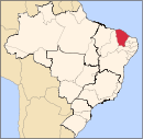
Municipality in Northeast, Brazil
Flag

Seal
| Nickname: "Porronca" |
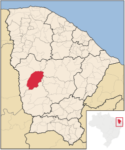 Location of Independência in the State of Ceará |
| Coordinates: 05°23′45″S 40°18′32″W / 5.39583°S 40.30889°W / -5.39583; -40.30889 |
| Country |  Brazil Brazil |
|---|
| Region | Northeast |
|---|
| State |  Ceará Ceará |
|---|
| Founded | July 24, 1857 |
|---|
| Government |
|---|
| • Mayor | José Valdi Coutinho (PMDB) |
|---|
| Area |
|---|
| • Total | 3,218.641 km2 (1,242.724 sq mi) |
|---|
| Elevation | 105 m (343 ft) |
|---|
| Population (2020 [1]) |
|---|
| • Total | 26,187 |
|---|
| • Density | 8.1/km2 (21/sq mi) |
|---|
| Time zone | UTC-3 (UTC-3) |
|---|
| HDI (2000) | 0.657 – medium[2] |
|---|
| Website | www.independencia.ce.gov.br/ |
|---|
Independência is a municipality of the Northeastern state of Ceará in Brazil. It is the fourth largest by area in that state.
References
- ^ IBGE 2020
- ^ [1] Archived 2009-10-03 at the Wayback Machine UNDP
Capital: Fortaleza |
Centro-Sul Cearense |
|---|
| Iguatu | |
|---|
| Lavras da Mangabeira | |
|---|
| Varzea Alegre | |
|---|
|
| |
Jaguaribe |
|---|
| Baixo Jaguaribe | |
|---|
| Litoral de Aracati | |
|---|
| Medio Jaguaribe | |
|---|
| Serra do Pereiro | |
|---|
|
|
Metropolitana de Fortaleza |
|---|
|
|
Noroeste Cearense |
|---|
| Coreau | |
|---|
| Ibiapaba | |
|---|
| Ipu | |
|---|
| Litoral de Camocim e Acarau | |
|---|
| Meruoca | |
|---|
| Santa Quiteria | |
|---|
| Sobral | |
|---|
|
|
Norte Cearense |
|---|
| Baixo Curu | |
|---|
| Baturite | |
|---|
| Caninde | |
|---|
| Cascavel | |
|---|
| Chorozinho | |
|---|
| Itapipoca | |
|---|
| Medio Curu | |
|---|
| Uruburetama | |
|---|
|
|
Sertoes Cearenses |
|---|
| Sertao de Crateus | |
|---|
| Sertao de Inhamuns | |
|---|
| Sertao de Quixeramobim | |
|---|
| Sertao de Senador Pompeu | |
|---|
|
|
Sul Cearense |
|---|
| Barro | |
|---|
| Brejo Santo | |
|---|
| Cariri | |
|---|
| Caririacu | |
|---|
| Chapada do Araripe | |
|---|
|
|
Authority control databases  | |
|---|
 | This Ceará, Brazil location article is a stub. You can help Wikipedia by expanding it. |


 Brazil
 Ceará
Ceará