Jalpaiguri division
Division in West Bengal, India
Jalpaiguri | |
|---|---|
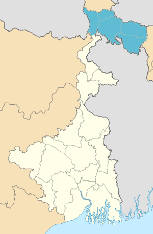 Location of Jalpaiguri in West Bengal | |
 Interactive Map Outlining Jalpaiguri | |
| Country |  India India |
| State |  West Bengal West Bengal |
| Established | 1947 |
| Capital | Jalpaiguri |
| Districts | Alipurduar, Cooch Behar, Darjeeling, Jalpaiguri, Kalimpong |
| Area | |
| • Total | 18,200 km2 (7,000 sq mi) |
| Population (2011) | |
| • Total | 8,538,755 |
| • Density | 470/km2 (1,200/sq mi) |
Jalpaiguri Division is one of the 5 divisions in the Indian state of West Bengal. It is the northernmost division of West Bengal. It is surrounded by Nepal on the western side, Bihar on South-Western side, Bhutan on the Northern side and Bangladesh on the southern side.[1]
Districts

It consists of 5 districts:[2]
| Code | District | Headquarters | Established | Sub-Division | Area | Population As of 2011 | Population Density | Map |
|---|---|---|---|---|---|---|---|---|
| DA | Darjeeling | Darjeeling | 1947 | 2,092.5 km2 (807.9 sq mi) | 1,797,422 | 859/km2 (2,220/sq mi) |  | |
| JP | Jalpaiguri | Jalpaiguri | 1947 | 2,844 km2 (1,098 sq mi) | 2,172,846 | 621/km2 (1,610/sq mi) |  | |
| KB | Cooch Behar | Cooch Behar | 1950[3] | 3,387 km2 (1,308 sq mi) | 2,822,780 | 833/km2 (2,160/sq mi) |  | |
| AD | Alipurduar | Alipurduar | 2014[4] | 3,383 km2 (1,306 sq mi) | 1,700,000 | 400/km2 (1,000/sq mi) |  | |
| KA | Kalimpong | Kalimpong | 2017[4] | 1,044 km2 (403 sq mi) | 251,642 | 239/km2 (620/sq mi) | 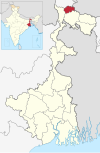 | |
| Total | 5 | — | - | 13 | 12,713 km2 (4,909 sq mi) | 8,790,397 | 691/km2 (1,790/sq mi) |  |
Demographics
| Religion in Jalpaiguri division | ||||
|---|---|---|---|---|
| Hinduism | 77.43% | |||
| Islam | 14.88% | |||
| Christianity | 3.89% | |||
| Buddhism | 3.05% | |||
| Others | 0.75% | |||
Hindus forms the majority of the population while Muslims forms the largest minority group. There is a significant Christian and Buddhist population in the division. They are mainly concentrated in Kalimpong district and hill subdivisions of Darjeeling district. The Dooars regions also has a significant tribal population.[5]
References
- ^ "Divisional Commissioners/ West Bengal". Office of the Resident Commissioner- Govt. of WB. 4 June 2019.
- ^ "Directory of District, Sub division, Panchayat Samiti/ Block and Gram Panchayats in West Bengal, March 2008". West Bengal. National Informatics Centre, India. 19 March 2008. p. 1. Archived from the original on 25 February 2009. Retrieved 28 February 2009.
- ^ "Brief History of Cooch Behar". Official website of Cooch Behar District. Archived from the original on 24 July 2011. Retrieved 10 September 2008.
- ^ a b Jana, Naresh (31 December 2001). "Tamluk readies for giant's partition". The Telegraph (Kolkata). Archived from the original on 14 March 2014. Retrieved 1 September 2008.
- ^ Population by religious community: West Bengal. 2011 Census of India.
- v
- t
- e
State of West Bengal
- Gauda Kingdom
- Pala Empire
- Sena dynasty
- Mallabhum kingdom
- Cooch Behar State
- Sher Shah Suri
- Mughal Empire
- Nawabs of Bengal
- East India Company
- Battle of Plassey
- Bengal Presidency
- Great Bengal famine of 1770
- Indian Rebellion of 1857
- Bengal Renaissance
- Bardhaman Raj
- Nadia Raj
- Jhargram Raj
- Sovabazar Raj
- Partition of Bengal (1905)
- Revolutionary movement for Indian independence
- Anushilan Samiti
- Jugantar
- Bengal famine of 1943
- Direct Action Day
- Noakhali riots
- Partition of Bengal (1947)
- Bengali Language Movement (Manbhum)
- Bangladesh Liberation War
- Naxalite–Maoist insurgency
- Chief Ministers
- Governor
- Legislative Assembly
- Human Rights Commission
- Political parties (All India Trinamool Congress
- Communist Party (Marxist)
- Indian National Congress
- Bharatiya Janata Party)
- Parliamentary constituencies
- Assembly constituencies
- CID West Bengal
- Kolkata Police
districts
| Burdwan division | |
|---|---|
| Jalpaiguri division | |
| Malda division |
|
| Medinipur division |
|
| Presidency division |
|
towns
- Alipore
- Asansol
- Berhampore
- Balurghat
- Bankura
- Barasat
- Bardhaman
- Bishnupur
- Hugli-Chuchura
- Cooch Behar
- Darjeeling
- Durgapur
- Haldia
- Howrah
- Jalpaiguri
- Jaynagar Majilpur
- Jiaganj Azimganj
- Kalimpong
- Kharagpur
- Kolkata
- Krishnanagar
- Kurseong
- Malda
- Midnapore
- Murshidabad
- Purulia
- Raiganj
- Siliguri
- Siuri
- Tamluk
- List of cities in West Bengal by population
- Cities and towns by district
- Bengal Renaissance
- Bengali calendars
- Patachitra
- Chalchitra
- Arts of West Bengal
- Baul
- Bhadu
- Gombhira
- Chhau dance
- Cuisine
- Rabindra Sangeet
- Rabindra Nritya Natya
- Holi
- Prostitution in Kolkata
- Pohela Boishakh
- Durga Puja
- Bhai Dooj
- Raksha Bandhan
- Ratha Yatra
- Architecture of Bengal
- Bengali language
- Bengali literature
- Feluda
- Lalmohan Ganguly
- Professor Shonku
- Tarini Khuro
- Kakababu
- Kiriti Roy
- Pather Panchali (novel)
- Bengali cinema
- Jatra
- Ghosts in Bengali culture
- Baluchari sari
- Banglar Rosogolla
- Banglar Muslin
- Bankura horse
- Bengal Patachitra
- Chhau mask
- Darjeeling tea
- Dhaniakhali Sari
- Dhokra
- Fazli (mango)
- Garad Saree
- Gobindobhog
- Himsagar
- Jaynagarer Moa
- Madurkathi
- Manasa chali
- Mihidana
- Nakshi kantha
- Santiniketan Leather Goods
- Shantipuri sari
- Sitabhog
- Sundarban Honey
- Tangail Saree
- Tulaipanji
- Rabindranath Tagore
- Satyajit Ray
- Kazi Nazrul Islam
- Anil Kumar Gain
- Ritwik Ghatak
- Subhas Chandra Bose
- Jamini Roy
- Bidhan Chandra Roy
- Jyoti Basu
- Nandalal Bose
- Jagadish Chandra Bose
- Meghnad Saha
- Bankim Chandra Chatterjee
- Sarat Chandra Bose
- Jnanadanandini Devi
- Abanindranath Tagore
- Satyendranath Tagore
- Satyendranath Dutta
- Raja Ram Mohan Roy
- Ishwar Chandra Vidyasagar
- Rani Rashmoni
- Ramakrishna
- Swami Vivekananda
- Sarada Devi
- Dwarkanath Tagore
- Sukumar Ray
- Upendrakishore Ray Chowdhury
- Michael Madhusudan Dutt
- Sarat Chandra Chattopadhyay
- Sister Nivedita
- Mother Teresa
- Amartya Sen
- Bibhutibhushan Bandyopadhyay
- Nihar Ranjan Gupta
Image gallery at Wikimedia Commons
26°31′N 88°44′E / 26.52°N 88.73°E / 26.52; 88.73


