Kerk-Avezaath
Village in Gelderland, Netherlands
51°54′N 5°23′E / 51.900°N 5.383°E / 51.900; 5.383[1]
[2]
(2021)[1]
4012[1]
Kerk-Avezaath is a village in the Dutch province of Gelderland. It is a part of the municipality of Buren, and lies about 3 km west of Tiel.
A small part of the village (not counted in the statistics above) is part of the municipality of Tiel, and consists of about 60 houses.[3]
History
It was first mentioned in 850 as Auansati, and means "church at the house of Avo (person)".[4] The village developed along two parallel roads on a stream, and a stretched esdorp developed. The tower of the Dutch Reformed Church dates from 1640 and has an 11th century base. The church dates from 1861 and has 14th century elements.[5] In 1840, it was home to 449 people.[3]
Gallery
-
 St. Lambertus Church
 -
 Huis Kellendonk
 -
 Huis ten Ham
 -
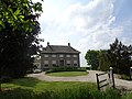 Farm in Kerk-Avezaath


References
- ^ a b c "Kerncijfers wijken en buurten 2021". Central Bureau of Statistics. Retrieved 21 March 2022.
two entries
- ^ "Postcodetool for 4012BA". Actueel Hoogtebestand Nederland (in Dutch). Het Waterschapshuis. Retrieved 21 March 2022.
- ^ a b "Kerk-Avezaath". Plaatsengids (in Dutch). Retrieved 21 March 2022.
- ^ "Kerk-Avezaath - (geografische naam)". Etymologiebank (in Dutch). Retrieved 21 March 2022.
- ^ Ronald Stenvert & Sabine Broekhoven (2000). "Kerk-Avezaath" (in Dutch). Zwolle: Waanders. p. 211. ISBN 90 400 9406 3. Retrieved 20 March 2022.
- v
- t
- e
Populated places in the municipality of Buren
- Maurik
- Buren
- Asch
- Beusichem
- Buurmalsen
- Eck en Wiel
- Erichem
- Ingen
- Kapel-Avezaath
- Kerk-Avezaath
- Lienden
- Ommeren
- Ravenswaaij
- Rijswijk
- Zoelen
- Zoelmond
- Aalst
- Bontemorgen
- De Bosjes
- Essebroek
- Ganzert
- De Heuvel
- Hoog Kana
- Hoogmeien
- Klinkenberg
- Luchtenburg
- Lutterveld
- De Mars
- Meerten
- Meertenwei
- Ommerenveld
- Tweesluizen
- Zandberg
- Zevenmorgen
- Zwarte Paard
 | This Gelderland location article is a stub. You can help Wikipedia by expanding it. |
- v
- t
- e


 Kerk-Avezaath