Lava Butte
Cinder cone in central Oregon, United States


Lava Butte
Deschutes County, Oregon, U.S.
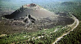
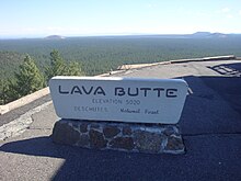
Lava Butte is a cinder cone in central Oregon, United States, just west of U.S. Route 97 between the towns of Bend, and Sunriver in Deschutes County. It is part of a system of small cinder cones on the northwest flank of Newberry Volcano, a massive shield volcano which rises to the southeast. The cinder cone is capped by a crater which extends about 60 feet (20 m) deep beneath its south rim, and 160 feet (50 m) deep from the 5,020-foot (1,530 m) summit on its north side. Lava Butte is part of the Newberry National Volcanic Monument.
Volcanic history

Like the other cinder cones in the area, Lava Butte only experienced a single eruption, dated by geologists in 1977 to 6,150 carbon-14 years, equivalent to about 7,000 years ago. The eruption began with a fissure spewing hot cinders to form the cone. In the next phase, a river of hot basalt flowed from the base of the small volcano to cover a large area to the west with a lava flow which remains largely free of vegetation. The lava flows reached the Deschutes River about 2.5 miles (4.0 km) to the west of the cone, burying its former channel under over 100 feet (30 m) of lava and damming the river to form a lake, known as Lake Benham. The river eventually overflowed the lava dam and eroded down into it, draining the lake and forming Benham Falls. Geologists estimate that 90% of the magma erupted as lava flows, 9% as scoria which forms the cone, and 1% as volcanic ash which forms a thin layer extending to the north.
Human history
The early history of Lava Butte is not known, but it is assumed that Native Americans observed the eruptions and later ascended the prominent new landmark. White settlers arriving in the 1800s also noted the landmark. In 1903, I.C. Russell was the first geologist to study the butte and speculated that it erupted as recently as 150 years ago.[3] Dr. Howel Williams estimated it to be much older, but incorrectly at 1,000 years old.[3] In September 1914, Lava Butte "erupted" when the Bend Chamber of Commerce simulated an eruption to surprise a visiting Portland group. In 1925, USGS geologist Harold Stearns studied the Newberry area and recognized the fissure system which extends from Lava Butte to East Lake within Newberry Caldera.
Sometime after 1901, the Great Northern Railway was extended south through the area. The construction crew built the rail line directly through the ʻAʻā lava flow of Lava Butte.[3]
The cinder cone was also exploited to some extent for its economic value. In June 1926, a quarry was developed in the fault scarp east of Lava Butte as a source for paving material for the first The Dalles-California Highway (later U.S. Route 97). In November 1929, cinders from Lava Butte were shipped to Longview, Washington, to be used in construction of Longview Bridge across Columbia River.
A United States Forest Service fire lookout tower was built on the summit in 1931, and in early 1933 a steep, single-lane road was constructed spiraling up to the summit. In February of that year, the local Skyliners ski club proposed a ski jump on Lava Butte, but it was never built. In June 1946, widening of the road up Lava Butte to two lanes was completed, along with constructing two small parking lots at the summit. The road was later paved in July 1950. The original lookout was replaced with a larger one in 1957, which was subsequently enlarged in 1962 to accommodate a small visitor center and museum on the first floor. In 1998 this was replaced with a new lookout built in the original L-4 style of 1931.
In July 1966, twenty-two astronauts trained in Central Oregon for the upcoming Moon landings, at sites including Lava Butte, Lava River Cave, and Newberry Crater. In May 1967 the U.S. Forest Service created the 8,983 acres (3,635 ha) Lava Butte Geological Area to protect the cinder cone, with plans for recreational and interpretive development. Construction of the Lava Lands Visitor Center located just south of the cone began in April 1969 and it was finally dedicated in September 1975. In November 1990, Newberry National Volcanic Monument was created encompassing Newberry Crater, Lava Cast Forest Geological Area, Lava River Cave, and the Lava Butte Geological Area.
From early May to mid October, a shuttle transports visitors up Red Cinder Road from the Lava Lands Visitor Center to the lookout on Lava Butte. Hiking up Red Cinder Road is a year-round option. A scenic rim trail around the top of Lava Butte is 0.35 miles (0.56 km) long.[4]
See also
- Tumalo Volcanic Center, of which Lava Butte is part
References
- ^ a b "Lava Butte Reset". NGS Data Sheet. National Geodetic Survey, National Oceanic and Atmospheric Administration, United States Department of Commerce. Retrieved 2012-05-04.
- ^ "Lava Butte, Oregon". Peakbagger.com. Retrieved 2012-05-04.
- ^ a b c Brogan, Phil F. (1962). The Lava Butte Geological Area. Deschutes National Forest United States Forest Service. p. 12.
- ^ "Lava Butte in Newberry National Volcanic Monument". hikespeak.com. Hikespeak. Retrieved December 20, 2018.
- "Lava Butte Vicinity, Oregon". USGS Cascades Volcano Observatory. Retrieved 2008-04-01.
- Harris, Stephen L. (2005). Fire Mountains of the West: The Cascade and Mono Lake Volcanoes (3rd ed.). Mountain Press Publishing Company. pp. 177–8. ISBN 0-87842-511-X.
- Wood, Charles A.; Kienle, Jürgen, eds. (1990). Volcanoes of North America. Cambridge University Press. p. 202. ISBN 0-521-43811-X.
- "Deschutes & Ochoco National Forests: History". US Forest Service. Archived from the original on 2011-03-16. Retrieved 2008-04-01.
- Kresek, Ray (1998). Fire Lookouts of the Northwest (3rd ed.). Historic Lookout Project. ISBN 0-87770-632-8.
- "Lava Butte Lookout". National Historic Lookout Register. Archived from the original on 2011-07-23. Retrieved 2008-04-01.
External links
Wikimedia Commons has media related to Lava Butte.
- "Newberry National Volcanic Monument". US Forest Service. Archived from the original on 2010-06-10. Retrieved 2008-04-01.
- "Architectural drawing of 1957 Lava Butte Lookout Tower" (PDF). US Forest Service. Retrieved 2008-04-01.
- "Map of Lava Butte, Deschutes County, Oregon" (PDF). oregongeology.org. Retrieved 2018-05-31.
- v
- t
- e
- Applegate Peak
- Aspen Butte
- Bald Crater
- Ball Butte
- Barlow Butte
- Bear Butte
- Belknap Crater
- Black Butte
- Black Crater
- Broken Top
- Buckskin Butte
- Cache Mountain
- Chinquapin Mountain
- Clear Lake Butte
- Cleetwood
- Crater Lake
- Crater Mountain
- Crater Peak
- Cryder Butte
- Cupit Mary Mountain
- Danger Bay
- Davis Lake Volcanic Field
- Davis Mountain
- Desert Cone
- Diamond Peak
- Dry Butte
- Dutton Cliff
- Egan Cone
- Forgotten Cone
- Fort Butte
- Frog Lake Buttes
- Fuji Mountain
- Garfield Peak
- Greylock Mountain
- Grouse Hill
- Hamner Butte
- Hayrick Butte
- Hillman Peak
- Hogg Rock
- Hoodoo Butte
- Howlock Mountain
- Irish Mountain
- Katsuk Butte
- Kwolh Butte
- Lemiti Butte
- Le Conte Crater
- Llao Bay
- Llao Rock
- Little Aspen Butte
- Little Belknap
- Little Brother
- Little Cache Mountain
- Little Chinquapin Mountain
- Little Nash Crater
- Lolah Butte
- Lost Lake Cinder Cones
- Lookout Butte
- Lookout Mountain
- Lumrum Butte
- Maiden Peak
- Maklaks Crater
- Maklaks Mountain
- Melvin Butte
- Merriam Cone
- Merriam Point
- Mount Bachelor
- Mount Bailey
- Mount Carmine
- Mount Harriman
- Mount Hood
- Mount Jefferson
- Mount Mazama
- Mount McLoughlin
- Mount Multnomah (unconfirmed)
- Mount Ray
- Mount Scott (Klamath)
- Mount Thielsen
- Mount Washington
- Mount Wilson
- Nash Crater
- North Pinhead Butte
- North Wilson
- Odell Butte
- Oregon's Matterhorns
- Olallie Butte
- Peavine Mountain
- Pelican Butte
- Phantom Ship
- Pinhead Buttes
- Pine Marten Mountain
- Pothole Butte
- Redcloud
- Red Box
- Red Cone
- Red Crater
- Ringo Butte
- Robinson Butte
- Rock Butte
- Rock Mesa
- Royce Mountain
- Rustler Peak
- Sand Mountain
- Sand Mountain Volcanic Field
- Scout Hill
- Sentinel Rock
- Sharp Peak
- Sheridan Mountain
- Siah Butte
- Sisi Butte
- South Belknap
- South Pinhead Butte
- Summit Butte
- Talapus Butte
- Teardrop Pool
- The Husband
- The Pinnacle
- The Twins
- The Wife
- Three Fingered Jack
- Three Sisters (North Sister, Middle Sister, South Sister)
- Three Trappers
- Timber Crater
- Tom Dick and Harry Mountain
- Tot Mountain
- Triangle Hill
- Triangle Peak
- Tumalo Mountain
- Tumalo Volcanic Center
- Twin Craters
- Union Peak
- Waldo Mountain
- West Pinhead Butte
- Whiteface Peak
- Williamson Mountain
- Wizard Island
- Zigzag Mountain
- Angels Rest
- Armet Creek
- Baldy
- Battle Ax
- Bone Mountain
- Boring Lava Field
- Cascade Head
- Chamberlain Hill
- Clatsop Butte
- Cook's Butte
- Crescent Mountain
- Devil's Rest
- East Buttes
- French's Dome
- Elk Point
- Elk Rock Island
- Grass Mountain
- Grizzly Peak
- Harter Mountain
- Highland Butte
- High Prairie
- Hunsinger Peak
- Indian Mountain
- Iron Mountain
- Kelly Butte
- Larch Mountain
- Laurel Mountain
- Lenhart Butte
- Little Butte Volcanics
- Little Pilot Rock
- Lookout Point
- Lost Lake Butte
- Marys Peak
- Mount Ashland
- Mount Defiance
- Mount Hebo
- Mount Pisgah
- Mount Scott (Clackamas)
- Mount Sylvania
- Mount Tabor
- Mount Talbert
- Nesmith Point
- Olson Mountain
- Oregon's Matterhorns
- Palmer Peak
- Pepper Mountain
- Pilot Rock
- Powell Butte
- Rocky Butte
- Rogers Peak
- Ross Mountain
- Roxy Ann Peak
- Saddle Mountain
- Scout Camp
- Siletz River Volcanics
- Snow Peak
- Southern Oregon Coast Range
- Spencer Butte
- Sunshine Rock
- Swede Hill
- Three Pyramids
- Tualatin Mountains
- TV Hill
- Upper and Lower Table Rock
- Walker Peak
- Willamette National Cemetery
- Bald Mountain
- Bald Mountain Caldera
- Barnes Butte
- Bly Mountain
- China Hat
- Cline Buttes
- Crooked River Caldera
- Deschutes Formation
- Hager Mountain
- Horse Ridge
- Gearhart Mountain
- Gray Butte
- Grizzly Mountain
- Lava Butte (Newberry/Tumalo)
- Monkeyface
- Newberry Volcano
- Ochoco Mountains
- Oregon Badlands Wilderness
- Paulina Peak
- Pilot Butte
- Pine Mountain
- Powell Buttes
- Round Butte
- Smith Rock
- Smith Rock State Park
- Tea Table Mountain
- Wildcat Mountain
- Wildcat Mountain Caldera
- Yainax Butte
- Yainax Ridge
- Yamsay Mountain
- Big Hole
- Black Hills
- Chalk Basin
- Clarks Butte
- Clarno Unit
- Devils Garden Volcanic Field
- Dooley Mountain
- Diamond Craters
- Doherty Slide
- Drake Peak
- Fort Rock
- Fort Rock-Christmas Lake Valley Basin
- Four Craters Lava Field
- Glass Buttes
- Hager Mountain
- Harney Basin
- Harney Basin Volcanic Field
- Hole-in-the-Ground
- Jackies Butte
- John Day Fossil Beds National Monument
- Jordan Craters
- Lambert Rocks
- Lava Butte (Basin and Range)
- Mahogany Mountain
- Malheur Butte
- Modoc Plateau
- Mutton Mountains
- Pillars of Rome
- Poker Jim Ridge
- Powder River Volcanics
- Powder River Volcanics
- Saddle Butte
- Squaw Ridge Lava Field
- Steens Mountain
- Strawberry Mountain
- Strawberry Volcanics
- Tower Mountain
- Warner Peak


