Legnava
Municipality in Slovakia
49°20′N 20°51′E / 49.333°N 20.850°E / 49.333; 20.850 Slovakia
 (2021)
065 46[3]
Legnava (Hungarian: Hosszúvágás, German: Langenau, Rusyn: Леґнава) is a village and municipality in the Stará Ľubovňa District, Prešov Region in northern Slovakia. It has 146 inhabitants.
History
Early history
The village was founded after 1366, when the then Hungarian king Louis I gave a nobleman Jakub a forested area near the villages of Starina, Orlov, near the Poprad river, to create a village.
Legnava under Hungarian Rule
In the past, the village had tax ports that belonged to the Brežnovica family. In the documents from the 15th and 16th centuries, the tax ports are mentioned sporadically under the name, "Langno", the Hungarian variant of the name, other name included, Lagnó and Hosszúvágás. As well as German names such as Legenau and Langhaw. Documents from 1440 show that the village was named, "Valasi".
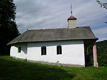
In 1600, the village consisted of 16 serf houses. At the end of the 16th century, Legnava was a medium-sized municipality with exclusively serf population mostly of Rusyn origin. In the 17th century, most land around the village belonged to the Semsey family. The land was later given to the Szirmay family in the 18th century. A chapel built by Tomáš Szirmay (1760) is located 1 km from the village.
By the end of the 19th century, the village had 503 inhabitants, the highest number recorded in the village's history. At that time, the inhabitants made their living mainly by hard labour, such as farming and construction.[5]
Before the establishment of independent Czechoslovakia in 1918, Legnava was part of Sáros County within the Kingdom of Hungary. From 1939 to 1945, it was part of the Slovak Republic. On 24 January 1945, the Red Army dislodged the Wehrmacht from Legnava and it was once again part of Czechoslovakia.
Present

References
- ^ "Počet obyvateľov podľa pohlavia - obce (ročne)". www.statistics.sk (in Slovak). Statistical Office of the Slovak Republic. 2022-03-31. Retrieved 2022-03-31.
- ^ a b "Hustota obyvateľstva - obce [om7014rr_ukaz: Rozloha (Štvorcový meter)]". www.statistics.sk (in Slovak). Statistical Office of the Slovak Republic. 2022-03-31. Retrieved 2022-03-31.
- ^ a b c d "Základná charakteristika". www.statistics.sk (in Slovak). Statistical Office of the Slovak Republic. 2015-04-17. Retrieved 2022-03-31.
- ^ a b "Hustota obyvateľstva - obce". www.statistics.sk (in Slovak). Statistical Office of the Slovak Republic. 2022-03-31. Retrieved 2022-03-31.
- ^ "Legnava". Legnava.eu. Archived from the original on 2013-10-19.
- https://web.archive.org/web/20131019093154/http://legnava.eu/
External links
 Media related to Legnava at Wikimedia Commons
- Official website

- v
- t
- e
Municipalities of Stará Ľubovňa District
- Čirč
- Ďurková
- Forbasy
- Hajtovka
- Haligovce
- Hniezdne
- Hraničné
- Hromoš
- Chmeľnica
- Jakubany
- Jarabina
- Kamienka
- Kolačkov
- Kremná
- Kyjov
- Lacková
- Legnava
- Lesnica
- Litmanová
- Lomnička
- Ľubotín
- Malý Lipník
- Matysová
- Mníšek nad Popradom
- Nižné Ružbachy
- Nová Ľubovňa
- Obručné
- Orlov
- Plaveč
- Plavnica
- Pusté Pole
- Ruská Voľa nad Popradom
- Starina
- Stráňany
- Sulín
- Šambron
- Šarišské Jastrabie
- Údol
- Veľká Lesná
- Veľký Lipník
- Vislanka
- Vyšné Ružbachy


