List of Category A listed buildings in Inverclyde

Map all coordinates using OpenStreetMap
Download coordinates as:
- KML
- GPX (all coordinates)
- GPX (primary coordinates)
- GPX (secondary coordinates)
This is a list of Category A listed buildings in the Inverclyde council area in west-central Scotland.
In Scotland, the term listed building refers to a building or other structure officially designated as being of "special architectural or historic interest".[1] Category A structures are those considered to be "buildings of national or international importance, either architectural or historic, or fine little-altered examples of some particular period, style or building type."[2] Listing was begun by a provision in the Town and Country Planning (Scotland) Act 1947, and the current legislative basis for listing is the Planning (Listed Buildings and Conservation Areas) (Scotland) Act 1997.[3] The authority for listing rests with Historic Scotland, an executive agency of the Scottish Government, which inherited this role from the Scottish Development Department in 1991. Once listed, severe restrictions are imposed on the modifications allowed to a building's structure or its fittings. Listed building consent must be obtained from local authorities prior to any alteration to such a structure.[3] There are approximately 47,400 listed buildings in Scotland, of which around 8% (some 3,800) are Category A.[4]
The council area of Inverclyde covers 160 square kilometres (62 sq mi), and has a population of around 79,800. There are 25 Category A listed buildings in the area.
Listed buildings
| Name | Location | Date Listed | Grid Ref. [note 1] | Geo-coordinates | Notes | LB Number [note 2] | Image |
|---|---|---|---|---|---|---|---|
| St Columba's Church | Kilmacolm, Duchal Road | NS3582469766 | 55°53′35″N 4°37′37″W / 55.892949°N 4.626969°W / 55.892949; -4.626969 (St Columba's Church) | [5] | 12448 |  Upload another image | |
| Windyhill | Kilmacolm, Rowantreehill Road | NS3622269431 | 55°53′24″N 4°37′13″W / 55.890078°N 4.620409°W / 55.890078; -4.620409 (Windyhill) | [6] | 12450 | 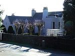 Upload another image | |
| Duchal House | Strathgryfe, Kilmacolm | NS3534468012 | 55°52′37″N 4°38′01″W / 55.877042°N 4.633569°W / 55.877042; -4.633569 (Duchal House) | [7] | 12463 |  Upload Photo | |
| Wemyss Bay Railway Station | Wemyss Bay | NS1933868544 | 55°52′34″N 4°53′22″W / 55.87608°N 4.889427°W / 55.87608; -4.889427 (Wemyss Bay Railway Station) | [8] | 12473 |  Upload another image | |
| Ardgowan House | Inverkip | NS2075073039 | 55°55′01″N 4°52′12″W / 55.916944°N 4.869867°W / 55.916944; -4.869867 (Ardgowan House) | [9] | 12480 |  Upload another image | |
| Finlaystone House | Langbank, Port Glasgow Road | NS3645873717 | 55°55′43″N 4°37′09″W / 55.928627°N 4.619233°W / 55.928627; -4.619233 (Finlaystone House) | [10] | 13641 |  Upload another image | |
| Tontine Hotel | Greenock, Ardgowan Square | NS2727776751 | 55°57′10″N 4°46′05″W / 55.952644°N 4.76794°W / 55.952644; -4.76794 (Tontine Hotel) | [11] | 34078 | 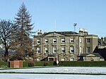 Upload another image | |
| Wellpark Mid Kirk | Greenock, Cathcart Square | NS2797176111 | 55°56′50″N 4°45′23″W / 55.94715°N 4.756431°W / 55.94715; -4.756431 (Wellpark Mid Kirk) | [12] | 34096 |  Upload another image | |
| Custom House | Greenock, Custom House Place | NS2830876204 | 55°56′53″N 4°45′04″W / 55.948105°N 4.7511°W / 55.948105; -4.7511 (Custom House) | [13] | 34100 |  Upload another image | |
| Municipal Buildings | Greenock, Clyde Square | NS2798776208 | 55°56′53″N 4°45′22″W / 55.948026°N 4.756237°W / 55.948026; -4.756237 (Municipal Buildings) | [14] | 34122 |  Upload another image | |
| St Luke's Church (formerly The Old Kirk) | Greenock, Nelson Street | NS2733876341 | 55°56′56″N 4°46′00″W / 55.948987°N 4.766702°W / 55.948987; -4.766702 (St Luke's Church (formerly The Old Kirk)) | [15] | 34134 | 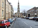 Upload another image | |
| Sir Gabriel Wood's Mariners' Asylum | Greenock, Newark Street | NS2609677538 | 55°57′33″N 4°47′15″W / 55.959129°N 4.787527°W / 55.959129; -4.787527 (Sir Gabriel Wood's Mariners' Asylum) | [16] | 34136 |  Upload another image | |
| Finnart - St Paul's Church | Greenock, Newark Street | NS2646077449 | 55°57′31″N 4°46′53″W / 55.958614°N 4.781457°W / 55.958614; -4.781457 (Finnart - St Paul's Church) | [17] | 34139 |  Upload another image | |
| Watt Library and Mclean Museum | Greenock, Union Street | NS2738376551 | 55°57′03″N 4°45′58″W / 55.950888°N 4.766116°W / 55.950888; -4.766116 (Watt Library and Mclean Museum) | [18] | 34148 |  Upload another image | |
| Well Park: Well | Greenock, Well Park, Well | NS2808975979 | 55°56′46″N 4°45′16″W / 55.946007°N 4.754459°W / 55.946007; -4.754459 (Well Park: Well) | [19] | 34166 |  Upload another image | |
| Sugar Warehouse | Greenock, James Watt Dock | NS2982875528 | 55°56′33″N 4°43′35″W / 55.942579°N 4.726363°W / 55.942579; -4.726363 (Sugar Warehouse) | [20] | 34172 |  Upload another image | |
| St Patrick's RC Church and Presbytery | Greenock, Orangefield | NS2712476086 | 55°56′48″N 4°46′12″W / 55.946621°N 4.769961°W / 55.946621; -4.769961 (St Patrick's RC Church and Presbytery) | [21] | 34173 | 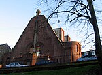 Upload another image | |
| Titan Cantilever Crane | Greenock, James Watt Dock | NS2957475685 | 55°56′38″N 4°43′50″W / 55.943898°N 4.730524°W / 55.943898; -4.730524 (Titan Cantilever Crane) | [22] | 34175 |  Upload another image | |
| St Laurence's RC Church and Presbytery | Greenock, Kilmacolm Road | 23 September 1994 | NS2859775289 | 55°56′24″N 4°44′45″W / 55.939997°N 4.745897°W / 55.939997; -4.745897 (St Laurence's RC Church and Presbytery) | [23] | 34184 | 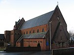 Upload another image |
| Gourock Ropeworks | Port Glasgow | NS3257074414 | 55°56′01″N 4°40′55″W / 55.933544°N 4.681821°W / 55.933544; -4.681821 (Gourock Ropeworks) | [24] | 40067 |  Upload another image | |
| Newark Castle | Port Glasgow | NS3281374520 | 55°56′04″N 4°40′41″W / 55.93458°N 4.678002°W / 55.93458; -4.678002 (Newark Castle) | [25] | 40069 |  Upload another image | |
| Former Municipal Buildings | Port Glasgow, Fore Street | NS3221974560 | 55°56′05″N 4°41′15″W / 55.934732°N 4.687524°W / 55.934732; -4.687524 (Former Municipal Buildings) | [26] | 40071 |  Upload another image | |
| Broadfield Hospital, Broadstone House | Port Glasgow, Old Greenock Road | NS3494773754 | 55°55′42″N 4°38′36″W / 55.928442°N 4.643412°W / 55.928442; -4.643412 (Broadfield Hospital, Broadstone House) | [27] | 40078 |  Upload another image | |
| Holy Family Roman Catholic Church and Presbytery | Port Glasgow, Parkhill Avenue | NS3399473809 | 55°55′43″N 4°39′31″W / 55.928608°N 4.658681°W / 55.928608; -4.658681 (Holy Family Roman Catholic Church and Presbytery) | [28] | 40088 |  Upload another image | |
| Scott's Dry Dock with Outer Basin | Greenock | NS2871675785 | 55°56′40″N 4°44′40″W / 55.94449°N 4.744309°W / 55.94449; -4.744309 (Scott's Dry Dock with Outer Basin) | [29] | 50131 | 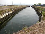 Upload another image |
Notes
- ^ Sometimes known as OSGB36, the grid reference (where provided) is based on the British national grid reference system used by the Ordnance Survey.
• "Guide to National Grid". Ordnance Survey. Retrieved 12 December 2007.
• "Get-a-map". Ordnance Survey. Retrieved 17 December 2007. - ^ Historic Environment Scotland assign a unique alphanumeric identifier to each designated site in Scotland, for listed buildings this always begins with "LB", for example "LB12345".
References
- ^ Guide to the Protection of Scotland’s Listed Buildings (PDF). Historic Scotland. 2009. p. 4. ISBN 978-1-84917-013-0. Retrieved 5 May 2010.
- ^ "What is Listing?". Historic Scotland. Retrieved 5 May 2010.
- ^ a b Scottish Historic Environment Policy (PDF). Historic Scotland. October 2008. pp. 24–25. ISBN 978-1-84917-002-4. Retrieved 5 May 2010.
- ^ Guide to the Protection of Scotland’s Listed Buildings, p. 17.
- ^ "St. Columba's (Formerly St. James's) Church Of Scotland Duchal Road, Kilmacolm: Listed Building Report". Historic Scotland.
- ^ "Windyhill, Rowantreehill Road Kilmacolm: Listed Building Report". Historic Scotland.
- ^ "Duchal House, Strathgryfe, By Kilmacolm: Listed Building Report". Historic Scotland.
- ^ "Wemyss Bay Railway Station: Listed Building Report". Historic Scotland.
- ^ "Ardgowan House, Inverkip.: Listed Building Report". Historic Scotland.
- ^ "Finlaystone House, Port Glasgow Road, By Langbank: Listed Building Report". Historic Scotland.
- ^ "Tontine Hotel, 5 Ardgowan Square: Listed Building Report". Historic Scotland.
- ^ "Wellpark Mid Kirk, Cathcart Square: Listed Building Report". Historic Scotland.
- ^ "Custom House, Custom House Place: Listed Building Report". Historic Scotland.
- ^ "Municipal Buildings, Clyde Square ( Wallace Place/Dalrymple Street): Listed Building Report". Historic Scotland.
- ^ "St Lukes Church Of Scotland, Nelson Street, (Formerly The Old Kirk): Listed Building Report". Historic Scotland.
- ^ "Sir Gabriel Wood's Mariners' Home, Newark Street (Including Front Wall Gate Etc): Listed Building Report". Historic Scotland.
- ^ "Finnart - St Paul's Church Newark Street: Listed Building Report". Historic Scotland.
- ^ "Watt Library And Mclean Museum Union Street, Kelly Street And Watt Street: Listed Building Report". Historic Scotland.
- ^ "Well Park: Well: Listed Building Report". Historic Scotland.
- ^ "Warehouse (Clyde Port Authority) East Hamilton Street, Cartsdyke: Listed Building Report". Historic Scotland.
- ^ "St Patrick's Rc Church And Presbytery, Orangefield And Holmscroft Street: Listed Building Report". Historic Scotland.
- ^ "Greenock, James Watt Dock, Titan Cantilever Crane: Listed Building Report". Historic Scotland.
- ^ "Kilmalcolm Road, St Laurence's Rc Church And Presbytery: Listed Building Report". Historic Scotland.
- ^ "Bay Street/Robert Street, Gourock Ropeworks: Listed Building Report". Historic Scotland.
- ^ "Newark Castle, Castle Street: Listed Building Report". Historic Scotland.
- ^ "Fore Street, Former Municipal Buildings: Listed Building Report". Historic Scotland.
- ^ "Broadfield Hospital, Broadstone House, (Mental Home) Old Greenock Road.: Listed Building Report". Historic Scotland.
- ^ "2 Parkhill Avenue, Holy Family Roman Catholic Church And Presbytery: Listed Building Report". Historic Scotland.
- ^ "Scott's Dry Dock With Outer Basin: Listed Building Report". Historic Scotland.
External links
![]() Media related to Category A listed buildings in Inverclyde at Wikimedia Commons
Media related to Category A listed buildings in Inverclyde at Wikimedia Commons
- v
- t
- e
- City of Aberdeen
- Aberdeenshire
- Angus
- Argyll and Bute
- Clackmannanshire
- Dumfries and Galloway
- City of Dundee
- East Ayrshire
- East Dunbartonshire
- East Lothian
- East Renfrewshire
- City of Edinburgh
- Falkirk
- Fife
- City of Glasgow
- Highland
- Inverclyde
- Midlothian
- Moray
- North Ayrshire
- North Lanarkshire
- Orkney
- Perth and Kinross
- Renfrewshire
- Scottish Borders
- Shetland
- South Ayrshire
- South Lanarkshire
- Stirling
- West Dunbartonshire
- West Lothian
- Western Isles (na h-Eileanan Siar)


