List of listed buildings in Balmaghie, Dumfries and Galloway
This is a list of listed buildings in the parish of Balmaghie, Dumfries and Galloway, Scotland.
Map all coordinates using OpenStreetMap
Download coordinates as:
- KML
- GPX (all coordinates)
- GPX (primary coordinates)
- GPX (secondary coordinates)
List
| Name | Location | Date Listed | Grid Ref. [note 1] | Geo-coordinates | Notes | LB Number [note 2] | Image |
|---|---|---|---|---|---|---|---|
| Hensol Lodge And Gates | 55°00′26″N 4°05′25″W / 55.007198°N 4.090218°W / 55.007198; -4.090218 (Hensol Lodge And Gates) | Category B | 3417 |  Upload Photo | |||
| Glentoo Farmhouse And Horsemill With Steading | 54°56′10″N 4°01′17″W / 54.936171°N 4.021293°W / 54.936171; -4.021293 (Glentoo Farmhouse And Horsemill With Steading) | Category B | 3423 | Upload Photo | |||
| Laurieston, Crockett Memorial | 54°57′44″N 4°03′32″W / 54.96226°N 4.058984°W / 54.96226; -4.058984 (Laurieston, Crockett Memorial) | Category C(S) | 3426 | Upload Photo | |||
| Laurieston, Windhover And Lilac Grove | 54°57′40″N 4°03′35″W / 54.961051°N 4.059781°W / 54.961051; -4.059781 (Laurieston, Windhover And Lilac Grove) | Category C(S) | 3427 | Upload Photo | |||
| Laurieston Hall Stables | 54°58′07″N 4°04′04″W / 54.96859°N 4.067823°W / 54.96859; -4.067823 (Laurieston Hall Stables) | Category B | 3424 | Upload Photo | |||
| Laurieston, Chestnut House | 54°57′39″N 4°03′35″W / 54.960874°N 4.059601°W / 54.960874; -4.059601 (Laurieston, Chestnut House) | Category B | 3425 | Upload Photo | |||
| Gordon Chapel, Quarter Mile West Of Glenlochar Bridge | 54°57′28″N 3°59′27″W / 54.957788°N 3.990734°W / 54.957788; -3.990734 (Gordon Chapel, Quarter Mile West Of Glenlochar Bridge) | Category B | 3414 | Upload Photo | |||
| Laurieston Hall | 54°58′07″N 4°04′11″W / 54.968475°N 4.069801°W / 54.968475; -4.069801 (Laurieston Hall) | Category B | 3418 | Upload Photo | |||
| Little Duchrae, Cottage And Farm Steading | 54°59′51″N 4°05′07″W / 54.997467°N 4.085334°W / 54.997467; -4.085334 (Little Duchrae, Cottage And Farm Steading) | Category C(S) | 3428 | Upload Photo | |||
| Threave Castle | 54°56′21″N 3°58′11″W / 54.939213°N 3.969598°W / 54.939213; -3.969598 (Threave Castle) | Category A | 3408 |  Upload another image | |||
| Hensol House | 55°00′19″N 4°04′20″W / 55.005401°N 4.072297°W / 55.005401; -4.072297 (Hensol House) | Category A | 3415 | 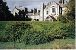 Upload another image | |||
| Hensol House, The Lainshaw Sundial | 55°00′19″N 4°04′19″W / 55.005147°N 4.071909°W / 55.005147; -4.071909 (Hensol House, The Lainshaw Sundial) | Category A | 3416 | Upload Photo | |||
| Balmaghie Parish Church And Churchyard, Church Of Scotland | 54°58′30″N 3°59′49″W / 54.97505°N 3.997026°W / 54.97505; -3.997026 (Balmaghie Parish Church And Churchyard, Church Of Scotland) | Category B | 3422 |  Upload another image | |||
| Livingston | 54°59′13″N 4°00′37″W / 54.986975°N 4.010201°W / 54.986975; -4.010201 (Livingston) | Category B | 3407 | Upload Photo |
Key
The scheme for classifying buildings in Scotland is:
- Category A: "buildings of national or international importance, either architectural or historic; or fine, little-altered examples of some particular period, style or building type."[1]
- Category B: "buildings of regional or more than local importance; or major examples of some particular period, style or building type, which may have been altered."[1]
- Category C: "buildings of local importance; lesser examples of any period, style, or building type, as originally constructed or moderately altered; and simple traditional buildings which group well with other listed buildings."[1]
In March 2016 there were 47,288 listed buildings in Scotland. Of these, 8% were Category A, and 50% were Category B, with the remaining 42% being Category C.[2]
Notes
- ^ Sometimes known as OSGB36, the grid reference (where provided) is based on the British national grid reference system used by the Ordnance Survey.
• "Guide to National Grid". Ordnance Survey. Retrieved 12 December 2007.
• "Get-a-map". Ordnance Survey. Retrieved 17 December 2007. - ^ Historic Environment Scotland assign a unique alphanumeric identifier to each designated site in Scotland, for listed buildings this always begins with "LB", for example "LB12345".
References
- All entries, addresses and coordinates are based on data from Historic Scotland. This data falls under the Open Government Licence
- ^ a b c "What is Listing?". Historic Environment Scotland. Retrieved 29 May 2018.
- ^ Scotland's Historic Environment Audit 2016 (PDF). Historic Environment Scotland and the Built Environment Forum Scotland. pp. 15–16. Retrieved 29 May 2018.
- v
- t
- e
- Annan
- Applegarth
- Caerlaverock
- Canonbie
- Closeburn
- Cummertrees
- Dalton
- Dornock
- Dryfesdale
- Dumfries
- Dunscore
- Durisdeer
- Eskdalemuir
- Ewes
- Glencairn
- Gretna
- Half Morton
- Hoddom
- Holywood
- Hutton and Corrie
- Johnstone
- Keir
- Kirkconnel
- Kirkmahoe
- Kirkmichael
- Kirkpatrick-Fleming
- Kirkpatrick-Juxta
- Langholm
- Lochmaben
- Lockerbie
- Middlebie
- Moffat
- Morton
- Mouswald
- Penpont
- Ruthwell
- Sanquhar
- St Mungo
- Tinwald
- Torthorwald
- Tundergarth
- Tynron
- Wamphray
- Westerkirk
- Anwoth
- Balmaclellan
- Balmaghie
- Borgue
- Buittle
- Carsphairn
- Castle Douglas
- Colvend and Southwick
- Crossmichael
- Dalbeattie
- Dalry
- Gatehouse of Fleet
- Girthon
- Kells
- Kelton
- Kirkbean
- Kirkcudbright
- Kirkgunzeon
- Kirkmabreck
- Kirkpatrick Durham
- Kirkpatrick Irongray
- Lochrutton
- Minnigaff
- New Abbey
- New Galloway
- Newton Stewart
- Parton
- Rerrick
- Terregles
- Tongland
- Troqueer
- Twynholm
- Urr


