Lumle
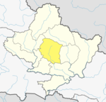
Place in Gandaki Zone, Nepal
Lumle लुम्ले | |
|---|---|
VDC Hill station | |
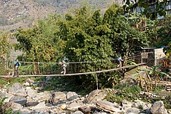 Bridge over Dhoti Khola | |
28°21′N 83°50′E / 28.35°N 83.83°E / 28.35; 83.83 | |
| Country |  Nepal Nepal |
| Zone | Gandaki Zone |
| District | Kaski District |
| Population (1991) | |
| • Total | 4,685 |
| Time zone | UTC+5:45 (NST) |
| Area code | 061 |


Lumle is a town and Annapurna Rural Municipality, Kaski Kaski District in the Gandaki Zone of northern-central Nepal.[clarification needed] At the 1991 Nepal census, it had a population of 4,685 persons in 955 individual households.[1]
Lumle is well known for its agricultural centre on a hillside above the village founded in 1968 to train British Gurkha ex-servicemen farmers. Its role was expanded in 1975 to benefit the communities from which Gurkhas were recruited in Mid-West Hills. It is now part of Nepal Agricultural Research Council.[2]
Localities
- Tanchowk
Educational institutions in Lumle
- Balmandir Community School (community)
- Future Star English Boarding School (private)
- Shree Siddha Lower Secondary School (government)
- Shree Sangam Secondary School (government)
- Srijana Secondary School (government)
- Shree Paudurkot Lower Secondary School (government)
Climate
| Climate data for Lumle, elevation 1,738 m (5,702 ft), (1991–2020) | |||||||||||||
|---|---|---|---|---|---|---|---|---|---|---|---|---|---|
| Month | Jan | Feb | Mar | Apr | May | Jun | Jul | Aug | Sep | Oct | Nov | Dec | Year |
| Mean daily maximum °C (°F) | 13.9 (57.0) | 15.8 (60.4) | 19.8 (67.6) | 22.8 (73.0) | 23.5 (74.3) | 24.0 (75.2) | 23.8 (74.8) | 23.9 (75.0) | 23.3 (73.9) | 21.6 (70.9) | 18.4 (65.1) | 15.2 (59.4) | 20.5 (68.9) |
| Daily mean °C (°F) | 9.3 (48.7) | 11.2 (52.2) | 14.7 (58.5) | 17.6 (63.7) | 18.9 (66.0) | 20.4 (68.7) | 20.8 (69.4) | 20.8 (69.4) | 19.9 (67.8) | 17.3 (63.1) | 13.9 (57.0) | 10.7 (51.3) | 16.3 (61.3) |
| Mean daily minimum °C (°F) | 4.7 (40.5) | 6.5 (43.7) | 9.5 (49.1) | 12.4 (54.3) | 14.3 (57.7) | 16.7 (62.1) | 17.8 (64.0) | 17.6 (63.7) | 16.5 (61.7) | 12.9 (55.2) | 9.3 (48.7) | 6.1 (43.0) | 12.0 (53.6) |
| Average precipitation mm (inches) | 34.9 (1.37) | 51.4 (2.02) | 68.5 (2.70) | 122.8 (4.83) | 309.4 (12.18) | 866.0 (34.09) | 1,473.2 (58.00) | 1,419.4 (55.88) | 903.2 (35.56) | 208.0 (8.19) | 19.7 (0.78) | 15.5 (0.61) | 5,492 (216.22) |
| Source: Department of Hydrology and Meteorology[3] | |||||||||||||
References
- ^ "Nepal Census 2001". Nepal's Village Development Committees. Digital Himalaya. Archived from the original on 12 October 2008. Retrieved 30 September 2008.
- ^ "Welcome | NARC Nepal". narcnepal.org. Retrieved 3 February 2024.
- ^ "PRECIPITATION NORMAL (MM) (1991-2020)" (PDF). Department of Hydrology and Meteorology. Archived from the original (PDF) on 14 October 2023. Retrieved 14 October 2023.
External links
- UN map of the municipalities of Kaski District
- v
- t
- e
Kaski District
Headquarters: Pokhara
- Pokhara
- Arba Vijaya
- Armala
- Begnas
- Bhachok
- Bhadaure Tamagi
- Bhalam
- Bharat Pokhari
- Chapakot
- Dangsing
- Deurali
- Dhampus
- Dhikur Pokhari
- Dhital
- Ghachok
- Ghandruk
- Hansapur
- Hemja
- Kahun
- Kalika
- Kaskikot
- Kristinachnechaur
- Lahachok
- Lamachaur
- Lekhnath Municipality
- Lumle
- Lwangghale
- Machhapuchchhre
- Majhthana
- Mala
- Mauja
- Mijuredanda
- Namarjung
- Nirmalpokhari
- Parche
- Pumdibhumdi
- Puranchaur
- Rakhi
- Ribhan
- Rupakot
- Saimarang
- Salyan
- Sarangkot
- Sardikhola
- Shisuwa
- Siddha
- Sildujure
- Thumakodada
- Thumki
 | This article about a location in the Kaski District of Nepal is a stub. You can help Wikipedia by expanding it. |
- v
- t
- e


