Nahta Cone
Cinder cone in British Columbia, Canada


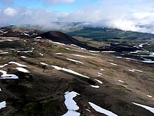
Nahta Cone
Location in British Columbia
 Location in Mount Edziza Provincial Park
Nahta Cone is a small cinder cone in Cassiar Land District of northwestern British Columbia, Canada. It has an elevation of 1,670 metres (5,480 feet) and lies near the northern edge of the Arctic Lake Plateau, a glacially scored plateau of the Tahltan Highland which in turn extends along the western side of the Stikine Plateau. The cone is about 70 kilometres (43 miles) south-southeast of the community of Telegraph Creek and lies in the southwestern corner of Mount Edziza Provincial Park, one of the largest provincial parks in British Columbia.
Nahta Cone is part of the Mount Edziza volcanic complex which has been active episodically for the last 7.5 million years. The summit of the cone contains a circular crater breached on the east that was the source of a roughly 3-kilometre-long (1.9-mile) lava flow that travelled northerly and then westerly into the head of Nahta Creek. Ejecta from the volcano extends about 500 metres (1,600 feet) to the west and 700 metres (2,300 feet) to the north. Access to this isolated volcanic cone is limited to float plane or helicopter.
Geography
Nahta Cone is located in Cassiar Land District of northwestern British Columbia, Canada, near the northern edge of the Arctic Lake Plateau.[3][6][7] It has an elevation of 1,670 metres (5,480 feet) and rises about 60 metres (200 feet) above the glacially scored surface of the plateau to a circular crater breached on the east.[1][6] The cone is surrounded by Mess Creek valley to the west, Wetalth Ridge and Little Arctic Lake to the east, Tadekho Hill to the northeast, Exile Hill to the north and Arctic Lake to the south.[3] Between Nahta Cone and Tadekho Hill is Nahta Creek which flows west through a valley into Mess Creek, a northwest-flowing tributary of the Stikine River.[5][8]
Nahta Cone lies in the southwestern corner of Mount Edziza Provincial Park about 70 kilometres (43 miles) south-southeast of the community of Telegraph Creek.[3] With an area of 266,180 hectares (657,700 acres), Mount Edziza Provincial Park is one of the largest provincial parks in British Columbia and was established in 1972 to preserve the volcanic landscape.[9][10] It also includes the Spectrum Range to the northeast and Mount Edziza further to the north which are separated by the broad east–west valley of Raspberry Pass.[10][11] Mount Edziza Provincial Park is in the Tahltan Highland, a southeast-trending upland area extending along the western side of the Stikine Plateau.[3][12]
Geology
Nahta Cone is the southernmost cinder cone of the Big Raven Formation, the youngest and least voluminous geological formation of the Mount Edziza volcanic complex which has been the focus of episodic volcanism for the last 7.5 million years.[13][14][15] It formed on top of a limestone hill that overlies a contact between Early Devonian granitic rocks and Early Carboniferous volcanic rocks of the Stikine Assemblage, the oldest exposed stratified rocks of the Stikinia terrane which accreted to the continental margin of North America during the Jurassic.[16][17][18] Five tiny hawaiite conelets consisting of black and brick-red scoria blocks comprise Nahta Cone; the hawaiite contains phenocrysts of olivine and plagioclase.[5][6][17] Nahta Cone is somewhat older than The Ash Pit in the Mess Lake Lava Field which may be the youngest cinder cone of the Mount Edziza volcanic complex.[19]
The formation of Nahta Cone was accompanied by the deposition of air-fall tephra and the effusion of a roughly 3-kilometre-long (1.9-mile) lava flow that travelled northerly and then westerly into the head of Nahta Creek.[5][6] Erosion has unmodified the blocky surface of the Nahta Cone lava flow but Nahta Creek at its distal end has begun to etch a new channel where it displaced the stream.[6] The air-fall tephra is lapilli-sized and is distributed about 500 metres (1,600 feet) west and 700 metres (2,300 feet) north of the cone, suggesting that Nahta Cone was volcanically active at least twice during different wind conditions.[6][17] A radiocarbon date of 1,340 years was obtained from the lava flow by Canadian volcanologist Jack Souther in 1970.[17]
Name and etymology
The name of the cone was adopted 2 January 1980 on the National Topographic System map 104G/7 after being submitted to the BC Geographical Names office by the Geological Survey of Canada. It means seven in the Tahltan language, referring to the last seven survivors of the Wetalth people who were outcasted or exiled from the Tahltans in times past.[2] Several other features on the Arctic Lake Plateau such as Wetalth Ridge, Outcast Hill, Exile Hill and Tadekho Hill also have names with Tahltan roots that were adopted 2 January 1980.[3][20][21][22][23]
Accessibility
Nahta Cone can be accessed by float plane or helicopter, both of which are available for charter at the communities of Iskut and Dease Lake.[24] Arctic Lake about 7 kilometres (4.3 miles) south of Natha Cone and Little Arctic Lake about 3 kilometres (1.9 miles) east of Nahta Cone are large enough to be used by float-equipped aircraft.[3][24] Landing on Little Arctic Lake with a private aircraft requires a letter of authorization from the BC Parks Stikine Senior Park Ranger.[10]
See also
- List of volcanoes in Canada
- List of Northern Cordilleran volcanoes
- Volcanism of the Mount Edziza volcanic complex
Notes
- ^ The Global Volcanism Program incorrectly spells Nahta as Nahto.[1]
References
- ^ a b c "Spectrum Range: Synonyms & Subfeatures". Global Volcanism Program. Smithsonian Institution. Archived from the original on 2022-09-22. Retrieved 2024-08-28.
- ^ a b c d e f "Nahta Cone". BC Geographical Names. Archived from the original on 2021-10-01. Retrieved 2024-08-27.
- ^ a b c d e f g h i "A 502" (Topographic map). Telegraph Creek, Cassiar Land District, British Columbia (3 ed.). 1:250,000. 104 G (in English and French). Department of Energy, Mines and Resources. 1989. Archived from the original on 2021-05-02. Retrieved 2024-08-27.
- ^ a b "Nahta Cone". Catalogue of Canadian volcanoes. Natural Resources Canada. 2009-03-10. Archived from the original on 2010-12-11. Retrieved 2023-01-29.
- ^ a b c d Souther, J. G. (1988). "1623A" (Geologic map). Geology, Mount Edziza Volcanic Complex, British Columbia. 1:50,000. Cartography by M. Sigouin, Geological Survey of Canada. Energy, Mines and Resources Canada. doi:10.4095/133498.
- ^ a b c d e f Souther 1992, p. 235.
- ^ "Cassiar Land District". BC Geographical Names. Archived from the original on 2018-06-27. Retrieved 2024-08-28.
- ^ "Mess Creek". BC Geographical Names. Archived from the original on 2021-08-20. Retrieved 2022-09-29.
- ^ "Edziza: Photo Gallery". Global Volcanism Program. Smithsonian Institution. Archived from the original on 2021-09-21. Retrieved 2024-07-04.
- ^ a b c "Mount Edziza Provincial Park". BC Parks. Archived from the original on 2023-01-23. Retrieved 2024-07-03.
- ^ Souther 1992, p. 104.
- ^ Holland, Stuart S. (1976). Landforms of British Columbia: A Physiographic Outline (PDF) (Report). Government of British Columbia. p. 49. ASIN B0006EB676. OCLC 601782234. Archived from the original (PDF) on 2018-11-14.
- ^ Souther 1992, p. 214.
- ^ Edwards, Benjamin Ralph (1997). Field, kinetic, and thermodynamic studies of magmatic assimilation in the Northern Cordilleran Volcanic Province, northwestern British Columbia (PhD thesis). University of British Columbia. pp. 10, 11. ISBN 0-612-25005-9.
- ^ Wood, Charles A.; Kienle, Jürgen (1990). Volcanoes of North America: United States and Canada. Cambridge University Press. p. 124. ISBN 0-521-43811-X.
- ^ Souther 1992, pp. 26, 39.
- ^ a b c d Logan, J. M.; Drobe, J. R. (1993). Geology and Mineral Occurrences of the Mess Lake Area (104G/7W) (PDF). Geological Fieldwork 1992 (Report). Paper 1993-1. British Columbia Geological Survey. pp. 141, 147. Archived from the original (PDF) on 2022-03-22. Retrieved 2024-03-03.
- ^ George, S. W. M.; Nelson, J. L.; Alberts, D.; Greig, C. J.; Gehrels, G. E. (2021). "Triassic–Jurassic Accretionary History and Tectonic Origin of Stikinia From U-Pb Geochronology and Lu-Hf Isotope Analysis, British Columbia". Tectonics. 40 (4). American Geophysical Union: 4. doi:10.1029/2020TC006505.
- ^ Souther 1992, pp. 235, 236.
- ^ "Wetalth Ridge". BC Geographical Names. Archived from the original on 2021-10-01. Retrieved 2024-08-28.
- ^ "Outcast Hill". BC Geographical Names. Archived from the original on 2022-10-09. Retrieved 2024-08-28.
- ^ "Exile Hill". BC Geographical Names. Archived from the original on 2021-10-01. Retrieved 2024-08-28.
- ^ "Tadekho Hill". BC Geographical Names. Archived from the original on 2021-10-01. Retrieved 2024-08-28.
- ^ a b Souther 1992, p. 31.
Sources
- Souther, J. G. (1992). The Late Cenozoic Mount Edziza Volcanic Complex, British Columbia. Geological Survey of Canada (Report). Memoir 420. Canada Communication Group. doi:10.4095/133497. ISBN 0-660-14407-7.
External links
- "Nahta Cone". Geographical Names Data Base. Natural Resources Canada.
- v
- t
- e
- The Ash Pit
- Cache Hill
- Camp Hill
- Cinder Cliff
- Cocoa Crater
- Coffee Crater
- Eve Cone
- Exile Hill
- Icefall Cone
- Kana Cone
- Keda Cone
- Klastline Cone
- Mess Lake Cone
- Moraine Cone
- Nahta Cone
- Outcast Hill
- Ridge Cone
- Sidas Cone
- Sleet Cone
- Source Hill
- Storm Cone
- Thaw Hill
- Triplex Cones
- Twin Cone
- Walkout Creek centres
- Williams Cone
- Artifact Creek
- Ball Creek
- Bourgeaux Creek
- Chakima Creek
- Crayke Creek
- Elwyn Creek
- Flyin Creek
- Gerlib Creek
- Kadeya Creek
- Kitsu Creek
- Little Iskut River
- More Creek
- Nagha Creek
- Nido Creek
- Pyramid Creek
- Raspberry Creek
- Sezill Creek
- Shaman Creek
- Sorcery Creek
- Stewbomb Creek
- Tadekho Creek
- Taweh Creek
- Tenchen Creek
- Tennaya Creek
- Tsecha Creek
- Walkout Creek


