National Register of Historic Places listings in Barrington, Rhode Island
The following properties and districts in Barrington, Rhode Island, are on the National Register of Historic Places.
| Bristol | Kent | Newport | Providence | Washington |
This National Park Service list is complete through NPS recent listings posted August 30, 2024.[1]
Map all coordinates using OpenStreetMap
Download coordinates as:
- KML
- GPX (all coordinates)
- GPX (primary coordinates)
- GPX (secondary coordinates)
| [2] | Name on the Register[3] | Image | Date listed[4] | Location | City or town | Description |
|---|---|---|---|---|---|---|
| 1 | Alfred Drowne Road Historic District | 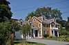 | June 10, 2005 (#05000584) | Alfred Drowne Rd., Annawamscutt Rd., Washington Rd. 41°44′38″N 71°20′38″W / 41.743889°N 71.343889°W / 41.743889; -71.343889 (Alfred Drowne Road Historic District) | Barrington | |
| 2 | Allen-West House |  | December 3, 2013 (#13000887) | 153 George St. 41°46′19″N 71°18′44″W / 41.771912°N 71.31229°W / 41.771912; -71.31229 (Allen-West House) | Barrington | |
| 3 | Barrington Civic Center |  | December 12, 1976 (#76000198) | County Rd. 41°44′29″N 71°18′33″W / 41.741389°N 71.309167°W / 41.741389; -71.309167 (Barrington Civic Center) | Barrington | |
| 4 | Belton Court | 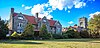 | June 30, 1976 (#76000037) | Middle Highway 41°45′36″N 71°19′57″W / 41.76°N 71.3325°W / 41.76; -71.3325 (Belton Court) | Barrington | |
| 5 | Benjamin Aborn Jackson House |  | September 19, 2008 (#08000903) | 115 Nayatt Rd. 41°43′34″N 71°19′58″W / 41.726133°N 71.332703°W / 41.726133; -71.332703 (Benjamin Aborn Jackson House) | Barrington | |
| 6 | Jennys Lane Historic District |  | March 6, 2008 (#08000152) | Jennys Ln. and Mathewson and Rumstick Rds. 41°44′04″N 71°17′58″W / 41.734541°N 71.299406°W / 41.734541; -71.299406 (Jennys Lane Historic District) | Barrington | |
| 7 | Nayatt Point Lighthouse |  | February 25, 1988 (#87001694) | Nayatt Point 41°43′30″N 71°20′23″W / 41.725°N 71.339722°W / 41.725; -71.339722 (Nayatt Point Lighthouse) | Barrington | |
| 8 | O'Bannon Mill |  | July 23, 1996 (#96000891) | 90 Bay Spring Ave. 41°44′50″N 71°20′43″W / 41.747222°N 71.345278°W / 41.747222; -71.345278 (O'Bannon Mill) | Barrington | |
| 9 | St. Matthew's Episcopal Church | 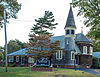 | August 22, 1991 (#91001024) | 5 Chapel Rd. 41°44′34″N 71°20′37″W / 41.742778°N 71.343611°W / 41.742778; -71.343611 (St. Matthew's Episcopal Church) | Barrington |
See also
- National Register of Historic Places listings in Bristol County, Rhode Island
- List of National Historic Landmarks in Rhode Island
References
- ^ National Park Service, United States Department of the Interior, "National Register of Historic Places: Weekly List Actions", retrieved August 30, 2024.
- ^ Numbers represent an alphabetical ordering by significant words. Various colorings, defined here, differentiate National Historic Landmarks and historic districts from other NRHP buildings, structures, sites or objects.
- ^ "National Register Information System". National Register of Historic Places. National Park Service. March 13, 2009.
- ^ The eight-digit number below each date is the number assigned to each location in the National Register Information System database, which can be viewed by clicking the number.
- v
- t
- e
Municipalities and communities of Bristol County, Rhode Island, United States
County seat: Bristol
- Rhode Island portal
- United States portal
| |||||||||||
|---|---|---|---|---|---|---|---|---|---|---|---|
| Topics |  | ||||||||||
| Lists by county | |||||||||||
| Lists by city |
| ||||||||||
| |||||||||||


