National Register of Historic Places listings in Greenlee County, Arizona

This is a list of the National Register of Historic Places listings in Greenlee County, Arizona.
This is intended to be a complete list of the properties and districts on the National Register of Historic Places in Greenlee County, Arizona, United States. The locations of National Register properties and districts for which the latitude and longitude coordinates are included below, may be seen in a map.[1]
There are 10 properties and districts listed on the National Register in the county.
This National Park Service list is complete through NPS recent listings posted August 23, 2024.[2]
Map all coordinates using OpenStreetMap
Download coordinates as:
- KML
- GPX (all coordinates)
- GPX (primary coordinates)
- GPX (secondary coordinates)
Current listings
| [3] | Name on the Register | Image | Date listed[4] | Location | City or town | Description |
|---|---|---|---|---|---|---|
| 1 | Bear Mountain Lookout Complex | Upload image | January 28, 1988 (#87002452) | Apache-Sitgreaves National Forest 33°31′59″N 109°08′38″W / 33.533056°N 109.143889°W / 33.533056; -109.143889 (Bear Mountain Lookout Complex) | Mogollon Rim | |
| 2 | Benjamin F. Billingsley House |  | August 25, 1983 (#83002998) | 202 Main St. 32°43′16″N 109°06′22″W / 32.721103°N 109.106107°W / 32.721103; -109.106107 (Benjamin F. Billingsley House) | Duncan | |
| 3 | Black Gap Bridge |  | September 30, 1988 (#88001627) | Old Safford Rd., 7.8 miles southwest of Clifton 32°56′47″N 109°19′10″W / 32.946495°N 109.319386°W / 32.946495; -109.319386 (Black Gap Bridge) | Clifton | |
| 4 | Clifton Casa Grande Building |  | June 26, 1979 (#79003445) | 8 Park Ave. 33°03′26″N 109°17′56″W / 33.057309°N 109.298765°W / 33.057309; -109.298765 (Clifton Casa Grande Building) | Clifton | |
| 5 | Clifton Townsite Historic District | 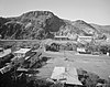 | March 1, 1990 (#90000339) | Confluence of Chase Creek and the San Francisco River 33°03′20″N 109°17′53″W / 33.055556°N 109.298056°W / 33.055556; -109.298056 (Clifton Townsite Historic District) | Clifton | |
| 6 | Gila River Bridge |  | September 30, 1988 (#88001628) | Old Safford Rd., 6.8 miles southeast of Clifton 32°57′55″N 109°18′32″W / 32.965251°N 109.308987°W / 32.965251; -109.308987 (Gila River Bridge) | Clifton | Luten Arch bridge built in 1918. |
| 7 | Park Avenue Bridge |  | September 30, 1988 (#88001661) | Park Ave. over the San Francisco River 33°03′22″N 109°17′55″W / 33.056111°N 109.298611°W / 33.056111; -109.298611 (Park Avenue Bridge) | Clifton | |
| 8 | Dell Potter Ranch House | Upload image | August 3, 1977 (#77000236) | North of Clifton 33°04′57″N 109°18′11″W / 33.0825°N 109.303056°W / 33.0825; -109.303056 (Dell Potter Ranch House) | Clifton | |
| 9 | Solomonville Road Overpass | 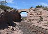 | September 30, 1988 (#88001626) | Old Safford Rd., 3.6 miles south of Clifton 32°59′41″N 109°17′19″W / 32.994711°N 109.288666°W / 32.994711; -109.288666 (Solomonville Road Overpass) | Clifton | |
| 10 | Solomonville Road Overpass | 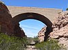 | September 30, 1988 (#88001625) | Old Safford Rd., 4.5 miles south of Clifton 32°58′29″N 109°18′03″W / 32.974763°N 109.300769°W / 32.974763; -109.300769 (Solomonville Road Overpass) | Clifton |
See also
Wikimedia Commons has media related to National Register of Historic Places in Greenlee County, Arizona.
- List of National Historic Landmarks in Arizona
- National Register of Historic Places listings in Arizona
References
- ^ The latitude and longitude information provided in this table was derived originally from the National Register Information System, which has been found to be fairly accurate for about 99% of listings. Some locations in this table may have been corrected to current GPS standards.
- ^ National Park Service, United States Department of the Interior, "National Register of Historic Places: Weekly List Actions", retrieved August 23, 2024.
- ^ Numbers represent an alphabetical ordering by significant words. Various colorings, defined here, differentiate National Historic Landmarks and historic districts from other NRHP buildings, structures, sites or objects.
- ^ The eight-digit number below each date is the number assigned to each location in the National Register Information System database, which can be viewed by clicking the number.
- v
- t
- e
- List of U.S. National Historic Landmarks by state:
- Alabama
- Alaska
- Arizona
- Arkansas
- California
- Colorado
- Connecticut
- Delaware
- Florida
- Georgia
- Hawaii
- Idaho
- Illinois
- Indiana
- Iowa
- Kansas
- Kentucky
- Louisiana
- Maine
- Maryland
- Massachusetts
- Michigan
- Minnesota
- Mississippi
- Missouri
- Montana
- Nebraska
- Nevada
- New Hampshire
- New Jersey
- New Mexico
- New York
- North Carolina
- North Dakota
- Ohio
- Oklahoma
- Oregon
- Pennsylvania
- Rhode Island
- South Carolina
- South Dakota
- Tennessee
- Texas
- Utah
- Vermont
- Virginia
- Washington
- West Virginia
- Wisconsin
- Wyoming
 National Register of Historic Places portal
 Category


| |||
|---|---|---|---|
 | |||
Municipalities and communities of Greenlee County, Arizona, United States | ||
|---|---|---|
County seat: Clifton | ||
| Towns |  | |
| CDPs | ||
| Populated places | ||
| Ghost towns | ||
| ||
Portals:
 Arizona
 NRHP
NRHP


