Pass Cavallo (Texas)
Natural water inlet in Texas, United States
AOL. "Pass Cavallo, Texas" (Map). Mapquest. AOL. Pass Cavallo, alternately known as Cavallo Pass, is one of five natural water inlets which separate the Gulf of Mexico and Matagorda Bay, in the U.S. state of Texas.[1] Matagorda Island Lighthouse was originally built on this site.[2] During the Civil War, Pass Cavallo was a major port of entry and was captured by the Union.[3]
French colonization of Texas
In 1684, René-Robert Cavelier, Sieur de La Salle came ashore on the Texas Gulf Coast at this point establishing the first French colony.[4] In 1686, La Salle's illustrious barque ― La Belle ― navigated the barrier island waterway of the Pass Cavallo.[5]
Illustrations of Pass Cavallo
Pass Cavallo Channel to Matagorda Bay, Texas  Pass Cavallo sketch depicts Texas rebel fortifications and rifle pits at Matagorda Bay, ca. 12/1863 - 01/1864 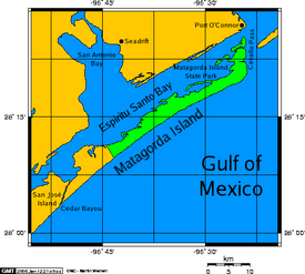 Matagorda Island with illustration of Pass Cavallo |
References
- ^ "Matagorda Bay". Texas A & M University, Corpus Christi. Archived from the original on 24 September 2010. Retrieved 13 September 2011.
- ^ "Matagorda Island Lighthouse - Port O'Connor ~ Marker Number: 23382". Texas Historic Sites Atlas. Texas Historical Commission. 2021. Retrieved 13 September 2011.
- ^ Underwood, Rodman L (2008). Waters of Discord: The Union Blockade of Texas During the Civil War. McFarland. pp. 7, 78, 79. ISBN 978-0-7864-3776-4.
- ^ Sorrells, Colby (2009). Flyfishers Guide to Texas Gulf Coast. Wilderness Adventures Press. p. 131. ISBN 978-1-932098-66-2.
- ^ "La Belle: The Ship That Changed History". The Story of Texas ~ Becoming Texas. Bullock Texas State History Museum.
External links
- "Cavallo Pass". Handbook of Texas Online. Texas State Historical Association.
- Fly over of Pass Cavallo - Port O'Connor Texas on YouTube
- "NOAA Nautical Chart 11319" [Cavallo Pass, Texas]. NOAA Office of Coast Survey. National Oceanic and Atmospheric Administration.
- v
- t
- e
 Waters of Texas
of the Gulf of Mexico
- Alazan Bay
- Aransas Bay
- Baffin Bay
- Carancahua Bay
- Christmas Bay
- Copano Bay
- Corpus Christi Bay
- Dickinson Bay
- East Bay
- East Matagorda Bay
- Espiritu Santo Bay
- Galveston Bay
- Guadalupe Bay
- Laguna Madre
- Lavaca Bay
- Matagorda Bay
- Nueces Bay
- Oso Bay
- Redfish Bay
- Sabine Lake
- San Antonio Bay
- South Bay
- St. Charles Bay
- Tres Palacios Bay
- Trinity Bay
- West Bay
- Acequia Madre de Valero
- American Canal
- Aransas Pass
- Bolivar Roads
- Brazos Santiago Pass
- Cedar Bayou
- Franklin Canal
- Gulf Intracoastal Waterway
- Houston Ship Channel
- Matagorda Ship Channel
- Pass Cavallo
- Port Mansfield Channel
- Riverside Canal
- Sabine Pass
- Sabine–Neches Waterway
- San Luis Pass
- Amistad Reservoir
- Caddo Lake
- Canyon Lake
- Cedar Creek Reservoir
- Choke Canyon Reservoir
- Falcon International Reservoir
- Inks Lake
- Lady Bird Lake
- Lavon Lake
- Lake Austin
- Lake Bardwell
- Lake Buchanan
- Lake Conroe
- Lake Corpus Christi
- Lake Ray Hubbard
- Lake Ray Roberts
- Lake LBJ
- Lake Livingston
- Lake Marble Falls
- Lake Meredith
- Lake Tawakoni
- Lake Texoma
- Lake Travis
- Lewisville Lake
- Richland-Chambers Reservoir
- Sam Rayburn Reservoir
- Toledo Bend Reservoir
- Angelina River
- Blanco River
- Bosque River
- Brazos River
- Buffalo Bayou
- Colorado River
- Concho River
- Canadian River
- Guadalupe River
- James River
- Lampasas River
- Lavaca River
- Leon River
- Little River
- Llano River
- Navidad River
- Neches River
- Nolan River
- Nueces River
- Paluxy River
- Pease River
- Pedernales River
- Prairie Dog Town Fork Red River
- Red River
- Rio Grande
- Devils River
- Pecos River
- Sabine River
- San Antonio River
- San Bernard River
- San Gabriel River
- San Jacinto River
- San Marcos River
- San Saba River
- Sulphur River
- Trinity River
- Wichita River
- White River
- Big Cypress Bayou
- Cow Bayou
- Ottine wetlands
- Rincon Bayou
- Rio Grande Valley


 Pass_Cavallo