Peddocks Island
Island in Boston Harbor


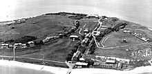
Peddocks Island is one of the largest islands in Boston Harbor.[1] Since 1996 it has formed part of the Boston Harbor Islands National Recreation Area. Managed by the Department of Conservation and Recreation, the island is home to the now-defunct Fort Andrews, active in harbor defense from 1904 to the end of World War II, on its eastern end, and a group of privately owned cottages on its western end.[2] Campsites are also on the eastern end. Ferry service between Peddocks Island and Georges Island (where Fort Warren stands) is provided on a seasonal basis.
Topography
Peddocks Island lies across Hull Gut from the Pemberton neighborhood of Hull to the north and across West Gut to Nut Island & Houghs Neck to the west. The island is located at 42° 17' 32.6" North latitude and 70° 56' 21.6" West longitude. The area of the island is 210.4 acres (0.851 km2), its total acreage at low tide is 288, and its highest elevation is 80 feet. Boasting the longest island shoreline in Boston Harbor, Peddocks Island comprises four headlands connected by gravel or sand bars known as tombolos.[3]
History

One of many Boston Harbor Islands inhabited by Native Americans prior to European settlement in America, Peddock's Island was primarily used for farming since 1634. Its closeness to mainland Boston enabled its use for military purposes as well. During the American Revolutionary War, more than 600 militiamen were stationed on the island to guard against the return of British troops following their evacuation of Boston by the hand of Gen. George Washington on March 17, 1776. A patriot infantrymen's raid on a Loyalist (Tory) farm is also believed to have taken place on the island.[4]
In 1887, a fishing community, the predecessor to the cottages, started on the island.[5]
In 1904, Fort Andrews was built on the island, and it served as an active harbor defense fort until the end of World War II. As of 2008, 26 of the original buildings of Fort Andrews were still standing — guardhouses, prisoner-of-war barracks, stables, a gymnasium, a firehouse, etc. — although most of them were in decrepit shape and were closed to the public for safety reasons.
In 1993, current cottage owners were granted life tenancy in the park, after which the park would take over the cottages.[5]
In 2008, Peddocks Island was used for filming scenes in Martin Scorsese's Shutter Island, starring Leonardo DiCaprio.[6]
In 2011, Boston granted $7.8 million to renovate the island. This will fund a program in which 11 buildings will be demolished and a further 11 restored, in an attempt to make the island more visitor-friendly as a historical museum and nature reserve. Additionally, walking and hiking trails will be provided, along with tours of the historical buildings.[7]
Natural resources
There is a freshwater marsh on the southern end of Peddocks Island.
Predominant tree and shrub species on the island include maple, birch, oak, pine, poplar, sumac, and apple. The island is also populated with wild roses and poison ivy.[8]
Deer and coyotes are also found on the island.[9]
References
- ^ Treasured Island Boston Globe, May 25, 2008.
- ^ Boston Harbor Islands Department of Conservation and Recreation.
- ^ "Island Facts: Peddocks Island - Boston Harbor Islands National Recreation Area (U.S. National Park Service)".
- ^ "Island Facts: Peddocks Island - Boston Harbor Islands National Recreation Area (U.S. National Park Service)".
- ^ a b "Adrift in Time | Why Peddocks Island is an Island Community Like No Other". 6 April 2020.
- ^ Riglian, Adam (2008-04-14). "DiCaprio, Scorsese filming on Peddocks Island". The Patriot Ledger. GateHouse Media. Archived from the original on 2008-10-27. Retrieved 2008-05-21.
- ^ Ryan, Andrew (20 February 2011). "Shuttered island". Boston.com.
- ^ "Island Facts: Peddocks Island - Boston Harbor Islands National Recreation Area (U.S. National Park Service)".
- ^ "The King of Peddocks Island". 15 August 2020.
- Island Facts: Peddocks Island U.S. National Park Service website
- Peddocks Island wikimapia
External links
Wikimedia Commons has media related to Peddocks Island.
- Boston Harbor Islands National Recreation Area
- Boston Harbor Islands Visitor Guide
- [1]
42°17′32.60″N 70°56′21.60″W / 42.2923889°N 70.9393333°W / 42.2923889; -70.9393333
- v
- t
- e
Islands and peninsulas of Massachusetts
- Abnecotants Island
- Adams Island
- Amrita Island
- Angelica Rock
- Apple Island
- Averills Island
- Bachelor Island
- Bakers Island
- Bar Rock (Scituate)
- Baret Island
- Barton Island
- Bassetts Island
- Bates Island
- Beaver Island
- Big Pine Island
- Big Quamino Rock
- Billingsgate Island
- Bird Island
- Black Rock
- Blueberry Island
- Boston Ledge
- Brant Island
- Brant Rock
- Bumpkin Island
- Busta Rhymes Island
- Button Island
- Calf Island
- Carrick Island
- Castle Rock
- Cemetery Island
- Chappaquiddick Island
- Children's Island
- Childs Island
- Choate Island
- Chubb Island
- Clark Island
- Clark's Island
- Cleveland Island
- Cobble Island
- Coney Island
- Conspiracy Island
- Cormorant Rock (Marblehead)
- Corn Island
- Cove Ledge
- Crow Island
- Crowninshield Island
- Cuttyhunk Island
- Decatur Rock
- Deer Island (Amesbury)
- Dole Island
- Egg Rock (Concord)
- Egg Rock (Nahant)
- Elizabeth Islands
- Fish Island
- Gallops Island
- Georges Island
- Gooseberry Island
- Governors Island
- Grand Island
- Grape Island (Weymouth)
- Grape Island (Ipswich)
- Great Brewster Island
- Green Island
- Gull Island
- Hales Island
- Hangman Island
- Holy Island
- House Island
- Langlee Island
- Little Brewster Island
- Long Island
- Lovells Island
- Marblehead Rock
- Martha's Vineyard
- Middle Brewster Island
- Misery Islands
- Monomoy Island
- Moon Island
- Muskeget Island
- Nahant
- Nantucket
- Nashawena Island
- Naushon Island
- Nixes Mate
- Noddle's Island
- Nomans Land
- Nonamesset Island
- Nut Island
- Onset Island
- Outer Brewster Island
- Pasque Island
- Peddocks Island
- Penikese Island
- Plum Island
- Popponesset Island
- Popponesset Spit
- Raccoon Island
- Ragged Island
- Rainsford Island
- Sampsons Island
- Sarah Island
- Shag Rocks
- Slate Island
- Snake Island
- Spectacle Island
- Spinnaker Island
- Stall Hill Island
- Tewksbury Rock
- Thacher Island
- The Graves
- Thompson Island
- Three and One-half Fathom Ledge
- Tinker's Island
- Tuckernuck Island
- Uncatena Island
- Veckatimest Island
- Washburn Island
- Weepecket Islands
- West Island
- Wickets Island
- Winter Island
- Cape Ann
- Cape Cod
- Castle Island
- Charles River Peninsula
- Charlestown Neck
- Columbia Point
- Deer Island
- Houghs Neck
- Humarock
- Pemberton Point
- Popponesset Peninsula
- Ram Head
- Rocky Point
- Rose Point
- Salem Neck
- Shawmut Peninsula
- Wings Neck
- World's End
Authority control databases | |
|---|---|
| International |
|
| National |
|
| Other |
|


