Queropalca District
District in Huánuco, Peru
Queropalca Qirupallqa | |
|---|---|
District | |
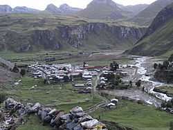 Queropalca | |
| Country |  Peru Peru |
| Region | Huánuco |
| Province | Lauricocha |
| Founded | May 12, 1962 |
| Capital | Queropalca |
| Government | |
| • Mayor | Carlos Enrique Zambrano Santillan |
| Area | |
| • Total | 131.15 km2 (50.64 sq mi) |
| Elevation | 3,831 m (12,569 ft) |
| Population (2005 census) | |
| • Total | 849 |
| • Density | 6.5/km2 (17/sq mi) |
| Time zone | UTC-5 (PET) |
| UBIGEO | 101004 |
Queropalca District is one of seven districts of the province Lauricocha in Peru.[1]
Geography
The Waywash mountain range traverses the district. The highest peak of the district is Yerupaja at 6,635 m (21,768 ft) which is also the highest elevation of the range. Other mountains are listed below:[2]
- Allqay
- Chawpi Hanka
- Chinkana
- Kasha
- Kuntur Waqanan
- Llamt'a
- Mit'urahu
- Parya
- Runtuy
- T'uyu Hirka
See also
- Mit'uqucha
- Ninaqucha
- Qarwaqucha
References
- ^ (in Spanish) Instituto Nacional de Estadística e Informática. Banco de Información Distrital Archived April 23, 2008, at the Wayback Machine. Retrieved April 11, 2008.
- ^ escale.minedu.gob.pe - UGEL map of the Lauricocha Province (Huánuco Region)
- v
- t
- e

- Districts of Huánuco Region
- Peru

- Baños
- Jesús
- Jivia
- Queropalca
- Rondos
- San Francisco de Asís
- San Miguel de Cauri
 | This Huánuco Region geography article is a stub. You can help Wikipedia by expanding it. |
- v
- t
- e
10°10′45″S 76°48′10″W / 10.17917°S 76.80278°W / -10.17917; -76.80278


