Roundway Down and Covert
Hillfort and battle ground in Wiltshire, England
51°22′50″N 2°00′05″W / 51.38045°N 2.00139°W / 51.38045; -2.00139 Scheduled monument
Registered battlefield


Location within Wiltshire
Roundway Down and Covert (grid reference SU000646) is an area of sloping chalk grassland close to the hamlet of Roundway, near Devizes in Wiltshire, England. It is part of the North Wessex Downs Area of Outstanding Natural Beauty. At the summit of the slope are ancient earthworks, evidence of a Bronze Age human settlement and Iron Age hillfort.
During the Civil War, the Battle of Roundway Down was fought here in 1643, and today the hillfort is known locally as "Oliver's Castle" or "Oliver's Camp".[1]
In 1971 the 86-hectare (210-acre) site was notified as a biological Site of Special Scientific Interest.
Hillfort
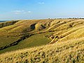
Archaeological remains of a univallate hillfort exist at the top of Roundway Hill, a chalk escarpment. The fortifications are thought to date from between the Late Bronze Age and Early Iron Age (between the eighth and fifth century BC). The site consists of a triangular central area of approximately 1.6 hectares (4.0 acres) enclosed by a single rampart, ditch and counterscarp bank. The north and south sides have steep natural slopes, and so the remains of the main defences are found on the eastern side. Also situated on the summit are two bowl barrows (types of tumuli).[1]
In 1907, the archaeologists Maud Cunnington and Ben Cunnington excavated the site. They found evidence of an older Bronze Age settlement below the hillfort, and artefacts such as Romano-British pottery, antler and animal bone suggested that the site had been a centre of human activity for a prolonged period. Excavations in the bowl barrows revealed evidence of a cremation, along with an incense cup, perforated conical buttons and secondary urn burials, flints, and Bronze Age and Romano-British pottery. Further excavations in 1977 revealed more artefacts, along with evidence that the barrows were at one time incorporated into the hillfort's outer ramparts.[1]
The hillfort was designated a scheduled monument in 1964.[1]
Civil War
During the First English Civil War, Roundway Down became the site of a noted battle. On 13th July 1643, a Royalist cavalry force under Lord Wilmot fought the Parliamentarian Army of the West under Sir William Waller in the Battle of Roundway Down.[2][3]
The Parliamentarian forces were defeated and at the end of the battle, a large number of their fleeing cavalry rode over the 300 feet (91 m) cliff to their deaths. The ditch at the bottom was given the name "Bloody Ditch" as a result of this rout, while the hillfort is now known as "Oliver’s Camp" or "Oliver’s Castle" (after Oliver Cromwell).[2]
Site of Special Scientific Interest
The site was notified as a biological Site of Special Scientific Interest in 1971. The escarpment is noted as a habitat for rare wildflower species such as bastard toadflax, early gentian, field fleawort and round-headed rampion, as well as a range of insects, including over 30 types of butterfly.[4]
Devizes White Horse
To the south-east of Roundway Down on Bank Field is the Devizes Millennium White Horse, a chalk hill figure of a horse which was carved into the hillside in 1999.[5]
Landscape features
-
 View of the hill fort
 -
 Beacon Hill, to the north
 -
 The chalk escarpment
 -
 "Bloody Ditch"
 -
 The Devizes White Horse


Sources
- Natural England citation sheet for the site (accessed 25 May 2023)
References
Wikimedia Commons has media related to Roundway Down and Covert.
- ^ a b c d Historic England. "Oliver's Camp and two round barrows (1005709)". National Heritage List for England. Retrieved 26 October 2017.
- ^ a b "The Battle of Roundway Down, Devizes July 13th, 1643". Devizes Heritage. Archived from the original on 28 February 2012. Retrieved 12 May 2012.
- ^ "English Heritage Battlefield Report: Roundway Down 1643" (PDF). WaybackMachine. Internet Archive. 1995. Archived from the original (PDF) on 14 February 2012. Retrieved 5 August 2020.
- ^ "Roundway Down, Wiltshire". www.uksouthwest.net. Retrieved 19 March 2024.
- ^ Smith, Esther (2004). White Horses of Wiltshire and Uffington: A Complete Guide to the White Horses and Their History. Forward Publications. ISBN 978-0-9544916-1-1.
- v
- t
- e
- Acres Farm Meadow
- River Avon System
- Baverstock Juniper Bank
- Bencroft Hill Meadows
- Bentley Wood
- Bincknoll Dip Woods
- Blackmoor Copse
- Botley Down
- Bowerchalke Downs
- Box Mine
- Bracknell Croft
- Bradley Woods
- Bratton Downs
- Brickworth Down and Dean Hill
- Brimsdown Hill
- Britford Water Meadows
- Burcombe Down
- Burderop Wood
- Calstone and Cherhill Downs
- Camp Down
- Chilmark Quarries
- Chickengrove Bottom
- Chilton Foliat Meadows
- Clattinger Farm
- Clearbury Down
- Cley Hill
- Cloatley Manor Farm Meadows
- Clout's Wood
- Coate Water
- Cockey Down
- Colerne Park and Monk's Wood
- The Coombes, Hinton Parva
- Cotswold Water Park
- Cranborne Chase
- Dank's Down and Truckle Hill
- Distillery Farm Meadows
- East Harnham Meadows
- Ebsbury Down
- Emmett Hill Meadows
- Figsbury Ring
- Fonthill Grottoes
- Fyfield Down
- Gallows Hill
- Goldborough Farm Meadows
- Great Cheverell Hill
- Great Yews
- Gutch Common
- Ham Hill
- Hang Wood
- Harries Ground, Rodbourne
- Haydon Meadow
- Heath Hill Farm
- Homington and Coombe Bissett Downs
- Honeybrook Farm
- Inwood, Warleigh
- Jones's Mill
- River Kennet
- Kennet and Lambourn Floodplain
- King's Play Hill
- Knapp and Barnett's Downs
- Knighton Downs and Wood
- Landford Bog
- Landford Heath
- Langley Wood and Homan's Copse
- Little Grubbins Meadow
- Long Knoll
- Loosehanger Copse and Meadows
- Lower Coombe and Ferne Brook Meadows
- Lower Woodford Water Meadows
- Midford Valley Woods
- Morgan's Hill
- The New Forest
- North Meadow, Cricklade
- Odstock Down
- Out Woods
- Parsonage Down
- Pewsey Downs
- Picket and Clanger Wood
- Piggledene
- Pike Corner
- Pincombe Down
- Porton Down
- Porton Meadows
- Prescombe Down
- Rack Hill
- Ravensroost Wood
- Restrop Farm and Brockhurst Wood
- Rotherley Downs
- Roundway Down and Covert
- Salisbury Plain
- Savernake Forest
- Scratchbury & Cotley Hills
- Silbury Hill
- Spye Park
- Starveall and Stony Down
- Steeple Langford Down
- Stockton Wood and Down
- Stoke Common Meadows
- Stratford Toney Down
- Sutton Lane Meadows
- Throope Down
- River Till
- Tytherington Down
- Upper Waterhay Meadow
- Upton Cow Down
- West Yatton Down
- Whiteparish Common
- Whitesheet Hill
- Win Green Down
- Winklebury Hill
- Winsley Mines
- Wylye and Church Dean Downs
- Yarnbury Castle
- Neighbouring areas
- Avon
- Berkshire
- Dorset
- Gloucestershire
- Hampshire
- Oxfordshire
- Somerset


