Selhurst
Human settlement in England
- London
- Croydon North
- Croydon and Sutton
Selhurst is an area in the London Borough of Croydon, England, 7.8 miles (12.6 km) south-south-east of Charing Cross. Historically it lays in Surrey. The area is bounded to the west and south by Thornton Heath and Croydon and to the east and south by South Norwood and Woodside. Selhurst Park, the home stadium of Crystal Palace Football Club, is sited at the northern end of the neighbourhood.
History
Selhurst is named after the Old English for "dwelling in a wood", or possibly 'dwelling where willows grow'; the name is first recorded in 1225.[2] Saxon coins were found here when the railway station was built.[2] Housing began to be built in the area following the opening of the Croydon Canal in 1809, however the canal proved to be a failure and it closed in 1836.[2] Races were held at Heaver's Farm in the 1850s-60s.[2] Further housing development occurred following the opening of Selhurst train station in 1865.[2]
Demography
White British is the largest ethnic group as of the 2011 census, forming 26% of the population. The second and third largest were Black Caribbean and Black African, both 14% each.[3] 65.5% of the population are of BAME minority background, higher than the Croydon average.
The median house price in Selhurst ward in 2014 was £212,998, which is the 17th lowest out of the 628 wards of Greater London.[4]
Education
The BRIT School, a performing arts school operated by The BRIT foundation, more commonly known for the BRIT Awards, is located in the area.[2]
Transport
Selhurst railway station has frequent trains north to London Victoria, and London Bridge at peak times, and south to Sutton, Caterham and Epsom Downs via East Croydon and West Croydon.[5][6] Selhurst Depot is mainly used by the Southern train operating company, and lies on the site of the former Crystal Palace FC grounds.[2] Selhurst is in Zone 4 of the London Transport Network.
London Bus Route 75 and London Bus Route 157 both run the length of Selhurst Road, terminating at Croydon and Lewisham (75) and Morden and Crystal Palace (157).
Notable residents
- Samuel Coleridge-Taylor (1875–1912), composer, lived at 30 Dagnall Park.[7]
Gallery
-
 Samuel Coleridge-Taylor's House, Dagnall Park
 -
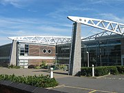 The BRIT School
 -
 Selhurst Park, home of Crystal Palace F.C.
 -
![Selhurst War Memorial, a grade II listed structure[8]](//upload.wikimedia.org/wikipedia/commons/thumb/1/15/Selhurst_War_Memorial_Grade_II_listed.jpg/180px-Selhurst_War_Memorial_Grade_II_listed.jpg) Selhurst War Memorial, a grade II listed structure[8]
Selhurst War Memorial, a grade II listed structure[8] -
![Seventh Day Adventist Church, Selhurst, originally built as a Congregationalist church in 1865[9]](//upload.wikimedia.org/wikipedia/commons/thumb/e/ea/Seventh-day_Adventist_Church%2C_Selhurst.jpg/112px-Seventh-day_Adventist_Church%2C_Selhurst.jpg)
-
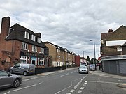 Shops along Northcote Road/Selhurst Road
 -
 King George's Field


![Selhurst War Memorial, a grade II listed structure[8]](http://upload.wikimedia.org/wikipedia/commons/thumb/1/15/Selhurst_War_Memorial_Grade_II_listed.jpg/180px-Selhurst_War_Memorial_Grade_II_listed.jpg)
![Seventh Day Adventist Church, Selhurst, originally built as a Congregationalist church in 1865[9]](http://upload.wikimedia.org/wikipedia/commons/thumb/e/ea/Seventh-day_Adventist_Church%2C_Selhurst.jpg/112px-Seventh-day_Adventist_Church%2C_Selhurst.jpg)


References
- ^ "Croydon Ward population 2011". Neighbourhood Statistics. Office for National Statistics. Retrieved 10 October 2016.
- ^ a b c d e f g Willey, Russ (2006). The London Gazzetteer. Chambers Harrap Publishers Ltd. pp. 433–4.
- ^ "Selhurst". UK Census Data. 2011. Retrieved 25 September 2019.
- ^ "Ward Profiles and Atlas – London Datastore". Retrieved 4 February 2021.
- ^ Body, Geoffrey (1989). PSL field guide to the railways of Southern Region. Wellingborough: Patrick stephens Ltd. p. 171. ISBN 1-85260-297-X.
- ^ Yonge, John (November 2008) [1994]. Jacobs, Gerald (ed.). Railway Track Diagrams 5: Southern & TfL (3rd ed.). Bradford on Avon: Trackmaps. map 14C. ISBN 978-0-9549866-4-3.
- ^ "COLERIDGE-TAYLOR, SAMUEL (1875-1912)". English Heritage. Retrieved 31 August 2020.
- ^ "Selhurst War Memorial". British Listed Buildings. Retrieved 26 September 2019.
- ^ Cleal, Edward E (1908). The Story of Congregationalism in Surrey.
External links
Wikimedia Commons has media related to Selhurst.
- Selhurst Property Guide
- v
- t
- e
- Addington
- Addiscombe
- Beddington
- Broad Green
- Coombe
- Coulsdon
- Croydon
- Crystal Palace
- Forestdale
- Hamsey Green
- Kenley
- Monks Orchard
- New Addington
- Norbury
- Norwood New Town
- Old Coulsdon
- Old Town
- Pollards Hill
- Purley
- Russell Hill
- Sanderstead
- Selhurst
- Selsdon
- Shirley (Including Shirley Oaks and Upper Shirley)
- South Croydon
- South Norwood
- Spring Park
- Thornton Heath
- Upper Norwood
- Waddon
- Woodcote
- Woodside
- Whyteleafe


open spaces
- Addington Hills
- Addington Park
- Addington Vale
- Addiscombe Railway Park
- Addiscombe Recreation Ground
- Apsley Road Playground
- Ashburton Park
- Ashburton Playing Fields
- Beaulieu Heights
- Bramley Bank
- Brickfields Meadow
- Coombe Wood
- Cotelands
- Croham Hurst
- Duppas Hill
- Farthing Downs
- Foxley Wood
- Grangewood Park
- Great North Wood
- Happy Valley Park
- Heathfield House
- Heavers Meadow
- Hutchinson's Bank
- Kenley Common
- Littleheath Woods
- Lloyd Park
- Mitcham Common
- Norwood Grove
- Park Hill
- Pollards Hill
- Queen's Gardens
- Riddlesdown Common
- Roundshaw
- Selsdon Wood
- South Norwood Country Park
- South Norwood Lake and Grounds
- South Norwood Recreation Ground
- Spa Wood
- Wandle Park
- Woodside Green
- Croydon South
- Croydon Central
- Croydon North
- Addiscombe East
- Addiscombe West
- Bensham Manor
- Broad Green
- Coulsdon Town
- Crystal Palace & Upper Norwood
- Fairfield
- Kenley
- New Addington North
- New Addington South
- Norbury & Pollards Hill
- Norbury Park
- Old Coulsdon
- Park Hill & Whitgift
- Purley & Woodcote
- Purley Oaks & Riddlesdown
- Sanderstead
- Selhurst
- Selsdon & Addington Village
- Selsdon Vale & Forestdale
- Shirley North
- Shirley South
- South Croydon
- South Norwood
- Thornton Heath
- Waddon
- West Thornton
- Woodside
and tram stops
- Addington Village
- Addiscombe
- Ampere Way
- Arena
- Blackhorse Lane
- Centrale
- Church Street
- Coombe Lane
- Coulsdon South
- Coulsdon Town
- East Croydon
- Fieldway
- George Street
- Gravel Hill
- Harrington Road
- Kenley
- King Henry's Drive
- Lebanon Road
- Lloyd Park
- New Addington
- Norbury
- Norwood Junction
- Purley Oaks
- Purley
- Reedham
- Reeves Corner
- Riddlesdown
- Sanderstead
- Sandilands
- Selhurst
- South Croydon
- Thornton Heath
- Waddon
- Waddon Marsh
- Wandle Park
- Wellesley Road
- West Croydon
- Woodmansterne
- Woodside
 Category
 Commons


