Sierra de Cucalón


Sierra de Cucalón
Location in Spain
(Aragon)
Sierra de Cucalón is a 25-kilometre (16 mi) long system of mountain ranges in Aragon, Spain, located between the comarcas of Jiloca and Cuencas Mineras.
Geography
These mountains are part of the Iberian System and are often covered with snow in the winter. Rivers Huerva and Martín have their source in these ranges.
The Ermita de la Virgen de Pelarda is located in the Pelarda range, close to Olalla.[1]
Subranges
Two main ranges run parallel to each other, the northern one is Sierra de Oriche, also known as "Las Rochas", and the southern one, smoother and covered with forest, as Sierra de Pelarda or Sierra de la Pelarda (also known as "Sierra de Fonfría" after the town of Fonfría in its central section) extending eastwards as Sierra Pedregosa. This whole system of mountain ranges is named after the town of Cucalón, located at the western end.[2]
The ridge's highest summits are Pelarda (1,517 m), in Sierra de Pelarda, and La Modorra (1,478 m), located at the NW end of the Sierra de Oriche. Other important summits are El Marujal (1,486 m), Cerro del Ortigal (1,429 m), Alto del Puerto de Fonfría (1,501 m), La Rocha (1,340 m) and La Retuerta (1,492 m). All main peaks are inconspicuous except for La Modorra.
Ecology
The Sierra de Pelarda mountains are covered with forest made up pine, Carrasca (Quercus ilex), cork oak, and juniper trees.[3] There are many endangered species living in these relatively uninhabited mountains, far from human intervention.
Features
-
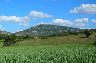 View of La Modorra from Lanzuela
 -
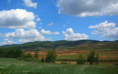 View of Sierra de Pelarda from Bea
 -
 Juniper trees and garbage near Olalla


References
External links
 Media related to Sierra de Cucalón at Wikimedia Commons
- Sierra de Cucalón
- Ascensión a el Pelarda (1512 m)
- Santuario de la Virgen de Pelarda
- v
- t
- e
Mountain ranges of the Sistema Ibérico
- Sierra de la Demanda
- Sierra de Neila
- Mesa de Cebollera
- Picos de Urbión
- Sierra de Alcarama
- Sierra de Peñalmonte
- Sierra de Moncalvillo
- Moncayo
- Sierra de Nava Alta
- Sierra de Perdices
- Sierra Ministra
- Sierra de Caldereros
- Sierra de Pardos
- Sierra de Miñana
- Sierra de Solorio
- Sierra de Selas
- Parameras de Molina
& Southeastern
- Serranía de Cuenca
- Sierra Menera
- Sierra de Albarracín
- Montes de Picaza
- Montes Universales
- Sierra de Mira
- Sierra de Javalambre
- Sierra del Toro
- Sierra de la Virgen
- Sierra de Vicort
- Sierra de Algairén
- Sierra de Santa Cruz
- Sierra de Cucalón
- Sierra de Herrera
- Sierra de San Just
- Sierra de Lidón
- Sierra Palomera
- Sierra de Gúdar
- Sierra de Mayabona
- Sierra de Camarena
- Sierra de Sollavientos
- Sierra del Rayo
- Sierra de Pina
- Maestrat (Maestrazgo)
- Penyagolosa Massif
- Sierra de la Lastra
- Sierra de los Caballos
- Sierra de Garrocha
- Sierra de la Cañada
- Sierra Carrascosa
- Ports de Morella
- Serra de la Creu
- Serra d'En Segures
- Serra d'en Galceran
- Serra d'Esparreguera
- Serra de Vallivana
- Serra d'En Celler
- Serra del Turmell
- Serra de l'Espadella
- Moles de Xert
- Talaies d'Alcalà
- Serra de la Vall d'Àngel
- Cervera Mountains
- Serra de Sant Pere
- Serra Calderona
- Serra d'Espadà
- Ports de Tortosa-Beseit
- Benifassà Mountains
- Serra de Paüls
- Serra de l'Espina
- Moncayo
- Monte San Lorenzo
- Pico de Urbión
- Javalambre
- Peñarroya
- Peña Isasa
- Peñalmonte
- Tetas de Viana
- Caimodorro
- Cerro Calderón
- Monte Gatún
- Monte Serradero
- Mont Caro
- Castell de l'Airosa
- La Moleta
- Montegordo
- Penyagalera
- Roques de Benet
- Santa Bàrbara
- Alto del Buitre
- Tossal d'Orenga
- Tossal dels Tres Reis
 | This article about a location in Aragon, Spain, is a stub. You can help Wikipedia by expanding it. |
- v
- t
- e


