Susquehanna–Dauphin station
Rapid transit station in Philadelphia
| Preceding station |  SEPTA SEPTA | Following station | ||
|---|---|---|---|---|
| Cecil B. Moore toward NRG | Broad Street Line Local | North Philadelphia toward Fern Rock T.C. | ||
Future services (2024) | |||||||||||||||
|---|---|---|---|---|---|---|---|---|---|---|---|---|---|---|---|
| |||||||||||||||

Location | |
|---|---|
 |
Susquehanna–Dauphin station is a subway station on SEPTA's Broad Street Line in Philadelphia, Pennsylvania. The station is located at the 2200 block of North Broad Street in North Philadelphia,[1] between Susquehanna Avenue at the south end and Dauphin Street at the north end.[2] Four tracks travel through the station, however the station is only served by local trains,[1] which travel on the outer two tracks. Along with Cecil B. Moore station, this stop provides access to Temple University, which is located one block south of Susquehanna Avenue.[3] Service began at the station, formerly known as Dauphin–Susquehanna, on September 1, 1928, as part of the original segment of the Broad Street Line, which ran from City Hall station to Olney station.[4]
Until February 25, 1956, Trolley Routes 8 and 39 (now a bus line) service as the stations connections which travels westbound on Susquehanna Avenue to the Strawberry Mansion neighborhood, and eastbound on Dauphin Street to the Kensington neighborhood.[5]
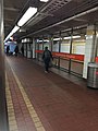
Station layout
Fares are collected at the center of the platforms on each side of the tracks, as there is no crossover built at this station.
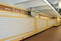
Station mural
The station features a mural entitled City Diary, created by Philadelphia children in 1997. The mural consists of many 8 in2 (20.32 cm2) ceramic tiles, split into two pieces on opposite sides of the station, with lengths of 28 ft (8.53 m) and 19 ft (5.79 m), respectively. Over 170 children between the ages of 6 and 16 contributed to the project, which was dedicated to the station on June 11, 1997.[6]
Gallery
-
 Station entrance
 -
 Platform south
 -
 Platform north
 -
 The platform of the Susquehanna–Dauphin Station
 -
 Center tracks


References
- ^ a b "Broad Street Line Map" (PDF). SEPTA. 2010-09-05. Retrieved 2010-10-30.
- ^ "Susquehanna-Dauphin Station". Google Maps. Retrieved 2007-11-19.
- ^ "Getting Around Philly on Public Transportation". Temple University School of Communications and Theater. Archived from the original on 2007-09-20. Retrieved 2007-11-19.
- ^ "Broad Street Subway". world.nycsubway.org. Retrieved 2007-11-19.
- ^ "SEPTA Route 39 Map" (PDF). SEPTA. 2010-09-05. Retrieved 2010-10-30.
- ^ Rice, Robin. "Platform Party". Philadelphia City Paper. Retrieved 2007-11-19.
External links
![]() Media related to Susquehanna–Dauphin (SEPTA station) at Wikimedia Commons
Media related to Susquehanna–Dauphin (SEPTA station) at Wikimedia Commons
- SEPTA – Susquehanna–Dauphin station
- Dauphin Street entrance from Google Maps Street View
- Susquehanna Avenue entrance from Google Maps Street View
- v
- t
- e
SEPTA rapid transit stations
- 69th Street Transportation Center
- Millbourne
- 63rd Street
- 60th Street
- 56th Street
- 52nd Street
- 46th Street
- 40th Street
- 34th Street
- Drexel Station at 30th Street
- 15th Street
- 13th Street
- 11th Street
- 8th Street
- 5th Street/Independence Hall
- 2nd Street
- Spring Garden
- Girard
- Berks
- York–Dauphin
- Huntingdon
- Somerset
- Allegheny
- Tioga
- Erie–Torresdale
- Church
- Arrott Transportation Center
- Frankford Transportation Center
- Fern Rock Transportation Center
- Olney Transportation Center
- Logan
- Wyoming
- Hunting Park
- Erie
- Allegheny
- North Philadelphia
- Susquehanna–Dauphin
- Cecil B. Moore
- Girard
- Fairmount
- Spring Garden
- Race–Vine
- City Hall
- Walnut–Locust
- Lombard–South
- Ellsworth–Federal
- Tasker–Morris
- Snyder
- Oregon
- NRG
| Broad–Ridge Spur |
|
|---|
High Speed Line
- 69th Street Transportation Center
- Parkview
- Township Line Road
- Penfield
- Beechwood–Brookline
- Wynnewood Road
- Ardmore Junction
- Ardmore Avenue
- Haverford
- Bryn Mawr
- Roberts Road
- Garrett Hill
- Stadium–Ithan Avenue
- Villanova
- Radnor
- County Line
- Matsonford
- Gulph Mills
- Hughes Park
- DeKalb Street
- Bridgeport
- Norristown Transportation Center


