Tunnel de la Croix-Rousse
45°46′26″N 4°49′13″E / 45.77389°N 4.82028°E / 45.77389; 4.82028
 East entrance, Rhone side. | |
| Overview | |
|---|---|
| Location | Lyon, France |
| Operation | |
| Opened | 19 April 1952 |
| Technical | |
| Length | 1,782 m |
The Tunnel de la Croix-Rousse is a pair of two tunnels located in the 1st and 4th arrondissements of Lyon, a road tunnel opened to traffic on 19 April 1952 and a sustainable transport tunnel opened in 2013.
Description
It follows the line of the Route nationale 6 and is a link between the Rhône to the Saône rivers. It crosses the hill of la Croix-Rousse. The roadway was composed of 2 x 2 routes with no real separation of roadways until the construction of a central wall in 1999. Its use is only for vehicles with weights less than 3.5 tonnes. The tunnel length is 1,782 meters.
The speed is limited to 50 km/h (30 km/h when it rains) and an automatic radar used to be located at its exit in the direction Lyon-Vaise.
A separate route for buses, pedestrians and cyclists was opened in 2013.[1] This route is also a safety access to the car tunnel and is illuminated with colored lights, and video displays and music are played as entertainment for the pedestrians and cyclists.[2]
-
 East entrance before addition of second tube.
 -
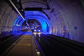 Second tube dedicated to sustainable mode of transport.
 -
 West entrance, Saône side.
 -
 Safety access door to the car tube


See also
- List of tunnels by location
- La Croix-Rousse
References
- v
- t
- e
- Terreaux
- Pentes de la Croix-Rousse
- Croix-Paquet
- Saint-Vincent
- Presqu'île
and tunnels
- Boulevard de la Croix-Rousse
- Cour des Voraces
- Montée de la Grande Côte
- Montée des Carmélites
- Passage Thiaffait
- Rue Burdeau
- Rue de l'Arbre-Sec
- Rue de la Bourse
- Rue de la République
- Rue des Capucins
- Rue du Bât-d'Argent
- Rue du Sergent Blandan
- Rue Édouard-Herriot
- Rue Lanterne
- Rue Royale
- Rue Sainte-Catherine
- Tunnel de la Croix-Rousse
monuments
| Authority control databases: Geographic |
|
|---|


