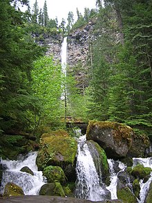
Watson Falls
Waterfall in North Umpqua River
| Watson Falls | |
|---|---|
 Watson Falls | |
 | |
| Location | North Umpqua River |
| Type | Plunge |
| Elevation | 3,214 ft (980 m) |
| Total height | 293 ft (89 m) |
Watson Falls is a 272-foot (83 m) waterfall on Watson Creek, a tributary of the Clearwater River, in Douglas County in the U.S. state of Oregon.[1] It is located at an elevation of 3,353 feet (1,022 m).[2]
See also
References
- ^ Bishop, Ellen Morris; Allen, John E. (2004). Hiking Oregon's geology. Seattle, Washington: Mountaineers Books. p. 159. ISBN 9780898868470. OCLC 53887464.
- ^ "Watson Falls". Geographic Names Information System. United States Geological Survey, United States Department of the Interior. November 28, 1980. Retrieved February 7, 2013.
External links
 Media related to Watson Falls at Wikimedia Commons
- Panoramic images of the falls from Don Bain's 360° Panoramas
- v
- t
- e
Waterfalls of Oregon
| (west to east) |
|
|---|---|
| Eagle Creek (north to south) |
| Northwest Oregon | |
|---|---|
| Willamette Valley | |
| Southern Cascades |
|
| Central Oregon |
| Authority control databases: Geographic |
|
|---|
43°14′29″N 122°23′24″W / 43.241511°N 122.390040°W / 43.241511; -122.390040
 | This Douglas County, Oregon state location article is a stub. You can help Wikipedia by expanding it. |
- v
- t
- e


