Mons Ampère
| Mons Ampère | ||
|---|---|---|
 Mons Ampère. Foto: LRO. | ||
| Coordenadas | 19°19′N 3°43′O / 19.32, -3.71 | |
| Localización administrativa | ||
| Localización | La Luna | |
| Características generales | ||
| Tipo | Montaña lunar | |
| Altitud | 1300 m (sobre el Mare Imbrium) | |
| Localización sobre el mapa lunar 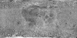  (Clementine Lunar Map 2.0) | ||
[editar datos en Wikidata] | ||
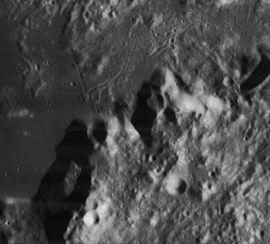
Mons Ampère (Monte Ampère en latín) es una montaña lunar ubicada aproximadamente en las coordenadas 19°N 4°O, en el centro de los Montes Apeninos.[1] La longitud del tramo montañoso es de unos 30 km.
El cráter más próximo es Huxley, situado unos 40 km al nor-noroeste. La elevación aproximada del monte sobre el nivel del Mare Imbrium es de unos 1300 m.[2]
 |
Referencias
- (WGPSN), IAU Working Group for Planetary System Nomenclature (13 de febrero de 2013). «Gazetteer of Planetary Nomenclature. 1:1 Million-Scale Maps of the Moon» (en inglés). UAI / USGS. Consultado el 6 de abril de 2016.
- Andersson, L. E.; Whitaker, E. A., (1982). NASA Catalogue of Lunar Nomenclature (en inglés). NASA RP-1097.
- Blue, Jennifer (25 de julio de 2007). «Gazetteer of Planetary Nomenclature» (en inglés). USGS. Consultado el 2 de enero de 2012.
- Bussey, B.; Spudis, P. (2004). The Clementine Atlas of the Moon (en inglés). Nueva York: Cambridge University Press. ISBN 0-521-81528-2.
- Cocks, Elijah E.; Cocks, Josiah C. (1995). Who's Who on the Moon: A Biographical Dictionary of Lunar Nomenclature (en inglés). Tudor Publishers. ISBN 0-936389-27-3.
- McDowell, Jonathan (15 de julio de 2007). «Lunar Nomenclature» (en inglés). Jonathan's Space Report. Consultado el 2 de enero de 2012.
- Menzel, D. H.; Minnaert, M.; Levin, B.; Dollfus, A.; Bell, B. (1971). «Report on Lunar Nomenclature by The Working Group of Commission 17 of the IAU». Space Science Reviews (en inglés) 12: 136.
- Moore, Patrick (2001). On the Moon (en inglés). Sterling Publishing Co. ISBN 0-304-35469-4.
- Price, Fred W. (1988). The Moon Observer's Handbook (en inglés). Cambridge University Press. ISBN 0521335000.
- Rükl, Antonín (1990). Atlas of the Moon (en inglés). Kalmbach Books. ISBN 0-913135-17-8.
- Webb, Rev. T. W. (1962). Celestial Objects for Common Telescopes, 6ª edición revisada (en inglés). Dover. ISBN 0-486-20917-2.
- Whitaker, Ewen A. (2003). Mapping and Naming the Moon (en inglés). Cambridge University Press. 978-0-521-54414-6.
- Wlasuk, Peter T. (2000). Observing the Moon (en inglés). Springer. ISBN 1-85233-193-3.
- «Lunar Impact Crater Database» (en inglés). Lunar and Planetary Institute (USRA). Consultado el 12 de septiembre de 2017.
Véase también
- Anexo:Montañas lunares
Enlaces externos
 Wikimedia Commons alberga una categoría multimedia sobre Mons Ampère.
- LPI. Digital Lunar Orbiter Photographic Atlas of the Moon.
- Mapa LROC
- Referencia USGS Mons Ampère
| Control de autoridades |
|
|---|
 Datos: Q627051
- Multimedia: Mons Ampère / Q627051


