Canet-en-Roussillon
| Kanet an Rusijon Canet-en-Roussillon | |
|---|---|
|
| |
| Osnovni podaci | |
| Država |  Francuska Francuska |
| Region | Langdok-Rusijon |
| Departman | Pyrénées-Orientales |
| Okrug | Perpinjan |
| Kanton | Kanet an Rusijon |
| Stanovništvo | |
| Stanovništvo (2011-01-01) | 13.091[1] |
| Gustina stanovništva | 433,19 st./km² |
| Geografija | |
| Koordinate | 42°42′24″N 3°00′28″E / 42.7066666666667°N 3.00777777777778°E / 42.7066666666667; 3.00777777777778 |
| Vremenska zona | UTC+1, ljeti UTC+2 |
| Nadmorska visina | 6 m |
| Površina | 30,22 km² |
  Kanet an Rusijon Kanet an Rusijon (Francuske) | |
| Ostali podaci | |
| Poštanski kod | 66140 |
| INSEE kod | 66037 |
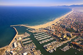
Kanet an Rusijon (fr. Canet-en-Roussillon) je naselje i opština u južnoj Francuskoj u regionu Langdok-Rusijon, u departmanu Istočni Pirineji koja pripada prefekturi Perpinjan.
Po podacima iz 2007. godine u opštini je živelo 12 164 stanovnika, a gustina naseljenosti je iznosila 403 stanovnika/km². Opština se prostire na površini od 30,22 km². Nalazi se na srednjoj nadmorskoj visini od 6 metara (maksimalnoj 37 m, a minimalnoj 0 m).
Demografija
| 1962. | 1968. | 1975. | 1982. | 1990. | 1999. | 2003. | 2007. | 2011. |
|---|---|---|---|---|---|---|---|---|
| 2.646 | 3.658 | 4.356 | 6.030 | 7.575 | 10.182 | 12.100 | 12.164 | 13.091 |
- Grafik promene broja stanovnika u toku poslednjih godina

Gradovi Partneri
- Maynooth, Irska od 2011[2]
Reference
Literatura
- Alexandra Hughes, Alex Hughes, Keith A Reader, Keith Reader, ur. (2001). Encyclopedia of Contemporary French Culture (Routledge; Routledge World Reference edition izd.). ISBN 0415263549.
- Robb, Graham (2008). The Discovery of France: A Historical Geography. W. W. Norton & Company. ISBN 0393333647.
- Ardagh, John (1991). France (Cultural Atlas of izd.). Facts on File. ISBN 081602619X.
- Jones, Colin (1999). The Cambridge Illustrated History of France (Cambridge Illustrated Histories izd.). Cambridge University Press. ISBN 0521669928.
- Sowerwine, Charles (2009). France since 1870: Culture, Society and the Making of the Republic (2nd izd.). Palgrave Macmillan. ISBN 0230573398.
- Roberts, William J. (2004). France: A Reference Guide from the Renaissance to the Present (European Nations) (European Nations izd.). Facts on File. ISBN 0816044732.
Vanjske veze
Canet-en-Roussillon na Wikimedijinoj ostavi
- Baza podataka: Insee (fr)
- http://leguy.be/environ.htm Arhivirano 2007-03-11 na Wayback Machine-u
- Canet-en-Roussillon na stranici Nacionalnog geografskog instituta Francuske (fr)
- Canet-en-Roussillon na stranici organizacije INSEE (fr)
- Najbliža naselja (kilometraža, pravac i koordinate)[mrtav link] (fr)
- Položaj mesta Canet-en-Roussillon na mapi Francuske (sa osnovnim podacima o mestu)[mrtav link] (fr)
- Plan naselja Canet-en-Roussillon na mapi (Mapquest)
- p
- r
- u
Albère • Alénya • Les Angles • Ansignan • Amélie-les-Bains-Palalda • Angoustrine-Villeneuve-des-Escaldes • Arboussols • Argelès-sur-Mer • Arles-sur-Tech • Ayguatébia-Talau • Bages • Baho • Baillestavy • Baixas • Banyuls-dels-Aspres • Banyuls-sur-Mer • Barcarès • Bastide • Bélesta • Bolquère • Bompas • Boule-d'Amont • Bouleternère • Boulou • Bourg-Madame • Brouilla • Casteil • Cassagnes • Cases-de-Pène • Caramany • Canohès • Canet-en-Roussillon • Canaveilles • Camélas • Campôme • Campoussy • Calmeilles • Calce • Cabestany • Cabanasse • Castelnou • Dorres • Espira-de-Conflent • Espira-de-l'Agly • Estavar • Estagel • Casefabre • Corsavy • Corneilla-la-Rivière • Corneilla-del-Vercol • Corneilla-de-Conflent • Céret • Corbère-les-Cabanes • Corbère • Caixas • Conat • Collioure • Cerbère • Codalet • Cluses • Coustouges • Clara • Caudiès-de-Fenouillèdes • Caudiès-de-Conflent • Claira • Catllar • Eyne • Eus • Estoher • Fourques • Fosse • Formiguères • Fontpédrouse • Fontrabiouse • Glorianes
| ||
|---|---|---|
| Metropolitanska Francuska | 01 Ain • 02 Aisne • 03 Allier • 04 Alpes-de-Haute-Provence • 05 Hautes-Alpes • 06 Alpes-Maritimes • 07 Ardèche • 08 Ardennes • 09 Ariège • 10 Aube • 11 Aude • 12 Aveyron • 13 Bouches-du-Rhône • 14 Calvados • 15 Cantal • 16 Charente • 17 Charente-Maritime • 18 Cher • 19 Corrèze • 2A Corse-du-Sud • 2B Haute-Corse • 21 Côte-d'Or • 22 Côtes-d'Armor • 23 Creuse • 24 Dordogne • 25 Doubs • 26 Drôme • 27 Eure • 28 Eure-et-Loir • 29 Finistère • 30 Gard • 31 Haute-Garonne • 32 Gers • 33 Gironde • 34 Hérault • 35 Ille-et-Vilaine • 36 Indre • 37 Indre-et-Loire • 38 Isère • 39 Jura • 40 Landes • 41 Loir-et-Cher • 42 Loire • 43 Haute-Loire • 44 Loire-Atlantique • 45 Loiret • 46 Lot • 47 Lot-et-Garonne • 48 Lozère • 49 Maine-et-Loire • 50 Manche • 51 Marne • 52 Haute-Marne • 53 Mayenne • 54 Meurthe-et-Moselle • 55 Meuse • 56 Morbihan • 57 Moselle • 58 Nièvre • 59 Nord • 60 Oise • 61 Orne • 62 Pas-de-Calais • 63 Puy-de-Dôme • 64 Pyrénées-Atlantiques • 65 Hautes-Pyrénées • 66 Pyrénées-Orientales • 67 Bas-Rhin • 68 Haut-Rhin • 69 Rhône - Métropole de Lyon • 70 Haute-Saône • 71 Saône-et-Loire • 72 Sarthe • 73 Savoie • 74 Haute-Savoie • 75 Paris • 76 Seine-Maritime • 77 Seine-et-Marne • 78 Yvelines • 79 Deux-Sèvres • 80 Somme • 81 Tarn • 82 Tarn-et-Garonne • 83 Var • 84 Vaucluse • 85 Vendée • 86 Vienne • 87 Haute-Vienne • 88 Vosges • 89 Yonne • 90 Territoire de Belfort • 91 Essonne • 92 Hauts-de-Seine • 93 Seine-Saint-Denis • 94 Val-de-Marne • 95 Val-d'Oise |  |
| Prekomorski departmani | 971 Guadeloupe • 972 Martinique • 973 Francuska Gvajana • 974 Réunion • 976 Mayotte | |
 | Ovaj članak o Francuskoj je u začetku. Možete pomoći Wikipediji tako što ćete ga proširiti. |
Koordinate: 42° 42' 24" SG Š, 03° 00' 28" IGD


