Amsterdam–Rhine Canal
You can help expand this article with text translated from the corresponding article in Dutch. (May 2024) Click [show] for important translation instructions.
- View a machine-translated version of the Dutch article.
- Machine translation, like DeepL or Google Translate, is a useful starting point for translations, but translators must revise errors as necessary and confirm that the translation is accurate, rather than simply copy-pasting machine-translated text into the English Wikipedia.
- Do not translate text that appears unreliable or low-quality. If possible, verify the text with references provided in the foreign-language article.
- You must provide copyright attribution in the edit summary accompanying your translation by providing an interlanguage link to the source of your translation. A model attribution edit summary is
Content in this edit is translated from the existing Dutch Wikipedia article at [[:nl:Amsterdam-Rijnkanaal]]; see its history for attribution. - You may also add the template
{{Translated|nl|Amsterdam-Rijnkanaal}}to the talk page. - For more guidance, see Wikipedia:Translation.
52°9′8″N 5°0′23″E / 52.15222°N 5.00639°E / 52.15222; 5.00639
| Amsterdam–Rhine Canal | |
|---|---|
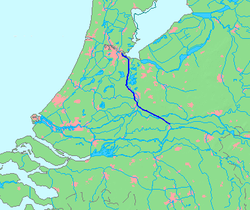 Map of the Amsterdam–Rhine Canal | |
| Specifications | |
| Length | 72 km (45 mi) |
| History | |
| Date completed | 1952 |
| Geography | |
| Start point | Amsterdam, Netherlands |
| End point | Waal river near Tiel, Netherlands |
 | |
The Amsterdam–Rhine Canal (Dutch: Amsterdam-Rijnkanaal) is a canal in the Netherlands that was built to connect the port and capital city of Amsterdam to the main shipping artery of the Rhine. Its course follows a generally southeasterly direction as it goes through the city of Utrecht towards Wijk bij Duurstede where it intersects the Lek branch of the Rhine and then continues on to the river Waal near Tiel, with a branch, the Lek Canal, to the Lek near Nieuwegein.[1][2] The Amsterdam-Rhine Canal is the world's most frequented artificial waterway with an annual average of 100,000 ships.[3][better source needed]
References
- v
- t
- e
Rijn
Rhin
- Current distributaries
- Waal
- Nederrijn
- IJssel
- Lek
- Merwede
- Boven Merwede
- Nieuwe Merwede
- Beneden Merwede
- Oude Maas
- Dordtsche Kil
- Noord
- Nieuwe Maas
- Scheur
- Nieuwe Waterweg
- Former distributaries
- Kromme Rijn
- Leidse Rijn
- Oude Rijn
- Hollandse IJssel
- Vecht
- Waaltje
- Brielse Maas
- Spui
- Current estuaries
- Nieuwe Waterweg
- IJsselmeer
- Former estuaries
- Hollands Diep
- Haringvliet
- Volkerak
- Krammer
- Grevelingen
- Keeten-Mastgat
- Oosterschelde
- Associated canals
- Bijlands Kanaal
- Pannerdens Kanaal
- Amsterdam–Rhine Canal
- Vaartse Rijn
- Nieuwe Merwede
- Nieuwe Waterweg
- Scheldt–Rhine Canal
- Maas–Waal Canal
Maas
- Current distributaries
- Bergse Maas
- Amer
- Former distributaries
- Oude Maasje
- Afgedamde Maas
- Merwede
- Boven Merwede
- Beneden Merwede
- Oude Maas
- Dordtsche Kil
- Noord
- Nieuwe Maas
- Scheur
- Nieuwe Waterweg
- Current estuaries
- Former estuaries
- Hollands Diep
- Haringvliet
- Volkerak
- Krammer
- Grevelingen
- Keeten-Mastgat
- Oosterschelde
- Associated canals
- Heusden Canal
- Bergse Maas
- Maas–Waal Canal
Schelde
Escaut
- Current distributaries
- Western Scheldt
- Former distributaries
- Oosterschelde
- Eendracht
- Current estuaries
- Western Scheldt
- Former estuaries
- Oosterschelde
- Krammer
- Grevelingen
- Associated canals
- Scheldt–Rhine Canal
- Canal through Zuid-Beveland
- Canal through Walcheren
(directly draining
into the delta)
- Linge
- Mark
- Donge
- Rotte
- Oude IJssel
Peninsulas
- Rozenburg
- IJsselmonde
- Het Eiland van Dordt
- Voorne and Putten
- Hoeksche Waard
- Tiengemeten
- Goeree-Overflakkee
- Schouwen-Duiveland
- Tholen
- Sint Philipsland
- Walcheren
- Noord-Beveland
- Zuid-Beveland
- Delta Works
- Verdronken Land van Reimerswaal
- Verdronken Land van Saeftinghe
- St. Elizabeth's flood (1421)
- St. Felix's Flood
- All Saints' Flood (1570)
 | This article about transport in the Netherlands is a stub. You can help Wikipedia by expanding it. |
- v
- t
- e


