Volkerak
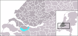
The Volkerak is a body of water in the Netherlands. It is part of the Rhine–Meuse–Scheldt delta, and is situated between the island Goeree-Overflakkee to the north-west and the Dutch mainland to the south and east. The western part of the Volkerak is also called Krammer. Tributaries of the Volkerak are the Dintel and Steenbergse Vliet.
Before 1987, it was a tidal river open to the North Sea, but it was closed off as part of the Delta Works; it is now a fresh water lake.
Delta Works
The Volkerak is navigable by sea-going ships. On the eastern end are the Volkerak Locks (Volkeraksluizen) connecting it to the Hollands Diep. At the western end is the Philipsdam and Krammer Locks (Krammersluizen)[1] connecting it to the Eastern Scheldt (Oosterschelde), and also the Grevelingendam and Grevelingen Lock (Grevelingensluis)[2] connecting it to the Grevelingen Grevelingen. Finally, the Scheldt–Rhine Canal connects it to the port of Antwerp and thus the North Sea, providing access for ocean-going vessels.
Future
Due to the low supply of fresh water to the now-enclosed Volkerak, and runoff of agricultural nutrients, the lake suffers from algal bloom throughout the summer,[3] and swimming is prohibited. The decision to transform it again into a salt water lake could be taken between 2015 and 2020.
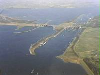
Volkerak Locks
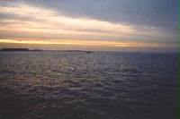
View of Volkerak
References
- ^ "The Krammer Locks (Krammersluizen)". Deltawerken Online. Stichting Deltawerken Online. Retrieved 14 November 2021.
- ^ "Grevelingen dam". Deltawerken Online. Stichting Deltawerken Online. Retrieved 14 November 2021.
- ^ Verspagen JM, Passarge J, Jöhnk KD, Visser PM, Peperzak L, Boers P, Laanbroek HJ, Huisman J (2006). "Water management strategies against toxic Microcystis blooms in the Dutch delta" (PDF). Ecological Applications. 16 (1): 313–27. doi:10.1890/04-1953. PMID 16705982.
External links
- Information by Rijkswaterstaat
- v
- t
- e
Rijn
Rhin
- Current distributaries
- Waal
- Nederrijn
- IJssel
- Lek
- Merwede
- Boven Merwede
- Nieuwe Merwede
- Beneden Merwede
- Oude Maas
- Dordtsche Kil
- Noord
- Nieuwe Maas
- Scheur
- Nieuwe Waterweg
- Former distributaries
- Kromme Rijn
- Leidse Rijn
- Oude Rijn
- Hollandse IJssel
- Vecht
- Waaltje
- Brielse Maas
- Spui
- Current estuaries
- Nieuwe Waterweg
- IJsselmeer
- Former estuaries
- Hollands Diep
- Haringvliet
- Volkerak
- Krammer
- Grevelingen
- Keeten-Mastgat
- Oosterschelde
Maas
- Current distributaries
- Bergse Maas
- Amer
- Former distributaries
- Oude Maasje
- Afgedamde Maas
- Merwede
- Boven Merwede
- Beneden Merwede
- Oude Maas
- Dordtsche Kil
- Noord
- Nieuwe Maas
- Scheur
- Nieuwe Waterweg
- Current estuaries
- Former estuaries
- Hollands Diep
- Haringvliet
- Volkerak
- Krammer
- Grevelingen
- Keeten-Mastgat
- Oosterschelde
- Associated canals
- Heusden Canal
- Bergse Maas
- Maas–Waal Canal
Schelde
Escaut
- Current distributaries
- Western Scheldt
- Former distributaries
- Oosterschelde
- Eendracht
- Current estuaries
- Western Scheldt
- Former estuaries
- Oosterschelde
- Krammer
- Grevelingen
- Associated canals
- Scheldt–Rhine Canal
- Canal through Zuid-Beveland
- Canal through Walcheren
(directly draining
into the delta)
- Linge
- Mark
- Donge
- Rotte
- Oude IJssel
Peninsulas
- Rozenburg
- IJsselmonde
- Het Eiland van Dordt
- Voorne and Putten
- Hoeksche Waard
- Tiengemeten
- Goeree-Overflakkee
- Schouwen-Duiveland
- Tholen
- Sint Philipsland
- Walcheren
- Noord-Beveland
- Zuid-Beveland
- Delta Works
- Verdronken Land van Reimerswaal
- Verdronken Land van Saeftinghe
- St. Elizabeth's flood (1421)
- St. Felix's Flood
- All Saints' Flood (1570)
51°39′N 4°18′E / 51.65°N 4.3°E / 51.65; 4.3


