Ernesto Córdoba Campos
Corregimiento in Panamá, Panama
Ernesto Córdoba Campos | |
|---|---|
Corregimiento | |
| Country |  Panama Panama |
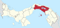
| Province | Panamá |
| District | Panamá |
| Established | July 10, 2009[1] |
| Area [1] | |
| • Land | 30.5 km2 (11.8 sq mi) |
| Population (2010)[1] | |
| • Total | 55,784 |
| • Density | 1,826/km2 (4,730/sq mi) |
| Population density calculated based on land area. | |
| Time zone | UTC−5 (EST) |
Ernesto Córdoba Campos is a corregimiento in Panamá District, Panamá Province, Panama with a population of 55,784 as of 2010.[1] It was created by Law 42 of July 10, 2009.[1]
References
- ^ a b c d e "Cuadro 11 (Superficie, población y densidad de población en la República...)" [Table 11 (Area, population, and population density in the Republic...)] {{webarchive |url=https://web.archive.org/web/20160304030354/http://www.contraloria.gob.pa/inec/archivos/P3601Cuadro11.xls |date=March 4, 2016 }} (.xls). In "Resultados Finales Básicos" [Basic Final Results] (in Spanish). National Institute of Statistics and Census of Panama. Archived from the original on July 10, 2015. Retrieved May 26, 2015.
- v
- t
- e
Capital: Panama
- San Miguel
- La Ensenada
- La Esmeralda
- La Guinea
- Pedro González
- Saboga
- Chepo
- Cañita
- Chepillo
- El Llano
- Las Margaritas
- Santa Cruz de Chinina
- Madungandí
- Tortí
- Chimán
- Brujas
- Gonzalo Vásquez
- Pásiga
- Unión Santeña
- 24 de Diciembre
- Alcalde Díaz
- Ancón
- Bella Vista
- Betania
- Caimitillo
- Calidonia
- Chilibre
- El Chorrillo
- Curundú
- Ernesto Córdoba Campos
- Juan Díaz
- Las Cumbres
- Las Mañanitas
- Pacora
- Parque Lefevre
- Pedregal
- Pueblo Nuevo
- Río Abajo
- San Felipe
- San Francisco
- San Martín
- Santa Ana
- Tocumen
This article about the geography of Panamá Province is a stub. You can help Wikipedia by expanding it. |
- v
- t
- e


 Ernesto_Córdoba_Campos