List of listed buildings in Dryfesdale, Dumfries and Galloway
This is a list of listed buildings in the parish of Dryfesdale in Dumfries and Galloway, Scotland.
Map all coordinates using OpenStreetMap
Download coordinates as:
- KML
- GPX (all coordinates)
- GPX (primary coordinates)
- GPX (secondary coordinates)
List
| Name | Location | Date Listed | Grid Ref. [note 1] | Geo-coordinates | Notes | LB Number [note 2] | Image |
|---|---|---|---|---|---|---|---|
| Dryfeholm West Lodge, including Workshops and Store | 55°08′14″N 3°23′35″W / 55.137317°N 3.39314°W / 55.137317; -3.39314 (Dryfeholm West Lodge, including Workshops and Store) | Category B | 3442 |  Upload Photo | |||
| Hillside Cottage and former Dovecot (at Hillside House) | 55°09′22″N 3°21′13″W / 55.156195°N 3.353541°W / 55.156195; -3.353541 (Hillside Cottage and former Dovecot (at Hillside House)) | Category B | 3445 | Upload Photo | |||
| Johnstone Burial Ground | 55°08′28″N 3°22′05″W / 55.141196°N 3.368016°W / 55.141196; -3.368016 (Johnstone Burial Ground) | Category B | 3446 | Upload Photo | |||
| Lockerbie House Hotel | 55°08′19″N 3°21′00″W / 55.138486°N 3.349976°W / 55.138486; -3.349976 (Lockerbie House Hotel) | Category B | 3447 |  Upload another image | |||
| Scroggs Mill and Mill Cottage | 55°07′06″N 3°18′50″W / 55.11821°N 3.313966°W / 55.11821; -3.313966 (Scroggs Mill and Mill Cottage) | Category C(S) | 3451 | Upload Photo | |||
| Shillahill Bridge | 55°06′45″N 3°24′10″W / 55.112636°N 3.402738°W / 55.112636; -3.402738 (Shillahill Bridge) | Category A | 3453 |  Upload another image | |||
| Hallmuir, Ukrainian Chapel (Greek Catholic) with Memorial | 55°05′58″N 3°22′01″W / 55.099508°N 3.367077°W / 55.099508; -3.367077 (Hallmuir, Ukrainian Chapel (Greek Catholic) with Memorial) | Category B | 49592 | 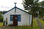 Upload another image | |||
| Bengall Farm, former Smithy | 55°05′25″N 3°23′38″W / 55.090199°N 3.393851°W / 55.090199; -3.393851 (Bengall Farm, former Smithy) | Category C(S) | 3439 | Upload Photo | |||
| Roberthill Farmhouse and adjoining Steading Blocks | 55°06′09″N 3°23′28″W / 55.102372°N 3.391077°W / 55.102372; -3.391077 (Roberthill Farmhouse and adjoining Steading Blocks) | Category B | 3449 | Upload Photo | |||
| Halldykes Farmhouse | 55°07′49″N 3°19′26″W / 55.130377°N 3.324011°W / 55.130377; -3.324011 (Halldykes Farmhouse) | Category B | 3443 | Upload Photo | |||
| Halldykes Farm Steading, East Range (Byre and Barn) | 55°07′47″N 3°19′25″W / 55.129689°N 3.323659°W / 55.129689; -3.323659 (Halldykes Farm Steading, East Range (Byre and Barn)) | Category B | 3444 | Upload Photo | |||
| St Michael's House | 55°08′51″N 3°21′14″W / 55.147538°N 3.353766°W / 55.147538; -3.353766 (St Michael's House) | Category B | 3450 | Upload Photo | |||
| Cudscroft | 55°07′57″N 3°21′00″W / 55.132572°N 3.350012°W / 55.132572; -3.350012 (Cudscroft) | Category C(S) | 3440 | Upload Photo | |||
| Dryfeholm Farm, Long Haybarn (at North End Of Steading) | 55°08′23″N 3°23′40″W / 55.139691°N 3.394509°W / 55.139691; -3.394509 (Dryfeholm Farm, Long Haybarn (at North End Of Steading)) | Category B | 3441 | Upload Photo | |||
| Muirhead Farmhouse | 55°07′26″N 3°22′01″W / 55.123836°N 3.366967°W / 55.123836; -3.366967 (Muirhead Farmhouse) | Category B | 3448 | Upload Photo |
Key
The scheme for classifying buildings in Scotland is:
- Category A: "buildings of national or international importance, either architectural or historic; or fine, little-altered examples of some particular period, style or building type."[1]
- Category B: "buildings of regional or more than local importance; or major examples of some particular period, style or building type, which may have been altered."[1]
- Category C: "buildings of local importance; lesser examples of any period, style, or building type, as originally constructed or moderately altered; and simple traditional buildings which group well with other listed buildings."[1]
In March 2016 there were 47,288 listed buildings in Scotland. Of these, 8% were Category A, and 50% were Category B, with the remaining 42% being Category C.[2]
Notes
- ^ Sometimes known as OSGB36, the grid reference (where provided) is based on the British national grid reference system used by the Ordnance Survey.
• "Guide to National Grid". Ordnance Survey. Retrieved 12 December 2007.
• "Get-a-map". Ordnance Survey. Retrieved 17 December 2007. - ^ Historic Environment Scotland assign a unique alphanumeric identifier to each designated site in Scotland, for listed buildings this always begins with "LB", for example "LB12345".
References
- All entries, addresses and coordinates are based on data from Historic Scotland. This data falls under the Open Government Licence
- ^ a b c "What is Listing?". Historic Environment Scotland. Retrieved 29 May 2018.
- ^ Scotland's Historic Environment Audit 2016 (PDF). Historic Environment Scotland and the Built Environment Forum Scotland. pp. 15–16. Retrieved 29 May 2018.
- v
- t
- e
- Annan
- Applegarth
- Caerlaverock
- Canonbie
- Closeburn
- Cummertrees
- Dalton
- Dornock
- Dryfesdale
- Dumfries
- Dunscore
- Durisdeer
- Eskdalemuir
- Ewes
- Glencairn
- Gretna
- Half Morton
- Hoddom
- Holywood
- Hutton and Corrie
- Johnstone
- Keir
- Kirkconnel
- Kirkmahoe
- Kirkmichael
- Kirkpatrick-Fleming
- Kirkpatrick-Juxta
- Langholm
- Lochmaben
- Lockerbie
- Middlebie
- Moffat
- Morton
- Mouswald
- Penpont
- Ruthwell
- Sanquhar
- St Mungo
- Tinwald
- Torthorwald
- Tundergarth
- Tynron
- Wamphray
- Westerkirk
- Anwoth
- Balmaclellan
- Balmaghie
- Borgue
- Buittle
- Carsphairn
- Castle Douglas
- Colvend and Southwick
- Crossmichael
- Dalbeattie
- Dalry
- Gatehouse of Fleet
- Girthon
- Kells
- Kelton
- Kirkbean
- Kirkcudbright
- Kirkgunzeon
- Kirkmabreck
- Kirkpatrick Durham
- Kirkpatrick Irongray
- Lochrutton
- Minnigaff
- New Abbey
- New Galloway
- Newton Stewart
- Parton
- Rerrick
- Terregles
- Tongland
- Troqueer
- Twynholm
- Urr


