National Register of Historic Places listings in Rocky Mountain National Park
This is a complete list of the properties and districts on the National Register of Historic Places in Rocky Mountain National Park, Colorado, United States. The locations of National Register properties and districts for which the latitude and longitude coordinates are included below, may be seen in a map.[1]
There are 49 properties and districts listed on the National Register in the park, one of which is a National Historic Landmark.
This National Park Service list is complete through NPS recent listings posted August 30, 2024.[2]
Map all coordinates using OpenStreetMap
Download coordinates as:
- KML
- GPX (all coordinates)
- GPX (primary coordinates)
- GPX (secondary coordinates)
Current listings
| [3] | Name on the Register | Image | Date listed[4] | Location | City or town | Description |
|---|---|---|---|---|---|---|
| 1 | Bear Lake Comfort Station |  | January 29, 1988 (#87001137) | Bear Lake 40°18′44″N 105°38′42″W / 40.312222°N 105.645°W / 40.312222; -105.645 (Bear Lake Comfort Station) | Estes Park | |
| 2 | Cascade Cottages |  | August 27, 2020 (#100005475) | Fall River Road 40°24′05″N 105°36′10″W / 40.401417°N 105.602737°W / 40.401417; -105.602737 (Cascade Cottages) | Estes Park | |
| 3 | Dutchtown | Upload image | January 29, 1988 (#76002292) | Ditch Rd. 40°26′16″N 105°52′55″W / 40.437778°N 105.881944°W / 40.437778; -105.881944 (Dutchtown) | Grand Lake | |
| 4 | East Inlet Trail |  | February 28, 2005 (#05000073) | Rocky Mountain National Park 39°54′37″N 105°44′30″W / 39.910278°N 105.741667°W / 39.910278; -105.741667 (East Inlet Trail) | Estes Park | |
| 5 | East Longs Peak Trail |  | July 10, 2007 (#07000740) | West of State Highway 7 40°16′20″N 105°36′2″W / 40.27222°N 105.60056°W / 40.27222; -105.60056 (East Longs Peak Trail-Longs Peak Trail-Keyhole Route-Shelf Trail)[5] 40°16′20″N 105°36′02″W / 40.272222°N 105.600556°W / 40.272222; -105.600556 (East Longs Peak Trail) | Allenspark | |
| 6 | Fall River Entrance Historic District |  | January 29, 1988 (#87001139) | Fall River Entrance 40°24′11″N 105°35′13″W / 40.40312°N 105.58707°W / 40.40312; -105.58707 (Fall River Entrance Historic District) | Estes Park | |
| 7 | Fall River Pass Ranger Station |  | January 29, 1988 (#87001140) | Fall River Pass 40°26′27″N 105°45′13″W / 40.440833°N 105.753611°W / 40.440833; -105.753611 (Fall River Pass Ranger Station) | Estes Park | |
| 8 | Fall River Pump House and Catchment Basin |  | August 30, 2006 (#06000735) | Near the top of Fall River Road in Rocky Mountain National Park 40°26′15″N 105°44′50″W / 40.4375°N 105.747222°W / 40.4375; -105.747222 (Fall River Pump House and Catchment Basin) | Estes Park | |
| 9 | Fall River Road |  | July 20, 1987 (#87001129) | Fall River Rd. 40°25′47″N 105°42′43″W / 40.429722°N 105.711944°W / 40.429722; -105.711944 (Fall River Road) | Estes Park | |
| 10 | Fern Lake Patrol Cabin |  | January 29, 1988 (#87001142) | Fern Lake 40°20′17″N 105°40′34″W / 40.338056°N 105.676111°W / 40.338056; -105.676111 (Fern Lake Patrol Cabin) | Estes Park | |
| 11 | Fern Lake Trail |  | February 28, 2005 (#05000074) | Rocky Mountain National Park 40°20′34″N 105°39′48″W / 40.342778°N 105.663333°W / 40.342778; -105.663333 (Fern Lake Trail) | Estes Park | |
| 12 | Flattop Mountain Trail |  | September 27, 2007 (#07000999) | Rocky Mountain National Park 40°18′50″N 105°40′42″W / 40.31389°N 105.67833°W / 40.31389; -105.67833 (Flattop Mountain Trail)[6] 40°18′50″N 105°40′42″W / 40.313889°N 105.678333°W / 40.313889; -105.678333 (Flattop Mountain Trail) | Estes Park | |
| 13 | Gem Lake Trail |  | January 29, 2008 (#07001473) | North of Devils Gulch Rd. to Gem Lake 40°24′40″N 105°30′13″W / 40.41111°N 105.50361°W / 40.41111; -105.50361 (Gem Lake Trail)[7] 40°24′40″N 105°30′13″W / 40.411111°N 105.503611°W / 40.411111; -105.503611 (Gem Lake Trail) | Estes Park | |
| 14 | Glacier Basin Campground Ranger Station |  | July 20, 1987 (#87001143) | Glacier Basin 40°19′48″N 105°35′40″W / 40.33°N 105.594444°W / 40.33; -105.594444 (Glacier Basin Campground Ranger Station) | Estes Park | |
| 15 | Grand River Ditch | 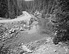 | September 29, 1976 (#76000218) | North of Grand Lake 40°25′10″N 105°52′12″W / 40.419444°N 105.87°W / 40.419444; -105.87 (Grand River Ditch) | Grand Lake | |
| 16 | Holzwarth Historic District |  | December 2, 1977 (#77000112) | North of Grand Lake on Trail Ridge Road 40°22′13″N 105°51′28″W / 40.370278°N 105.857778°W / 40.370278; -105.857778 (Holzwarth Historic District) | Grand Lake | |
| 17 | Lake Haiyaha Trail |  | March 5, 2008 (#08000125) | Roughly along Bear, Nymph, and Dream Lakes, then up Chaos Canyon 40°18′17″N 105°39′44″W / 40.30472°N 105.66222°W / 40.30472; -105.66222 (Flattop Mountain Trail)[8] 40°18′17″N 105°39′44″W / 40.304722°N 105.662222°W / 40.304722; -105.662222 (Lake Haiyaha Trail) | Estes Park | |
| 18 | Little Buckaroo Ranch Barn |  | July 8, 2009 (#09000490) | 20631 Trail Ridge Road 40°21′22″N 105°51′23″W / 40.3562°N 105.8564°W / 40.3562; -105.8564 (Little Buckaroo Ranch Barn) | Grand Lake | |
| 19 | Lost Lake Trail | Upload image | March 5, 2008 (#08000126) | Roughly along the North Fork of the Big Thompson River 40°29′56″N 105°33′2″W / 40.49889°N 105.55056°W / 40.49889; -105.55056 (East Longs Peak Trail-Longs Peak Trail-Keyhole Route-Shelf Trail)[9] 40°29′56″N 105°33′02″W / 40.498889°N 105.550556°W / 40.498889; -105.550556 (Lost Lake Trail) | Estes Park | |
| 20 | Lulu City Site |  | September 14, 1977 (#77001562) | North of Grand Lake on Trail Ridge Rd. 40°26′30″N 105°50′50″W / 40.441667°N 105.847222°W / 40.441667; -105.847222 (Lulu City Site) | Grand Lake | |
| 21 | McGraw Ranch |  | September 17, 1998 (#98001163) | McGraw Ranch Rd. 40°25′53″N 105°30′06″W / 40.431389°N 105.501667°W / 40.431389; -105.501667 (McGraw Ranch) | Estes Park | |
| 22 | Milner Pass Road Camp Mess Hall and House |  | July 20, 1987 (#87001130) | Milner Pass Rd. 40°25′02″N 105°48′57″W / 40.417222°N 105.815833°W / 40.417222; -105.815833 (Milner Pass Road Camp Mess Hall and House) | Estes Park | |
| 23 | Moraine Lodge |  | October 8, 1976 (#76000206) | West of Estes Park off U.S. Route 36 on Bear Lake Rd. 40°21′31″N 105°34′59″W / 40.358611°N 105.583056°W / 40.358611; -105.583056 (Moraine Lodge) | Estes Park | |
| 24 | Moraine Park Museum and Amphitheater | 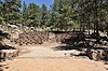 | June 15, 2005 (76000206 #Lodge 76000206) | Rocky Mountain National Park 40°21′31″N 105°35′02″W / 40.3586°N 105.5839°W / 40.3586; -105.5839 (Moraine Park Museum and Amphitheater) | Estes Park | |
| 25 | North Inlet Trail |  | March 5, 2008 (#08000127) | Roughly along North Inlet and Hallett Creek to Flattop Mountain 40°15′50″N 105°47′22″W / 40.26389°N 105.78944°W / 40.26389; -105.78944 (North Inlet Trail)[10] 40°15′50″N 105°47′22″W / 40.263889°N 105.789444°W / 40.263889; -105.789444 (North Inlet Trail) | Estes Park and Grand Lake | |
| 26 | Rocky Mountain National Park Administration Building |  | January 3, 2001 (#01000069) | U.S. Route 36 40°21′58″N 105°33′38″W / 40.366111°N 105.560556°W / 40.366111; -105.560556 (Rocky Mountain National Park Administration Building) | Estes Park | |
| 27 | Rocky Mountain National Park Utility Area Historic District | 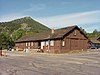 | March 18, 1982 (#82001717) | Beaver Meadows Entrance Rd. 40°21′50″N 105°33′38″W / 40.363889°N 105.560556°W / 40.363889; -105.560556 (Rocky Mountain National Park Utility Area Historic District) | Estes Park | |
| 28 | Sandbeach Lake Trail | Upload image | January 29, 2008 (#07001471) | South of Lookout Mountain 40°13′14″N 105°32′12″W / 40.220556°N 105.536667°W / 40.220556; -105.536667 (Sandbeach Lake Trail) | Meeker Park | |
| 29 | Shadow Mountain Lookout |  | August 2, 1978 (#78000279) | Southeast of Grand Lake in Rocky Mountain National Park 40°13′50″N 105°48′52″W / 40.230556°N 105.814444°W / 40.230556; -105.814444 (Shadow Mountain Lookout) | Grand Lake | |
| 30 | Shadow Mountain Trail |  | March 5, 2008 (#08000124) | Eastern side of Shadow Mountain Lake 40°13′40″N 105°49′8″W / 40.22778°N 105.81889°W / 40.22778; -105.81889 (Shadow Mountain Trail)[11] 40°13′40″N 105°49′08″W / 40.2278°N 105.8189°W / 40.2278; -105.8189 (Shadow Mountain Trail) | Grand Lake | |
| 31 | Snogo Snow Plow |  | October 4, 2006 (#06000934) | Rocky Mountain National Park 40°21′51″N 105°33′34″W / 40.364167°N 105.559444°W / 40.364167; -105.559444 (Snogo Snow Plow) | Estes Park | |
| 32 | Thunder Lake Patrol Cabin |  | January 29, 1988 (#87001124) | Thunder Lake 40°13′20″N 105°38′39″W / 40.222222°N 105.644167°W / 40.222222; -105.644167 (Thunder Lake Patrol Cabin) | Estes Park | |
| 33 | Thunder Lake Trail-Bluebird Lake Trail | Upload image | January 29, 2008 (#07001472) | Roughly along the North St. Vrain Creek, west of Wild Basin Ranger Station 40°11′34″N 105°39′07″W / 40.192778°N 105.651944°W / 40.192778; -105.651944 (Thunder Lake Trail-Bluebird Lake Trail) | Allenspark | |
| 34 | Timber Creek Campground Comfort Station No. 245 |  | January 29, 1988 (#87001131) | Timber Creek Campground 40°22′50″N 105°51′05″W / 40.380556°N 105.851389°W / 40.380556; -105.851389 (Timber Creek Campground Comfort Station No. 245) | Estes Park | |
| 35 | Timber Creek Campground Comfort Station No. 246 |  | January 29, 1988 (#87001132) | Timber Creek Campground 40°22′49″N 105°51′00″W / 40.380278°N 105.85°W / 40.380278; -105.85 (Timber Creek Campground Comfort Station No. 246) | Estes Park | |
| 36 | Timber Creek Campground Comfort Station No. 247 | 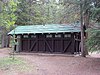 | January 29, 1988 (#87001131) | Timber Creek Campground 40°22′42″N 105°51′05″W / 40.378333°N 105.851389°W / 40.378333; -105.851389 (Timber Creek Campground Comfort Station No. 247) | Estes Park | |
| 37 | Timber Creek Road Camp Barn | 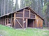 | July 30, 1987 (#87001134) | Approximately 200 yards south of Columbine Lake Rd., 450 yards west of the Kawuneeche Visitor Center 40°22′45″N 105°50′53″W / 40.379167°N 105.848056°W / 40.379167; -105.848056 (Timber Creek Road Camp Barn) | Estes Park | |
| 38 | Timberline Cabin | 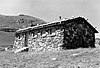 | January 29, 1988 (#87001136) | Fall River Rd. 40°26′30″N 105°44′37″W / 40.441667°N 105.743611°W / 40.441667; -105.743611 (Timberline Cabin) | Estes Park | Demolished.[12] |
| 39 | Tonahutu Creek Trail |  | March 5, 2008 (#08000130) | Roughly along Tonahutu Creek to Flattop Mountain 40°19′10″N 105°46′32″W / 40.31944°N 105.77556°W / 40.31944; -105.77556 (Tonahutu Creek Trail)[13] 40°19′10″N 105°46′32″W / 40.319444°N 105.775556°W / 40.319444; -105.775556 (Tonahutu Creek Trail) | Estes Park and Grand Lake | |
| 40 | Trail Ridge Road | 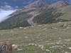 | November 14, 1984 (#84000242) | Rocky Mountain National Park 40°21′30″N 105°45′47″W / 40.358333°N 105.763056°W / 40.358333; -105.763056 (Trail Ridge Road) | Estes Park and Grand Lake | |
| 41 | Twin Sisters Lookout |  | December 24, 1992 (#92001670) | On the Twin Sisters Peaks in Rocky Mountain National Park 40°17′21″N 105°31′03″W / 40.289167°N 105.5175°W / 40.289167; -105.5175 (Twin Sisters Lookout) | Estes Park | |
| 42 | Agnes Vaille Shelter | 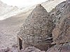 | December 24, 1992 (#92001669) | Northwest of Longs Peak along the East Longs Peak Trail in Rocky Mountain National Park 40°15′38″N 105°37′13″W / 40.260556°N 105.620278°W / 40.260556; -105.620278 (Agnes Vaille Shelter) | Estes Park | |
| 43 | William Allen White Cabins |  | October 25, 1973 (#73001944) | West of Estes Park of Moraine Park Visitor Center in Rocky Mountain National Park 40°21′22″N 105°34′55″W / 40.356111°N 105.581944°W / 40.356111; -105.581944 (William Allen White Cabins) | Estes Park | |
| 44 | Wild Basin House |  | January 29, 1988 (#87001125) | Wild Basin 40°12′29″N 105°33′56″W / 40.208056°N 105.565556°W / 40.208056; -105.565556 (Wild Basin House) | Estes Park | |
| 45 | Wild Basin Ranger Station and House |  | January 29, 1988 (#87001126) | Wild Basin 40°12′32″N 105°33′55″W / 40.208889°N 105.565278°W / 40.208889; -105.565278 (Wild Basin Ranger Station and House) | Estes Park | |
| 46 | Beatrice Willard Alpine Tundra Research Plots |  | October 25, 2007 (#07001101) | U.S. Route 34 at Rock Cut and Forest Canyon 40°23′43″N 105°42′40″W / 40.3953°N 105.7111°W / 40.3953; -105.7111 (Beatrice Willard Alpine Tundra Research Plots) | Estes Park | |
| 47 | Willow Park Patrol Cabin |  | July 20, 1987 (#87001144) | Fall River Rd. 40°25′59″N 105°44′01″W / 40.433056°N 105.733611°W / 40.433056; -105.733611 (Willow Park Patrol Cabin) | Estes Park | |
| 48 | Willow Park Stable |  | July 20, 1987 (#87001145) | Fall River Pass 40°26′01″N 105°43′59″W / 40.433611°N 105.733056°W / 40.433611; -105.733056 (Willow Park Stable) | Estes Park | |
| 49 | Ypsilon Lake Trail |  | March 5, 2008 (#08000131) | Along a ridge between Ciquita Creek and the Roaring River 40°25′43″N 105°39′02″W / 40.428702°N 105.650573°W / 40.428702; -105.650573 (Ypsilon Lake Trail) | Estes Park |
Former listings
| [3] | Name on the Register | Image | Date listed | Date removed | Location | City or town | Description |
|---|---|---|---|---|---|---|---|
| 1 | Bear Lake Ranger Station |  | January 29, 1988 (#87001138) | April 9, 2009 | Bear Lake 40°18′44″N 105°38′46″W / 40.3122°N 105.6461°W / 40.3122; -105.6461 (Bear Lake Ranger Station) | Estes Park |
See also
- Architects of the National Park Service
- National Register of Historic Places listings in Boulder County, Colorado
- National Register of Historic Places listings in Grand County, Colorado
- National Register of Historic Places listings in Larimer County, Colorado
- List of National Historic Landmarks in Colorado
- National Register of Historic Places listings in Colorado
References
- National Register of Historic Places Inventory - Nomination Form: Multiple Resource Nomination for Rocky Mountain National Park. National Park Service 1987 https://npgallery.nps.gov/NRHP/GetAsset/NRHP/64000077_text
- Standish, Sierra. National Register of Historic Places Multiple Property Documentation Form: Rocky Mountain National Park MPS (additional documentation - trails). National Park Service September 27, 2004 https://npgallery.nps.gov/NRHP/GetAsset/NRHP/64500913_text
- ^ The latitude and longitude information provided in this table was derived originally from the National Register Information System, which has been found to be fairly accurate for about 99% of listings. Some locations in this table may have been corrected to current GPS standards.
- ^ National Park Service, United States Department of the Interior, "National Register of Historic Places: Weekly List Actions", retrieved August 30, 2024.
- ^ a b Numbers represent an alphabetical ordering by significant words. Various colorings, defined here, differentiate National Historic Landmarks and historic districts from other NRHP buildings, structures, sites or objects.
- ^ The eight-digit number below each date is the number assigned to each location in the National Register Information System database, which can be viewed by clicking the number.
- ^ Coordinates are those of the East Longs Peak Trail as provided by its GNIS record; the NRIS gives no coordinates
- ^ Coordinates are derived from its GNIS record; the NRIS gives no coordinates
- ^ Coordinates are those of Gem Lake as provided by its GNIS record; the NRIS gives no coordinates
- ^ Coordinates are those of Lake Haiyaha, derived from its GNIS record; the NRIS gives no coordinates
- ^ Coordinates are derived from its GNIS record; the NRIS gives no coordinates
- ^ Coordinates are those of the Grand Lake end of the trail as provided by its GNIS record; the NRIS gives no coordinates
- ^ Coordinates are provided by its GNIS record; the NRIS gives no coordinates
- ^ "Listing of Historic Non-Extant Structures Records" (PDF). National Park Service. Retrieved March 17, 2014.
- ^ Coordinates are those of the Grand Lake end of the trail as provided by its GNIS record; the NRIS gives no coordinates
- v
- t
- e
- Alpine Visitor Center
- Alpine Tundra Research
- Beaver Meadows Visitor Center
- Agnes Vaille Shelter
- Dutchtown (ghost town)
- Fall River Pass
- Horseshoe Park
- Kawuneeche Valley
- Lulu City (ghost town)
- Lumpy Ridge
- Middle Park
- Milner Pass (Continental Divide)
- Moraine Park Museum and Amphitheater
- Petit Grepon (spire)
- Tuxedo Park
- Upper Beaver Meadows
- Wild Basin
| Peaks |
|
|---|---|
| Hiking trails and technical climbs |
|
| Glaciers |
|
| Bodies of water |
|
- History of Rocky Mountain National Park
- NRHP listings in RMNP
- NRHP in Rocky Mountain NP template
- Districts or areas
& camping
- Park Roads
- Highways
- Denver International Airport
- Denver Union Station
- RTD
municipalities
geography
information
- Rocky Mountain National Park Category
- Colorado Portal
| |
|---|---|
| Topics | |
| Lists by state |
|
| Lists by insular areas | |
| Lists by associated state | |
| Other areas | |
| Related | |
| |


Wikimedia Commons has media related to National Register of Historic Places in Rocky Mountain National Park.


