San Lorenzo de Quinti District
District in Lima, Peru
San Lorenzo de Quinti Q'inti | |
|---|---|
District | |
 Paryaqaqa | |
| Country |  Peru Peru |
| Region | Lima |
| Province | Huarochirí |
| Capital | San Lorenzo de Quinti |
| Government | |
| • Mayor | Justo David Traslaviña Davila |
| Area | |
| • Total | 467.58 km2 (180.53 sq mi) |
| Elevation | 2,680 m (8,790 ft) |
| Population (2005 census) | |
| • Total | 1,631 |
| • Density | 3.5/km2 (9.0/sq mi) |
| Time zone | UTC-5 (PET) |
| UBIGEO | 150721 |
San Lorenzo de Quinti District is one of thirty-two districts of the province Huarochirí in Peru.[1]
Geography
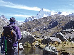
The Paryaqaqa or Waruchiri mountain range is the north-eastern border of the district. One of the highest peaks of the district is Paryaqaqa at 5,750 metres (18,865 ft) above sea level. Other mountains are listed below:[2]
|
|
See also
- Ch'uspiqucha
- P'itiqucha
References
- ^ (in Spanish) Instituto Nacional de Estadística e Informática. Banco de Información Distrital Archived 2008-04-23 at the Wayback Machine. Retrieved April 11, 2008.
- ^ escale.minedu.gob.pe - UGEL map of the Huarochirí Province (Lima Region)
- v
- t
- e

- Districts of Lima Region
- Peru

- Antioquia
- Callahuanca
- Carampoma
- Chicla
- Cuenca
- Huachupampa
- Huanza
- Huarochirí
- Lahuaytambo
- Langa
- Laraos
- Mariatana
- Matucana
- Ricardo Palma
- San Andrés de Tupicocha
- San Antonio
- San Bartolome
- San Damian
- San Juan de Iris
- San Juan de Tantaranche
- San Lorenzo de Quinti
- San Mateo
- San Mateo de Otao
- San Pedro de Casta
- San Pedro de Huancayre
- Sangallaya
- Santa Cruz de Cocachacra
- Santa Eulalia
- Santiago de Anchucaya
- Santiago de Tuna
- Santo Domingo de los Olleros
- Surco
 | This Lima Region geography article is a stub. You can help Wikipedia by expanding it. |
- v
- t
- e
12°08′50″S 76°12′37″W / 12.1472°S 76.2104°W / -12.1472; -76.2104


