List of listed buildings in Eddleston, Scottish Borders
This is a list of listed buildings in the parish of Eddleston in the Scottish Borders, Scotland.
Map all coordinates using OpenStreetMap
Download coordinates as:
- KML
- GPX (all coordinates)
- GPX (primary coordinates)
- GPX (secondary coordinates)
List
| Name | Location | Date Listed | Grid Ref. [note 1] | Geo-coordinates | Notes | LB Number [note 2] | Image |
|---|---|---|---|---|---|---|---|
| Cringletie House, Including Lodges, Walled Garden, Sundial And Dovecot | 55°41′13″N 3°13′10″W / 55.686989°N 3.219549°W / 55.686989; -3.219549 (Cringletie House, Including Lodges, Walled Garden, Sundial And Dovecot) | Category B | 2035 |  Upload another image | |||
| Harehope | 55°41′04″N 3°16′25″W / 55.684445°N 3.273659°W / 55.684445; -3.273659 (Harehope) | Category B | 2039 |  Upload Photo | |||
| Eddleston Bridge Eddleston | 55°42′37″N 3°12′28″W / 55.710288°N 3.207908°W / 55.710288; -3.207908 (Eddleston Bridge Eddleston) | Category C(S) | 2023 | 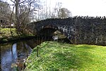 Upload another image | |||
| Portmore | 55°43′37″N 3°11′42″W / 55.727074°N 3.195003°W / 55.727074; -3.195003 (Portmore) | Category A | 2037 | 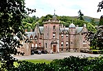 Upload another image | |||
| Summerhouse, Black Barony | 55°42′47″N 3°13′10″W / 55.71297°N 3.219308°W / 55.71297; -3.219308 (Summerhouse, Black Barony) | Category B | 2042 |  Upload another image | |||
| Eddleston Parish Church And Graveyard | 55°42′44″N 3°12′18″W / 55.712322°N 3.204867°W / 55.712322; -3.204867 (Eddleston Parish Church And Graveyard) | Category B | 2020 |  Upload another image | |||
| Entrance Gateway And Lodge, Portmore | 55°43′27″N 3°12′17″W / 55.724094°N 3.204752°W / 55.724094; -3.204752 (Entrance Gateway And Lodge, Portmore) | Category C(S) | 2038 |  Upload another image | |||
| Moredun, And Adjoining 2 Cottages (Glen Nevis And Old School House) | 55°42′45″N 3°12′21″W / 55.71241°N 3.20592°W / 55.71241; -3.20592 (Moredun, And Adjoining 2 Cottages (Glen Nevis And Old School House)) | Category B | 2021 | Upload Photo | |||
| Eddleston Village Nos. 1-23 And 2-22. Station Road | 55°42′40″N 3°12′30″W / 55.711199°N 3.208429°W / 55.711199; -3.208429 (Eddleston Village Nos. 1-23 And 2-22. Station Road) | Category B | 2022 | Upload Photo | |||
| "Bellevue Temple" In Former Policies Of Black Barony | 55°42′39″N 3°13′23″W / 55.710795°N 3.222964°W / 55.710795; -3.222964 ("Bellevue Temple" In Former Policies Of Black Barony) | Category C(S) | 2043 |  Upload another image | |||
| "The Horse Shoe Inn", Eddleston | 55°42′44″N 3°12′23″W / 55.712316°N 3.206331°W / 55.712316; -3.206331 ("The Horse Shoe Inn", Eddleston) | Category C(S) | 157 |  Upload another image | |||
| Black Barony Hotel | 55°42′46″N 3°13′01″W / 55.712814°N 3.216931°W / 55.712814; -3.216931 (Black Barony Hotel) | Category B | 2040 |  Upload another image | |||
| Ice House, Black Barony | 55°42′49″N 3°12′59″W / 55.713555°N 3.216461°W / 55.713555; -3.216461 (Ice House, Black Barony) | Category B | 2041 |  Upload another image |
Key
The scheme for classifying buildings in Scotland is:
- Category A: "buildings of national or international importance, either architectural or historic; or fine, little-altered examples of some particular period, style or building type."[1]
- Category B: "buildings of regional or more than local importance; or major examples of some particular period, style or building type, which may have been altered."[1]
- Category C: "buildings of local importance; lesser examples of any period, style, or building type, as originally constructed or moderately altered; and simple traditional buildings which group well with other listed buildings."[1]
In March 2016 there were 47,288 listed buildings in Scotland. Of these, 8% were Category A, and 50% were Category B, with the remaining 42% being Category C.[2]
Notes
- ^ Sometimes known as OSGB36, the grid reference (where provided) is based on the British national grid reference system used by the Ordnance Survey.
• "Guide to National Grid". Ordnance Survey. Retrieved 12 December 2007.
• "Get-a-map". Ordnance Survey. Retrieved 17 December 2007. - ^ Historic Environment Scotland assign a unique alphanumeric identifier to each designated site in Scotland, for listed buildings this always begins with "LB", for example "LB12345".
References
- All entries, addresses and coordinates are based on data from Historic Scotland. This data falls under the Open Government Licence
- ^ a b c "What is Listing?". Historic Environment Scotland. Retrieved 29 May 2018.
- ^ Scotland's Historic Environment Audit 2016 (PDF). Historic Environment Scotland and the Built Environment Forum Scotland. pp. 15–16. Retrieved 29 May 2018.
- v
- t
- e
- Abbey St Bathans
- Ancrum
- Ashkirk
- Ayton
- Bedrule
- Bowden
- Broughton, Glenholm and Kilbucho
- Bunkle and Preston
- Caddonfoot
- Castleton
- Cavers
- Channelkirk
- Chirnside
- Cockburnspath
- Coldingham
- Coldstream
- Crailing
- Cranshaws
- Drumelzier
- Duns
- Earlston
- Eccles
- Eckford
- Eddleston
- Ednam
- Edrom
- Ettrick
- Eyemouth
- Fala and Soutra
- Fogo
- Foulden
- Galashiels
- Gordon
- Greenlaw
- Hawick
- Heriot
- Hobkirk
- Hownam
- Hume
- Hutton
- Innerleithen
- Jedburgh
- Kelso
- Kirkhope
- Kirkurd
- Ladykirk
- Langton
- Lauder
- Legerwood
- Lilliesleaf
- Linton
- Longformacus
- Lyne
- Makerstoun
- Manor
- Maxton
- Melrose
- Mertoun
- Minto
- Mordington
- Morebattle
- Nenthorn
- Newlands
- Oxnam
- Peebles
- Penicuik
- Polwarth
- Roberton
- Roxburgh
- Selkirk
- Skirling
- Smailholm
- Southdean
- Sprouston
- St Boswells
- Stichill
- Stobo
- Stow
- Swinton
- Teviothead
- Traquair
- Tweedsmuir
- Westruther
- Whitsome
- Yarrow
- Yetholm


