List of listed buildings in Longformacus, Scottish Borders
This is a list of listed buildings in the parish of Longformacus in the Scottish Borders, Scotland.
Map all coordinates using OpenStreetMap
Download coordinates as:
- KML
- GPX (all coordinates)
- GPX (primary coordinates)
- GPX (secondary coordinates)
List
| Name | Location | Date Listed | Grid Ref. [note 1] | Geo-coordinates | Notes | LB Number [note 2] | Image |
|---|---|---|---|---|---|---|---|
| Whitchester House, Main Entrance Including Quadrant Walls, Railings, Piers, Gatepiers, Gates And Turning Point | 55°49′26″N 2°26′52″W / 55.823819°N 2.447648°W / 55.823819; -2.447648 (Whitchester House, Main Entrance Including Quadrant Walls, Railings, Piers, Gatepiers, Gates And Turning Point) | Category B | 45634 |  Upload Photo | |||
| Horseupcleuch Farmhouse Including Boundary Walls | 55°49′10″N 2°32′04″W / 55.81942°N 2.534336°W / 55.81942; -2.534336 (Horseupcleuch Farmhouse Including Boundary Walls) | Category C(S) | 45618 | Upload Photo | |||
| The Millhouse Including Garden Walls, Gatepiers And Gates | 55°48′28″N 2°29′45″W / 55.807713°N 2.495789°W / 55.807713; -2.495789 (The Millhouse Including Garden Walls, Gatepiers And Gates) | Category C(S) | 45624 |  Upload another image | |||
| Riverside Cottage Including Boundary Wall | 55°48′28″N 2°29′31″W / 55.807665°N 2.491975°W / 55.807665; -2.491975 (Riverside Cottage Including Boundary Wall) | Category C(S) | 45626 | Upload Photo | |||
| 4 The Row Including Cobbled Pavement, Nt 6928 5731 | 55°48′29″N 2°29′30″W / 55.807972°N 2.491548°W / 55.807972; -2.491548 (4 The Row Including Cobbled Pavement, Nt 6928 5731) | Category C(S) | 45627 | Upload Photo | |||
| Woodside Cottage Including Sundial | 55°49′52″N 2°25′58″W / 55.830979°N 2.432804°W / 55.830979; -2.432804 (Woodside Cottage Including Sundial) | Category C(S) | 10781 | Upload Photo | |||
| Longformacus House Including Ancillary Structures, Courtyard Gatepiers, Quadrant Walls, Railings, Gatepiers And Gates | 55°48′29″N 2°29′13″W / 55.808054°N 2.486875°W / 55.808054; -2.486875 (Longformacus House Including Ancillary Structures, Courtyard Gatepiers, Quadrant Walls, Railings, Gatepiers And Gates) | Category A | 8344 | 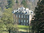 Upload another image | |||
| 13 The Row, Gardener's Cottage Including Cobbled Pavement, Nt 6933 5734 | 55°48′30″N 2°29′27″W / 55.808316°N 2.490962°W / 55.808316; -2.490962 (13 The Row, Gardener's Cottage Including Cobbled Pavement, Nt 6933 5734) | Category C(S) | 45633 | Upload Photo | |||
| Caldra Farmhouse Including Garden Walls | 55°48′24″N 2°28′36″W / 55.806674°N 2.476615°W / 55.806674; -2.476615 (Caldra Farmhouse Including Garden Walls) | Category C(S) | 45616 | Upload Photo | |||
| Longformacus Bridge | 55°48′27″N 2°29′29″W / 55.807568°N 2.491416°W / 55.807568; -2.491416 (Longformacus Bridge) | Category C(S) | 10778 | Upload Photo | |||
| 6 The Row Including Cobbled Pavement, Nt 6931 5733 | 55°48′29″N 2°29′29″W / 55.808126°N 2.491311°W / 55.808126; -2.491311 (6 The Row Including Cobbled Pavement, Nt 6931 5733) | Category C(S) | 45630 | Upload Photo | |||
| 12 The Row Including Cobbled Pavement, Nt 6932 5733 | 55°48′30″N 2°29′28″W / 55.808216°N 2.491152°W / 55.808216; -2.491152 (12 The Row Including Cobbled Pavement, Nt 6932 5733) | Category C(S) | 45631 | Upload Photo | |||
| Achray Cottage | 55°48′24″N 2°29′26″W / 55.806646°N 2.490542°W / 55.806646; -2.490542 (Achray Cottage) | Category C(S) | 45615 | Upload Photo | |||
| Craigie Lodge Including Ancillary Structures, Boundary Walls And Gates | 55°48′31″N 2°30′07″W / 55.80864°N 2.501879°W / 55.80864; -2.501879 (Craigie Lodge Including Ancillary Structures, Boundary Walls And Gates) | Category C(S) | 45617 | Upload Photo | |||
| The Lodge, Longformacus House | 55°48′22″N 2°29′24″W / 55.806092°N 2.489929°W / 55.806092; -2.489929 (The Lodge, Longformacus House) | Category C(S) | 45621 | Upload Photo | |||
| Longformacus House, Walled Garden Including Greenhouse, Sundials, Piers, Stair And Gates | 55°48′32″N 2°29′23″W / 55.808967°N 2.489838°W / 55.808967; -2.489838 (Longformacus House, Walled Garden Including Greenhouse, Sundials, Piers, Stair And Gates) | Category B | 45623 | Upload Photo | |||
| 5 The Row Including Cobbled Pavement, Nt 6930 5732 | 55°48′29″N 2°29′29″W / 55.80809°N 2.491374°W / 55.80809; -2.491374 (5 The Row Including Cobbled Pavement, Nt 6930 5732) | Category C(S) | 45629 | Upload Photo | |||
| Ellemhaugh Smithy Including House, Ancillary Structure (Former Hen House, Byre And Stable) And Former Smithy | 55°49′44″N 2°26′48″W / 55.829007°N 2.446606°W / 55.829007; -2.446606 (Ellemhaugh Smithy Including House, Ancillary Structure (Former Hen House, Byre And Stable) And Former Smithy) | Category C(S) | 10782 | Upload Photo | |||
| Longformacus Church (Church Of Scotland) Including Lampstand, Graveyard And Boundary Walls | 55°48′28″N 2°29′23″W / 55.807719°N 2.489599°W / 55.807719; -2.489599 (Longformacus Church (Church Of Scotland) Including Lampstand, Graveyard And Boundary Walls) | Category B | 8343 | 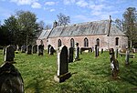 Upload another image | |||
| Whitchester House, Walled Garden Including Stair, Gatepiers And Gate, Greenhouses, Outer Wall And Gatepiers | 55°49′23″N 2°26′58″W / 55.823102°N 2.449571°W / 55.823102; -2.449571 (Whitchester House, Walled Garden Including Stair, Gatepiers And Gate, Greenhouses, Outer Wall And Gatepiers) | Category B | 45635 | Upload Photo | |||
| The Row, Dye Neuk Including Cobbled Pavement, Nt 6929 5732 | 55°48′29″N 2°29′29″W / 55.808035°N 2.491453°W / 55.808035; -2.491453 (The Row, Dye Neuk Including Cobbled Pavement, Nt 6929 5732) | Category C(S) | 45628 | Upload Photo | |||
| Kettleshiel Farm Including Farmhouse, Former Cattle Court, Garden Walls, Ancillary Structures And Boundary Walls | 55°45′33″N 2°28′24″W / 55.759147°N 2.473262°W / 55.759147; -2.473262 (Kettleshiel Farm Including Farmhouse, Former Cattle Court, Garden Walls, Ancillary Structures And Boundary Walls) | Category B | 45620 | Upload Photo | |||
| Longformacus House, Dovecot | 55°48′32″N 2°29′14″W / 55.808762°N 2.487155°W / 55.808762; -2.487155 (Longformacus House, Dovecot) | Category A | 8345 | 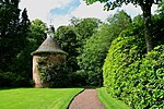 Upload another image | |||
| Ellem Lodge Including Boundary Walls, Gatepiers And Gates | 55°49′54″N 2°26′03″W / 55.831711°N 2.434153°W / 55.831711; -2.434153 (Ellem Lodge Including Boundary Walls, Gatepiers And Gates) | Category B | 8346 | Upload Photo | |||
| Byrecleuch, Former Beater's Cottage, Originally Associated With Old Shooting Lodge | 55°48′51″N 2°35′43″W / 55.814073°N 2.595171°W / 55.814073; -2.595171 (Byrecleuch, Former Beater's Cottage, Originally Associated With Old Shooting Lodge) | Category C(S) | 8348 | Upload Photo | |||
| The Row, The Honey House Including Cobbled Pavement, Nt 6932 5734 | 55°48′30″N 2°29′28″W / 55.808271°N 2.491057°W / 55.808271; -2.491057 (The Row, The Honey House Including Cobbled Pavement, Nt 6932 5734) | Category C(S) | 45632 | Upload Photo | |||
| Horseupcleuch Farm Steading Including Former Millhouse, Former Farmhouse And Shepherd's Cottage | 55°49′13″N 2°32′05″W / 55.820317°N 2.534683°W / 55.820317; -2.534683 (Horseupcleuch Farm Steading Including Former Millhouse, Former Farmhouse And Shepherd's Cottage) | Category C(S) | 45619 | Upload Photo | |||
| Redpath Farmhouse Including Boundary Walls | 55°49′42″N 2°29′48″W / 55.828374°N 2.496802°W / 55.828374; -2.496802 (Redpath Farmhouse Including Boundary Walls) | Category C(S) | 45625 | Upload Photo | |||
| 1 The Row Including Cobbled Pavement, Nt 6927 5729 | 55°48′28″N 2°29′31″W / 55.807809°N 2.491833°W / 55.807809; -2.491833 (1 The Row Including Cobbled Pavement, Nt 6927 5729) | Category C(S) | 10779 | Upload Photo |
Key
The scheme for classifying buildings in Scotland is:
- Category A: "buildings of national or international importance, either architectural or historic; or fine, little-altered examples of some particular period, style or building type."[1]
- Category B: "buildings of regional or more than local importance; or major examples of some particular period, style or building type, which may have been altered."[1]
- Category C: "buildings of local importance; lesser examples of any period, style, or building type, as originally constructed or moderately altered; and simple traditional buildings which group well with other listed buildings."[1]
In March 2016 there were 47,288 listed buildings in Scotland. Of these, 8% were Category A, and 50% were Category B, with the remaining 42% being Category C.[2]
Notes
- ^ Sometimes known as OSGB36, the grid reference (where provided) is based on the British national grid reference system used by the Ordnance Survey.
• "Guide to National Grid". Ordnance Survey. Retrieved 12 December 2007.
• "Get-a-map". Ordnance Survey. Retrieved 17 December 2007. - ^ Historic Environment Scotland assign a unique alphanumeric identifier to each designated site in Scotland, for listed buildings this always begins with "LB", for example "LB12345".
References
- All entries, addresses and coordinates are based on data from Historic Scotland. This data falls under the Open Government Licence
- ^ a b c "What is Listing?". Historic Environment Scotland. Retrieved 29 May 2018.
- ^ Scotland's Historic Environment Audit 2016 (PDF). Historic Environment Scotland and the Built Environment Forum Scotland. pp. 15–16. Retrieved 29 May 2018.
- v
- t
- e
- Abbey St Bathans
- Ancrum
- Ashkirk
- Ayton
- Bedrule
- Bowden
- Broughton, Glenholm and Kilbucho
- Bunkle and Preston
- Caddonfoot
- Castleton
- Cavers
- Channelkirk
- Chirnside
- Cockburnspath
- Coldingham
- Coldstream
- Crailing
- Cranshaws
- Drumelzier
- Duns
- Earlston
- Eccles
- Eckford
- Eddleston
- Ednam
- Edrom
- Ettrick
- Eyemouth
- Fala and Soutra
- Fogo
- Foulden
- Galashiels
- Gordon
- Greenlaw
- Hawick
- Heriot
- Hobkirk
- Hownam
- Hume
- Hutton
- Innerleithen
- Jedburgh
- Kelso
- Kirkhope
- Kirkurd
- Ladykirk
- Langton
- Lauder
- Legerwood
- Lilliesleaf
- Linton
- Longformacus
- Lyne
- Makerstoun
- Manor
- Maxton
- Melrose
- Mertoun
- Minto
- Mordington
- Morebattle
- Nenthorn
- Newlands
- Oxnam
- Peebles
- Penicuik
- Polwarth
- Roberton
- Roxburgh
- Selkirk
- Skirling
- Smailholm
- Southdean
- Sprouston
- St Boswells
- Stichill
- Stobo
- Stow
- Swinton
- Teviothead
- Traquair
- Tweedsmuir
- Westruther
- Whitsome
- Yarrow
- Yetholm


