List of listed buildings in Lilliesleaf, Scottish Borders
This is a list of listed buildings in the parish of Lilliesleaf in the Scottish Borders, Scotland.
Map all coordinates using OpenStreetMap
Download coordinates as:
- KML
- GPX (all coordinates)
- GPX (primary coordinates)
- GPX (secondary coordinates)
List
| Name | Location | Date Listed | Grid Ref. [note 1] | Geo-coordinates | Notes | LB Number [note 2] | Image |
|---|---|---|---|---|---|---|---|
| Lilliesleaf Village, Cockspurs | 55°31′05″N 2°44′15″W / 55.51804°N 2.737569°W / 55.51804; -2.737569 (Lilliesleaf Village, Cockspurs) | Category C(S) | 8199 |  Upload Photo | |||
| Deer Larder, Riddell | 55°30′44″N 2°46′00″W / 55.512254°N 2.766739°W / 55.512254; -2.766739 (Deer Larder, Riddell) | Category B | 8202 |  Upload another image | |||
| Stables, Riddell | 55°30′41″N 2°46′01″W / 55.511291°N 2.76699°W / 55.511291; -2.76699 (Stables, Riddell) | Category B | 8201 | Upload Photo | |||
| Bewlie Old Farm, Bewlie Orchard | 55°31′31″N 2°41′48″W / 55.525171°N 2.696787°W / 55.525171; -2.696787 (Bewlie Old Farm, Bewlie Orchard) | Category B | 43267 | Upload Photo | |||
| Bewlie House With Terrace, Garden Walls And Gates | 55°31′36″N 2°41′49″W / 55.526625°N 2.697034°W / 55.526625; -2.697034 (Bewlie House With Terrace, Garden Walls And Gates) | Category B | 12944 |  Upload another image | |||
| Lilliesleaf Church Of Scotland Kirk Graveyard, Walls And Gravestones | 55°31′09″N 2°43′51″W / 55.51923°N 2.73086°W / 55.51923; -2.73086 (Lilliesleaf Church Of Scotland Kirk Graveyard, Walls And Gravestones) | Category B | 49293 | Upload Photo | |||
| Clerklands | 55°30′51″N 2°47′15″W / 55.514062°N 2.787583°W / 55.514062; -2.787583 (Clerklands) | Category B | 13672 | Upload Photo | |||
| Riddell | 55°30′45″N 2°45′58″W / 55.512419°N 2.76622°W / 55.512419; -2.76622 (Riddell) | Category B | 13669 |  Upload another image | |||
| Lilliesleaf Church Of Scotland Kirk Including Boundary Walls, Gatepiers And Gates | 55°31′10″N 2°43′53″W / 55.519326°N 2.731353°W / 55.519326; -2.731353 (Lilliesleaf Church Of Scotland Kirk Including Boundary Walls, Gatepiers And Gates) | Category B | 8197 |  Upload another image | |||
| Park Bridge, Riddell | 55°30′36″N 2°45′51″W / 55.510078°N 2.764116°W / 55.510078; -2.764116 (Park Bridge, Riddell) | Category B | 8209 |  Upload another image | |||
| Riddell Policies, Mausoleum Including Boundary Wall, Railings And Gates | 55°30′53″N 2°45′42″W / 55.514668°N 2.761529°W / 55.514668; -2.761529 (Riddell Policies, Mausoleum Including Boundary Wall, Railings And Gates) | Category B | 8212 | 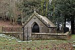 Upload another image | |||
| Riddell Policies, Park Bridge (North) | 55°30′42″N 2°45′55″W / 55.511651°N 2.76535°W / 55.511651; -2.76535 (Riddell Policies, Park Bridge (North)) | Category C(S) | 8210 |  Upload another image | |||
| Manse | 55°31′09″N 2°44′11″W / 55.519044°N 2.736526°W / 55.519044; -2.736526 (Manse) | Category B | 8198 | Upload Photo | |||
| The Riddell Policies, General's Tower | 55°30′55″N 2°45′41″W / 55.515369°N 2.761384°W / 55.515369; -2.761384 (The Riddell Policies, General's Tower) | Category B | 8211 |  Upload another image | |||
| Lilliesleaf Village, Viola Cottage | 55°31′06″N 2°44′11″W / 55.51847°N 2.736357°W / 55.51847; -2.736357 (Lilliesleaf Village, Viola Cottage) | Category C(S) | 8200 | Upload Photo |
Key
The scheme for classifying buildings in Scotland is:
- Category A: "buildings of national or international importance, either architectural or historic; or fine, little-altered examples of some particular period, style or building type."[1]
- Category B: "buildings of regional or more than local importance; or major examples of some particular period, style or building type, which may have been altered."[1]
- Category C: "buildings of local importance; lesser examples of any period, style, or building type, as originally constructed or moderately altered; and simple traditional buildings which group well with other listed buildings."[1]
In March 2016 there were 47,288 listed buildings in Scotland. Of these, 8% were Category A, and 50% were Category B, with the remaining 42% being Category C.[2]
Notes
- ^ Sometimes known as OSGB36, the grid reference (where provided) is based on the British national grid reference system used by the Ordnance Survey.
• "Guide to National Grid". Ordnance Survey. Retrieved 12 December 2007.
• "Get-a-map". Ordnance Survey. Retrieved 17 December 2007. - ^ Historic Environment Scotland assign a unique alphanumeric identifier to each designated site in Scotland, for listed buildings this always begins with "LB", for example "LB12345".
References
- All entries, addresses and coordinates are based on data from Historic Scotland. This data falls under the Open Government Licence
- ^ a b c "What is Listing?". Historic Environment Scotland. Retrieved 29 May 2018.
- ^ Scotland's Historic Environment Audit 2016 (PDF). Historic Environment Scotland and the Built Environment Forum Scotland. pp. 15–16. Retrieved 29 May 2018.
- v
- t
- e
- Abbey St Bathans
- Ancrum
- Ashkirk
- Ayton
- Bedrule
- Bowden
- Broughton, Glenholm and Kilbucho
- Bunkle and Preston
- Caddonfoot
- Castleton
- Cavers
- Channelkirk
- Chirnside
- Cockburnspath
- Coldingham
- Coldstream
- Crailing
- Cranshaws
- Drumelzier
- Duns
- Earlston
- Eccles
- Eckford
- Eddleston
- Ednam
- Edrom
- Ettrick
- Eyemouth
- Fala and Soutra
- Fogo
- Foulden
- Galashiels
- Gordon
- Greenlaw
- Hawick
- Heriot
- Hobkirk
- Hownam
- Hume
- Hutton
- Innerleithen
- Jedburgh
- Kelso
- Kirkhope
- Kirkurd
- Ladykirk
- Langton
- Lauder
- Legerwood
- Lilliesleaf
- Linton
- Longformacus
- Lyne
- Makerstoun
- Manor
- Maxton
- Melrose
- Mertoun
- Minto
- Mordington
- Morebattle
- Nenthorn
- Newlands
- Oxnam
- Peebles
- Penicuik
- Polwarth
- Roberton
- Roxburgh
- Selkirk
- Skirling
- Smailholm
- Southdean
- Sprouston
- St Boswells
- Stichill
- Stobo
- Stow
- Swinton
- Teviothead
- Traquair
- Tweedsmuir
- Westruther
- Whitsome
- Yarrow
- Yetholm


