Mears Peak
Mountain in the state of Colorado


Mears Peak
Location in Colorado
Show map of Colorado
Mears Peak
Mears Peak (the United States)
Show map of the United StatesColorado, US
San Juan Mountains
Sneffels Range[1]
Mears Peak is a 13,496-foot-elevation (4,114-meter) mountain summit located on the common boundary of Ouray County with San Miguel County, in Colorado, United States.[3] It is situated six miles northwest of the community of Telluride, in the Mount Sneffels Wilderness, on land managed by Uncompahgre National Forest. It is part of the Sneffels Range which is a subset of the San Juan Mountains, which in turn is part of the Rocky Mountains. Mears Peak is situated west of the Continental Divide, and 3.8 miles west of Mount Sneffels. Topographic relief is significant as the south aspect rises 4,900 feet (1,500 meters) above the San Miguel River in approximately 5.5 miles.
History
This mountain's name and location were officially adopted in 1970 by the U.S. Board on Geographic Names to commemorate Otto Mears (1840–1931).[3][5] Prior to 1970, the USGS placed Mears Peak at a location one mile to the east.[3] Otto Mears was known for his road and railroad building projects through Colorado's San Juan Mountains, which were instrumental in the early development of southwestern Colorado in the late 19th century.[6] Notably, he built the Million Dollar Highway. There is also a Mount Otto in Colorado named after him.
Climate
According to the Köppen climate classification system, Mears Peak is located in an alpine subarctic climate zone with long, cold, snowy winters, and cool to warm summers.[7] Due to its altitude, it receives precipitation all year, as snow in winter, and as thunderstorms in summer, with a dry period in late spring. Precipitation runoff from the mountain drains south to the San Miguel River, and north to the Uncompahgre River via Dallas Creek.
Gallery
-
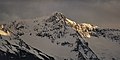
 North aspect
 -
 North aspect
 -
 Northeast aspect
 -
 Mears Peak to left, "S9" to the right
 -
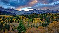 Sneffels Range, Mears Peak to left
 -
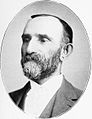 Otto Mears in 1902


See also
 Mountains portal
 Colorado portal


- Mountains of Ouray County, Colorado
- Hayden Peak
References
- ^ a b c "Mears Peak, Colorado". Peakbagger.com.
- ^ a b c "Mears Peak - 13,496' CO". listsofjohn.com. Retrieved 2021-06-27.
- ^ a b c d "Mears Peak". Geographic Names Information System. United States Geological Survey, United States Department of the Interior. Retrieved 2021-06-27.
- ^ Bulletin of the Geological Society of America, Volume 17, 1906, page 262.
- ^ Stewart M. Green, Scenic Driving Colorado: Exploring the State's Most Spectacular Back Roads, 2019, Globe Pequot, ISBN 9781493035991, page 254.
- ^ Williamson, Ruby G. "Otto Mears Pathfinder of the San Juan: His Family and Friends" (Gunnison, 1981).
- ^ Peel, M. C.; Finlayson, B. L.; McMahon, T. A. (2007). "Updated world map of the Köppen−Geiger climate classification". Hydrol. Earth Syst. Sci. 11. ISSN 1027-5606.
External links
- Weather forecast: Mears Peak
- Mears Peak rock climbing: Mountainproject.com
- Mears Peak photo
- v
- t
- e

- Mount Garfield
- Aspen Mountain
- Capitol Peak
- Castle Peak
- Cathedral Peak
- Chair Mountain
- Crested Butte
- Gothic Mountain
- Italian Mountain
- Maroon Bells
- Mount Emmons
- Mount Owen
- Mount Sopris
- Pyramid Peak
- Snowmass Mountain
- Snowmass Peak
- Treasure Mountain
- Black Mountain (Moffat County)
- Columbus Mountain
- Elk Mountain (Routt County)
- Hahns Peak
- Flat Top Mountain
- Sleepy Cat Peak
- Eagles Nest
- Jacque Peak
- Meridian Peak
- Mount Powell
- The Spider
- Crater Peak
- North Mamm Peak
- Clark Peak
- Arkansas Hills
- Clinton Peak
- Dyer Mountain
- Gemini Peak
- Horseshoe Mountain
- Mount Arkansas
- Mount Bross
- Mount Buckskin
- Mount Democrat
- Mount Lincoln
- Mount Sheridan
- Mount Sherman
- Pacific Peak
- West Buffalo Peak
- Elk Mountain (Grand County)
- Parkview Mountain
- Radial Mountain
- Whiteley Peak
| Sangre de Cristo Range |
|
|---|---|
| Wet Mountains |
|
| Others |
|
| Collegiate Peaks |
|
|---|---|
| Others |
|
- Crystal Peak
- Fletcher Mountain
- Peak 10
- Peak One
- Quandary Peak
- Tenmile Peak
- Bear Mountain
- Blair Mountain
- Chalk Mountains
- Cochetopa Hills
- Dawson Butte
- Diamond Peak
- Flirtation Peak
- Granite Peak
- Grand Hogback
- Grannys Nipple
- Horsefly Peak
- Lead Mountain (Grand County)
- Mount Neva
- Powell Peak
- San Luis Hills
- Storm King Mountain
- Terrible Mountain
- Two Buttes
- Ute Mountain


