Mount Eolus
Mountain in Colorado, United States


Mount Eolus
Location in Colorado
Needle Mountains[2]
Columbine Pass, Colorado[3]
Mount Eolus is a high mountain summit of the Needle Mountains range of the Rocky Mountains of North America. The 14,090-foot (4,295 m) fourteener is located in the Weminuche Wilderness of San Juan National Forest, 27.4 miles (44.1 km) northeast by north (bearing 29°) of the City of Durango in La Plata County, Colorado, United States.[1][2][3]
Named after the Greek god of the wind, the mountain was originally referred to as "Aeolus" in the 1874 Hayden Survey.[5] The current spelling of "Eolus" was first used in the Wheeler Survey of 1878.[6]
Climbing
Mount Eolus is one of three fourteeners in the Needle Mountains; the others are Sunlight Peak and Windom Peak. All three peaks are located around the cirque known as Upper Chicago Basin. Eolus lies to the west of the upper basin, while the other peaks lie on the east side. These mountains are among the most remote of Colorado's fourteeners and have a strong wilderness character.
North Eolus, elevation 14,045 ft (4,281 m), is a northern subpeak of Mount Eolus, though it is not usually counted as a separate peak or as an official fourteener, since it has a topographic prominence of only 179 ft (55 m).[7] It is sometimes climbed in conjunction with Eolus.[8]
Climate
| Climate data for Mount Eolus 37.6271 N, 107.6151 W, Elevation: 13,333 ft (4,064 m) (1991–2020 normals) | |||||||||||||
|---|---|---|---|---|---|---|---|---|---|---|---|---|---|
| Month | Jan | Feb | Mar | Apr | May | Jun | Jul | Aug | Sep | Oct | Nov | Dec | Year |
| Mean daily maximum °F (°C) | 25.2 (−3.8) | 24.9 (−3.9) | 29.4 (−1.4) | 34.2 (1.2) | 42.6 (5.9) | 54.2 (12.3) | 58.6 (14.8) | 56.5 (13.6) | 50.8 (10.4) | 41.4 (5.2) | 31.8 (−0.1) | 25.4 (−3.7) | 39.6 (4.2) |
| Daily mean °F (°C) | 13.3 (−10.4) | 12.6 (−10.8) | 16.8 (−8.4) | 21.3 (−5.9) | 29.9 (−1.2) | 40.5 (4.7) | 45.4 (7.4) | 43.9 (6.6) | 38.2 (3.4) | 29.0 (−1.7) | 20.3 (−6.5) | 13.8 (−10.1) | 27.1 (−2.7) |
| Mean daily minimum °F (°C) | 1.4 (−17.0) | 0.4 (−17.6) | 4.1 (−15.5) | 8.4 (−13.1) | 17.2 (−8.2) | 26.9 (−2.8) | 32.2 (0.1) | 31.2 (−0.4) | 25.5 (−3.6) | 16.6 (−8.6) | 8.8 (−12.9) | 2.3 (−16.5) | 14.6 (−9.7) |
| Average precipitation inches (mm) | 4.80 (122) | 4.95 (126) | 4.65 (118) | 4.72 (120) | 3.52 (89) | 1.30 (33) | 2.46 (62) | 3.99 (101) | 3.19 (81) | 3.99 (101) | 4.54 (115) | 4.99 (127) | 47.1 (1,195) |
| Source: PRISM Climate Group[9] | |||||||||||||
See also
Portals:
 North America
 United States
 Colorado
 Mountains


Gallery
-
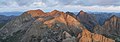 Mount Eolus seen from Sunlight Peak.
 -
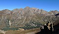 Southeast aspect
 -
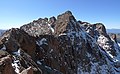 Summit


References
- ^ a b The elevation of Mount Eolus includes an adjustment of +1.756 m (+5.76 ft) from NGVD 29 to NAVD 88.
- ^ a b c d e "Mount Eolus, Colorado". Peakbagger.com. Retrieved October 20, 2014.
- ^ a b c d "Mount Eolus". Geographic Names Information System. United States Geological Survey, United States Department of the Interior. Retrieved October 20, 2014.
- ^ "Mt. Eolus Routes". 14ers.com.
- ^ Dziezynski, James (1 August 2012). Best Summit Hikes in Colorado: An Opinionated Guide to 50+ Ascents of Classic and Little-Known Peaks from 8,144 to 14,433 Feet. Wilderness Press. p. 275. ISBN 978-0-89997-713-3.
- ^ Bright, William (1993). Colorado Place Names. Boulder, Colo.: Johnson Books. ISBN 1-55566-102-5.
- ^ "North Eolus, Colorado". Summits of the World. peakbagger.com. Retrieved September 29, 2014.
- ^ Louis W. Dawson II (1996). Dawson's Guide to Colorado's Fourteeners, Volume 2. Blue Clover Press. ISBN 0-9628867-2-6.
- ^ "PRISM Climate Group, Oregon State University". PRISM Climate Group, Oregon State University. Retrieved October 10, 2023.
To find the table data on the PRISM website, start by clicking Coordinates (under Location); copy Latitude and Longitude figures from top of table; click Zoom to location; click Precipitation, Minimum temp, Mean temp, Maximum temp; click 30-year normals, 1991-2020; click 800m; click Retrieve Time Series button.
External links
Wikimedia Commons has media related to Mount Eolus.
- "North Eolus". 14ers.com.
- Mount Eolus on Summitpost
- v
- t
- e

- Mount Garfield
- Aspen Mountain
- Capitol Peak
- Castle Peak
- Cathedral Peak
- Chair Mountain
- Crested Butte
- Gothic Mountain
- Italian Mountain
- Maroon Bells
- Mount Emmons
- Mount Owen
- Mount Sopris
- Pyramid Peak
- Snowmass Mountain
- Snowmass Peak
- Treasure Mountain
- Black Mountain (Moffat County)
- Columbus Mountain
- Elk Mountain (Routt County)
- Hahns Peak
- Flat Top Mountain
- Sleepy Cat Peak
- Eagles Nest
- Jacque Peak
- Meridian Peak
- Mount Powell
- The Spider
- Crater Peak
- North Mamm Peak
- Clark Peak
- Arkansas Hills
- Clinton Peak
- Dyer Mountain
- Gemini Peak
- Horseshoe Mountain
- Mount Arkansas
- Mount Bross
- Mount Buckskin
- Mount Democrat
- Mount Lincoln
- Mount Sheridan
- Mount Sherman
- Pacific Peak
- West Buffalo Peak
- Elk Mountain (Grand County)
- Parkview Mountain
- Radial Mountain
- Whiteley Peak
| Sangre de Cristo Range |
|
|---|---|
| Wet Mountains |
|
| Others |
|
| Collegiate Peaks |
|
|---|---|
| Others |
|
- Crystal Peak
- Fletcher Mountain
- Peak 10
- Peak One
- Quandary Peak
- Tenmile Peak
- Bear Mountain
- Blair Mountain
- Chalk Mountains
- Cochetopa Hills
- Dawson Butte
- Diamond Peak
- Flirtation Peak
- Granite Peak
- Grand Hogback
- Grannys Nipple
- Horsefly Peak
- Lead Mountain (Grand County)
- Mount Neva
- Powell Peak
- San Luis Hills
- Storm King Mountain
- Terrible Mountain
- Two Buttes
- Ute Mountain
| |
|---|---|
|
| |
|---|---|
|


