Peak One
Mountain in the American state of Colorado


Peak One
Location in Colorado
Show map of Colorado
Peak One
Peak One (the United States)
Show map of the United StatesTenmile Range[5]
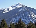
Peak One is a 12,805-foot (3,903 m) mountain summit in Summit County, Colorado, United States.
Description
Peak One is set 15 miles (24 km) west of the Continental Divide at the northern end of the Tenmile Range which is a subrange of the Rocky Mountains.[5] The mountain is located 2.5 miles (4.0 km) south of the community of Frisco,[4] and is set on land managed by Arapaho National Forest.[2] Interstate 70 runs along the western base of the peak. Precipitation runoff from the mountain's west slope drains into Tenmile Creek and the east slope drains to Miners Creek, which both empty into Dillon Reservoir. Topographic relief is significant as the summit rises 3,400 feet (1,036 m) above Tenmile Creek in one mile (1.6 km). The mountain's toponym has been officially adopted by the United States Board on Geographic Names in favor of rejected variant names such as "Peak 1", "Peak Number One", "Tenmile Range Peak 1", and "Melzer Peak."[4]
Climate
According to the Köppen climate classification system, Peak 1 is located in an alpine subarctic climate zone with cold, snowy winters, and cool to warm summers.[7] Due to its altitude, it receives precipitation all year, as snow in winter and as thunderstorms in summer, with a dry period in late spring. The months of June through September offer the most favorable conditions for climbing Peak One.[2]
Gallery
-
 Peak One (centered) with Tenmile Peak to left
 -
 Tenmile Peak (left of center) and Peak 1
 -
 Peak One viewed from the scenic lookout near Frisco, CO.
 -
 Tenmile Peak (center) and Peak 1 (right of center) beyond Dillon Reservoir


See also
 Mountains portal
- List of mountain peaks of Colorado

References
- ^ Randy Jacobs, Robert Ormes (2000), Guide to the Colorado Mountains, Colorado Mountain Club Press, ISBN 9780967146607, p. 162.
- ^ a b c James Dziezynski (2016), Best Summit Hikes Denver to Vail, Wilderness Press, ISBN 9780899978123, p. 121–123.
- ^ a b c d "Peak 1 - 12,805' CO". listsofjohn.com. Retrieved April 17, 2023.
- ^ a b c "Peak One". Geographic Names Information System. United States Geological Survey, United States Department of the Interior. Retrieved April 17, 2023.
- ^ a b "Peak 1, Colorado". Peakbagger.com. Retrieved April 17, 2023.
- ^ a b Max H. Bergendahl (1963), Geology of the Northern Part of the Tenmile Range, Summit County Colorado, Geological Survey Bulletin 1162-D, US Government Printing Office.
- ^ Peel, M. C.; Finlayson, B. L.; McMahon, T. A. (2007). "Updated world map of the Köppen−Geiger climate classification". Hydrol. Earth Syst. Sci. 11. ISSN 1027-5606.
External links
- Peak One: weather forecast
Places adjacent to Peak One | ||||||||||||||||
|---|---|---|---|---|---|---|---|---|---|---|---|---|---|---|---|---|
| ||||||||||||||||


- v
- t
- e

- Mount Garfield
- Aspen Mountain
- Capitol Peak
- Castle Peak
- Cathedral Peak
- Chair Mountain
- Crested Butte
- Gothic Mountain
- Italian Mountain
- Maroon Bells
- Mount Emmons
- Mount Owen
- Mount Sopris
- Pyramid Peak
- Snowmass Mountain
- Snowmass Peak
- Treasure Mountain
- Black Mountain (Moffat County)
- Columbus Mountain
- Elk Mountain (Routt County)
- Hahns Peak
- Flat Top Mountain
- Sleepy Cat Peak
- Eagles Nest
- Jacque Peak
- Meridian Peak
- Mount Powell
- The Spider
- Crater Peak
- North Mamm Peak
- Clark Peak
- Arkansas Hills
- Clinton Peak
- Dyer Mountain
- Gemini Peak
- Horseshoe Mountain
- Mount Arkansas
- Mount Bross
- Mount Buckskin
- Mount Democrat
- Mount Lincoln
- Mount Sheridan
- Mount Sherman
- Pacific Peak
- West Buffalo Peak
- Elk Mountain (Grand County)
- Parkview Mountain
- Radial Mountain
- Whiteley Peak
| Sangre de Cristo Range |
|
|---|---|
| Wet Mountains |
|
| Others |
|
| Collegiate Peaks |
|
|---|---|
| Others |
|
- Crystal Peak
- Fletcher Mountain
- Peak 10
- Peak One
- Quandary Peak
- Tenmile Peak
- Bear Mountain
- Blair Mountain
- Chalk Mountains
- Cochetopa Hills
- Dawson Butte
- Diamond Peak
- Flirtation Peak
- Granite Peak
- Grand Hogback
- Grannys Nipple
- Horsefly Peak
- Lead Mountain (Grand County)
- Mount Neva
- Powell Peak
- San Luis Hills
- Storm King Mountain
- Terrible Mountain
- Two Buttes
- Ute Mountain


