Mount Moss
Mountain in the state of Colorado


Mount Moss
Location in Colorado
Show map of Colorado
Mount Moss
Mount Moss (the United States)
Show map of the United StatesSan Juan Mountains
La Plata Mountains[2]
Mount Moss is a 13,192-foot-elevation (4,021-meter) mountain summit on the common boundary shared by La Plata County and Montezuma County in Colorado.[4]
Description
Mount Moss is located 16 miles (26 km) northwest of the community of Durango on land managed by San Juan National Forest. It ranks as the third-highest summit of the La Plata Mountains which are a subrange of the Rocky Mountains.[2] Precipitation runoff from the mountain's west slope drains to the Mancos River, the southeast slope drains to the La Plata River, and the northeast slope drains into the headwaters of Bear Creek which is a tributary of the Dolores River. Topographic relief is significant as the summit rises 3,500 feet (1,100 meters) above the La Plata River in two miles (3.2 km) and 1,600 feet (490 meters) above Owen Basin in one-half mile (0.8 km). Neighbors include Centennial Peak, 0.57 miles (0.92 km) to the north, Lavender Peak, 0.23 miles (0.37 km) to the northwest, and Hesperus Mountain 0.72 miles (1.16 km) to the northwest.[2]
Etymology
The mountain's toponym has been officially adopted by the United States Board on Geographic Names.[4] The name was applied by Ferdinand Vandeveer Hayden circa 1875 to honor John Thomas Moss (1839–1880), an American frontiersman, prospector, and miner.[5] John Moss was the founder of Parrott City which was six miles south of the peak. Moss and E.H. Cooper platted the townsite in 1874 and by 1876 it had 50 buildings, a courthouse and two sawmills.[6]
Climate
According to the Köppen climate classification system, Mount Moss has an alpine climate with cold, snowy winters, and cool to warm summers.[7] Due to its altitude, it receives precipitation all year, as snow in winter and as thunderstorms in summer, with a dry period in late spring.
Gallery
-
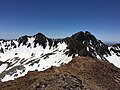 Mount Moss (left) and Lavender Peak (right) viewed from Centennial Peak
 -
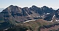 Aerial from west: Hesperus, Lavender, Moss
 -
 Hesperus Mountain (left) and Mount Moss (center) from the west at sunset


See also
 Mountains portal
- Thirteener

References
- ^ Robert M. Ormes (2000), Guide to the Colorado Mountains, Colorado Mountain Club Press, ISBN 9780967146607, p. 321.
- ^ a b c d e f "Mount Moss, Colorado". Peakbagger.com. Retrieved May 21, 2023.
- ^ a b "Moss, Mount - 13,194' CO". listsofjohn.com. Retrieved May 21, 2023.
- ^ a b c d "Mount Moss". Geographic Names Information System. United States Geological Survey, United States Department of the Interior. Retrieved May 21, 2023.
- ^ Ferdinand Vandeveer Hayden (1877), Ninth Annual Report of the United States Geological and Geographical Survey of the Territories, Embracing Colorado and Parts of Adjacent Territories, US Government Printing Office, p. 268.
- ^ Parrott City, Animasmuseum.org Retrieved May 21, 2023
- ^ Peel, M. C.; Finlayson, B. L.; McMahon, T. A. (2007). "Updated world map of the Köppen−Geiger climate classification". Hydrol. Earth Syst. Sci. 11. ISSN 1027-5606.
External links
- Weather forecast: Mount Moss
- John Thomas Moss (photo): Animasmuseum.org
Places adjacent to Mount Moss | ||||||||||||||||
|---|---|---|---|---|---|---|---|---|---|---|---|---|---|---|---|---|
| ||||||||||||||||


- v
- t
- e

- Mount Garfield
- Aspen Mountain
- Capitol Peak
- Castle Peak
- Cathedral Peak
- Chair Mountain
- Crested Butte
- Gothic Mountain
- Italian Mountain
- Maroon Bells
- Mount Emmons
- Mount Owen
- Mount Sopris
- Pyramid Peak
- Snowmass Mountain
- Snowmass Peak
- Treasure Mountain
- Black Mountain (Moffat County)
- Columbus Mountain
- Elk Mountain (Routt County)
- Hahns Peak
- Flat Top Mountain
- Sleepy Cat Peak
- Eagles Nest
- Jacque Peak
- Meridian Peak
- Mount Powell
- The Spider
- Crater Peak
- North Mamm Peak
- Clark Peak
- Arkansas Hills
- Clinton Peak
- Dyer Mountain
- Gemini Peak
- Horseshoe Mountain
- Mount Arkansas
- Mount Bross
- Mount Buckskin
- Mount Democrat
- Mount Lincoln
- Mount Sheridan
- Mount Sherman
- Pacific Peak
- West Buffalo Peak
- Elk Mountain (Grand County)
- Parkview Mountain
- Radial Mountain
- Whiteley Peak
| Sangre de Cristo Range |
|
|---|---|
| Wet Mountains |
|
| Others |
|
| Collegiate Peaks |
|
|---|---|
| Others |
|
- Crystal Peak
- Fletcher Mountain
- Peak 10
- Peak One
- Quandary Peak
- Tenmile Peak
- Bear Mountain
- Blair Mountain
- Chalk Mountains
- Cochetopa Hills
- Dawson Butte
- Diamond Peak
- Flirtation Peak
- Granite Peak
- Grand Hogback
- Grannys Nipple
- Horsefly Peak
- Lead Mountain (Grand County)
- Mount Neva
- Powell Peak
- San Luis Hills
- Storm King Mountain
- Terrible Mountain
- Two Buttes
- Ute Mountain


