National Register of Historic Places listings in Culberson County, Texas

This is a list of the National Register of Historic Places listings in Culberson County, Texas.
This is intended to be a complete list of properties and districts listed on the National Register of Historic Places in Culberson County, Texas. There are two districts and eight individual properties listed on the National Register in the county.
This National Park Service list is complete through NPS recent listings posted July 12, 2024.[1]
Current listings
Map all coordinates using OpenStreetMap
Download coordinates as:
- KML
- GPX (all coordinates)
- GPX (primary coordinates)
- GPX (secondary coordinates)
The publicly disclosed locations of National Register properties and districts may be seen in a mapping service provided.[2]
| [3] | Name on the Register | Image | Date listed[4] | Location | City or town | Description |
|---|---|---|---|---|---|---|
| 1 | Butterfield Overland Mail Corridor |  | August 27, 2014 (#14000524) | 400 Pine Canyon Road. (Guadalupe Mountains National Park) 31°53′36″N 104°48′57″W / 31.8934°N 104.8159°W / 31.8934; -104.8159 (Butterfield Overland Mail Corridor) | Salt Flat vicinity | Extends into Hudspeth County. |
| 2 | Clark Hotel |  | July 19, 1979 (#79002929) | 112 Broadway St. 31°02′24″N 104°49′55″W / 31.040069°N 104.831944°W / 31.040069; -104.831944 (Clark Hotel) | Van Horn | Recorded Texas Historic Landmark |
| 3 | First Presbyterian Church | 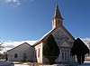 | December 1, 1978 (#78002912) | Fannin and 3rd Sts. 31°02′33″N 104°50′05″W / 31.0425°N 104.834792°W / 31.0425; -104.834792 (First Presbyterian Church) | Van Horn | Recorded Texas Historic Landmark |
| 4 | Granado Cave |  | March 25, 1977 (#77001436) | Address restricted[5] | Toyah | |
| 5 | Guadalupe Ranch | 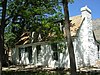 | November 21, 1978 (#78000259) | Northeast of Salt Flat in Guadalupe Mountains National Park 31°54′27″N 104°48′00″W / 31.9075°N 104.8°W / 31.9075; -104.8 (Guadalupe Ranch) | Salt Flat | Frijole Ranch, also known as Guadalupe Ranch, Spring Hill Ranch and the Rader-Smith Ranch. |
| 6 | Lobo Valley Petroglyph Site |  | October 25, 1988 (#88002012) | Address restricted[5] | Lobo | |
| 7 | McKittrick Canyon Archeological District, Guadalupe Mountains National Park |  | September 26, 1991 (#91001381) | Guadalupe Mountains National Park 31°58′45″N 104°45′17″W / 31.9792°N 104.7547°W / 31.9792; -104.7547 (McKittrick Canyon Archeological District, Guadalupe Mountains National Park) | Salt Flat | |
| 8 | Pinery Station |  | October 9, 1974 (#74000281) | Off US 62 / US 180 31°53′38″N 104°49′01″W / 31.893889°N 104.816944°W / 31.893889; -104.816944 (Pinery Station) | Guadalupe Mountains National Park | |
| 9 | Wallace E. Pratt House |  | December 15, 2011 (#11000927) | Pratt Dr. at McKittrick Rd. 31°57′29″N 104°45′32″W / 31.958111°N 104.759°W / 31.958111; -104.759 (Wallace E. Pratt House) | Salt Flat vicinity | |
| 10 | Wallace Pratt Lodge | 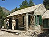 | March 26, 1975 (#75000154) | At junction of north and south branch of McKittrick Canyon 31°59′01″N 104°46′50″W / 31.983611°N 104.780556°W / 31.983611; -104.780556 (Wallace Pratt Lodge) | Guadalupe Mountains National Park |
See also
 National Register of Historic Places portal
 Texas portal


- National Register of Historic Places listings in Guadalupe Mountains National Park
- National Register of Historic Places listings in Texas
- Recorded Texas Historic Landmarks in Culberson County
References
- ^ National Park Service, United States Department of the Interior, "National Register of Historic Places: Weekly List Actions", retrieved July 12, 2024.
- ^ The latitude and longitude information provided in this table was derived originally from the National Register Information System, which has been found to be fairly accurate for about 99% of listings. Some locations in this table may have been corrected to current GPS standards.
- ^ Numbers represent an alphabetical ordering by significant words. Various colorings, defined here, differentiate National Historic Landmarks and historic districts from other NRHP buildings, structures, sites or objects.
- ^ The eight-digit number below each date is the number assigned to each location in the National Register Information System database, which can be viewed by clicking the number.
- ^ a b Federal and state laws and practices restrict general public access to information regarding the specific location of this resource. In some cases, this is to protect archeological sites from vandalism, while in other cases it is restricted at the request of the owner. See: Knoerl, John; Miller, Diane; Shrimpton, Rebecca H. (1990), Guidelines for Restricting Information about Historic and Prehistoric Resources, National Register Bulletin, National Park Service, U.S. Department of the Interior, OCLC 20706997.
External links
![]() Media related to National Register of Historic Places in Culberson County, Texas at Wikimedia Commons
Media related to National Register of Historic Places in Culberson County, Texas at Wikimedia Commons
- v
- t
- e
by county
- Anderson
- Andrews
- Angelina
- Aransas
- Archer
- Armstrong
- Atascosa
- Austin
- Bailey
- Bandera
- Bastrop
- Baylor
- Bee
- Bell
- Bexar
- Blanco
- Borden
- Bosque
- Bowie
- Brazoria
- Brazos
- Brewster
- Briscoe
- Brooks
- Brown
- Burleson
- Burnet
- Caldwell
- Calhoun
- Callahan
- Cameron
- Camp
- Carson
- Cass
- Castro
- Chambers
- Cherokee
- Childress
- Clay
- Cochran
- Coke
- Coleman
- Collin
- Collingsworth
- Colorado
- Comal
- Comanche
- Concho
- Cooke
- Coryell
- Cottle
- Crane
- Crockett
- Crosby
- Culberson
- Dallam
- Dallas
- Dawson
- Deaf Smith
- Delta
- Denton
- DeWitt
- Dickens
- Dimmit
- Donley
- Duval
- Eastland
- Ector
- Edwards
- El Paso
- Ellis
- Erath
- Falls
- Fannin
- Fayette
- Fisher
- Floyd
- Foard
- Fort Bend
- Franklin
- Freestone
- Frio
- Gaines
- Galveston
- Garza
- Gillespie
- Glasscock
- Goliad
- Gonzales
- Gray
- Grayson
- Gregg
- Grimes
- Guadalupe
- Hale
- Hall
- Hamilton
- Hansford
- Hardeman
- Hardin
- Harris
- Harrison
- Hartley
- Haskell
- Hays
- Hemphill
- Henderson
- Hidalgo
- Hill
- Hockley
- Hood
- Hopkins
- Houston
- Howard
- Hudspeth
- Hunt
- Hutchinson
- Irion
- Jack
- Jackson
- Jasper
- Jeff Davis
- Jefferson
- Jim Hogg
- Jim Wells
- Johnson
- Jones
- Karnes
- Kaufman
- Kendall
- Kenedy
- Kent
- Kerr
- Kimble
- King
- Kinney
- Kleberg
- Knox
- La Salle
- Lamar
- Lamb
- Lampasas
- Lavaca
- Lee
- Leon
- Liberty
- Limestone
- Lipscomb
- Live Oak
- Llano
- Loving
- Lubbock
- Lynn
- Madison
- Marion
- Martin
- Mason
- Matagorda
- Maverick
- McCulloch
- McLennan
- McMullen
- Medina
- Menard
- Midland
- Milam
- Mills
- Mitchell
- Montague
- Montgomery
- Moore
- Morris
- Motley
- Nacogdoches
- Navarro
- Newton
- Nolan
- Nueces
- Ochiltree
- Oldham
- Orange
- Palo Pinto
- Panola
- Parker
- Parmer
- Pecos
- Polk
- Potter
- Presidio
- Rains
- Randall
- Reagan
- Real
- Red River
- Reeves
- Refugio
- Roberts
- Robertson
- Rockwall
- Runnels
- Rusk
- Sabine
- San Augustine
- San Jacinto
- San Patricio
- San Saba
- Schleicher
- Scurry
- Shackelford
- Shelby
- Sherman
- Smith
- Somervell
- Starr
- Stephens
- Sterling
- Stonewall
- Sutton
- Swisher
- Tarrant
- Taylor
- Terrell
- Terry
- Throckmorton
- Titus
- Tom Green
- Travis
- Trinity
- Tyler
- Upshur
- Upton
- Uvalde
- Val Verde
- Van Zandt
- Victoria
- Walker
- Waller
- Ward
- Washington
- Webb
- Wharton
- Wheeler
- Wichita
- Wilbarger
- Willacy
- Williamson
- Wilson
- Winkler
- Wise
- Wood
- Yoakum
- Young
- Zapata
- Zavala

Municipalities and communities of Culberson County, Texas, United States | ||
|---|---|---|
County seat: Van Horn | ||
| Town |  | |
| Unincorporated communities |
| |
| Ghost town | ||
| ||


