National Register of Historic Places listings in Smith County, Texas

This is a list of the National Register of Historic Places listings in Smith County, Texas.
This is intended to be a complete list of properties and districts listed on the National Register of Historic Places in Smith County, Texas. There are seven districts and 28 individual properties listed on the National Register in the county. Three individually listed properties are State Antiquities Landmarks two of which, along with six others, are Recorded Texas Historic Landmarks. Three districts contain additional Recorded Texas Historic Landmarks.
This National Park Service list is complete through NPS recent listings posted July 12, 2024.[1]
Current listings
Map all coordinates using OpenStreetMap
Download coordinates as:
- KML
- GPX (all coordinates)
- GPX (primary coordinates)
- GPX (secondary coordinates)
The locations of National Register properties and districts may be seen in a mapping service provided.[2]
| [3] | Name on the Register | Image | Date listed[4] | Location | City or town | Description |
|---|---|---|---|---|---|---|
| 1 | Azalea Residential Historic District |  | June 23, 2003 (#03000559) | Roughly bounded by S. Robertson Av., Sunnybrook Dr., Fair Ln., Old Bullard Rd., College Av., W. 4th St., Highland Av.. 32°19′40″N 95°18′06″W / 32.327778°N 95.301667°W / 32.327778; -95.301667 (Azalea Residential Historic District) | Tyler | Includes Recorded Texas Historic Landmark; Historic and Architectural Resources of Tyler MPS |
| 2 | Blackstone Building |  | June 14, 2002 (#02000645) | 315 N. Broadway 32°21′12″N 95°18′02″W / 32.35343°N 95.30045°W / 32.35343; -95.30045 (Blackstone Building) | Tyler | Historic and Architectural Resources of Tyler MPS |
| 3 | Brick Streets Neighborhood Historic District |  | April 28, 2004 (#04000379) | Roughly bounded by South Broadway, W. Dobbs St., S. Kennedy Ave., S. Vine Ave., Interior Property Lines, S. College Ave. 32°20′33″N 95°18′16″W / 32.3425°N 95.304444°W / 32.3425; -95.304444 (Brick Streets Neighborhood Historic District) | Tyler | Includes Recorded Texas Historic Landmarks; Historic and Architectural Resources of Tyler MPS |
| 4 | Campbell Building-Union Bus Station | Upload image | January 19, 2023 (#100008548) | 311 North Bois d' Arc Ave. 32°21′05″N 95°18′10″W / 32.3514°N 95.3028°W / 32.3514; -95.3028 (Campbell Building-Union Bus Station) | Tyler | |
| 5 | Carnegie Public Library |  | March 26, 1979 (#79003007) | 125 S. College St. 32°21′00″N 95°18′07″W / 32.35°N 95.301944°W / 32.35; -95.301944 (Carnegie Public Library) | Tyler | State Antiquities Landmark, Recorded Texas Historic Landmark |
| 6 | Charnwood Residential Historic District |  | August 20, 1999 (#99001023) | Roughly bounded by E Houston, RR tracks, E Wells, S Donnybrook, E Dobbs, and S Broadway 32°20′28″N 95°17′50″W / 32.341111°N 95.297222°W / 32.341111; -95.297222 (Charnwood Residential Historic District) | Tyler | Includes Recorded Texas Historic Landmark |
| 7 | Cotton Belt Building | 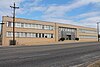 | December 6, 2005 (#05001405) | 1517 W. Front St. 32°20′49″N 95°19′03″W / 32.34686°N 95.31762°W / 32.34686; -95.31762 (Cotton Belt Building) | Tyler | |
| 8 | Crescent Laundry |  | June 14, 2002 (#02000644) | 312-320 E. Ferguson St. 32°21′07″N 95°17′51″W / 32.35189°N 95.29761°W / 32.35189; -95.29761 (Crescent Laundry) | Tyler | Historic and Architectural Resources of Tyler MPS |
| 9 | Col. John Dewberry House | 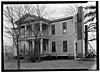 | May 6, 1971 (#71000963) | 1 mi (1.6 km). N of Teaselville on FM 346 32°09′32″N 95°24′17″W / 32.15898°N 95.40460°W / 32.15898; -95.40460 (Col. John Dewberry House) | Teaselville | Recorded Texas Historic Landmark |
| 10 | Donnybrook Duplex Residential Historic District |  | June 14, 2002 (#02000649) | Roughly bounded by E. 6th St., Donnybrook Ave., E. 8th St., and S. Wall 32°19′42″N 95°17′48″W / 32.328333°N 95.296667°W / 32.328333; -95.296667 (Donnybrook Duplex Residential Historic District) | Tyler | Historic and Architectural Resources of Tyler MPS |
| 11 | John B. and Ketura (Kettie) Douglas House | 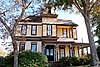 | January 9, 1997 (#96001565) | 318 S. Fannin Ave. 32°20′51″N 95°17′54″W / 32.34742°N 95.29825°W / 32.34742; -95.29825 (John B. and Ketura (Kettie) Douglas House) | Tyler | Recorded Texas Historic Landmark |
| 12 | East Ferguson Residential Historic District |  | June 14, 2002 (#02000647) | 423-513 E. Ferguson St. 32°21′04″N 95°17′45″W / 32.351111°N 95.295833°W / 32.351111; -95.295833 (East Ferguson Residential Historic District) | Tyler | Historic and Architectural Resources of Tyler MPS |
| 13 | Elks Club Building |  | June 14, 2002 (#02000648) | 202 S. Broadway 32°20′58″N 95°18′01″W / 32.34941°N 95.30039°W / 32.34941; -95.30039 (Elks Club Building) | Tyler | Historic and Architectural Resources of Tyler MPS |
| 14 | D.R. Glass Library at Texas College |  | March 7, 2007 (#07000128) | 2404 N. Grand Ave. 32°22′25″N 95°18′44″W / 32.373611°N 95.312222°W / 32.373611; -95.312222 (D.R. Glass Library at Texas College) | Tyler | |
| 15 | Goodman-LeGrand House |  | November 7, 1976 (#76002066) | 624 N. Broadway 32°21′24″N 95°18′05″W / 32.356667°N 95.301389°W / 32.356667; -95.301389 (Goodman-LeGrand House) | Tyler | State Antiquities Landmark, Recorded Texas Historic Landmark |
| 16 | Jenkins-Harvey Super Service Station and Garage |  | June 14, 2002 (#02000646) | 124 S. College 32°20′59″N 95°18′06″W / 32.34978°N 95.30158°W / 32.34978; -95.30158 (Jenkins-Harvey Super Service Station and Garage) | Tyler | Historic and Architectural Resources of Tyler MPS |
| 17 | Martin Hall at Texas College | Upload image | December 6, 2005 (#05001404) | 2404 N. Grand Ave. 32°22′33″N 95°18′42″W / 32.375833°N 95.311667°W / 32.375833; -95.311667 (Martin Hall at Texas College) | Tyler | |
| 18 | Marvin Methodist Episcopal Church, South |  | November 15, 2000 (#00001385) | 300 W. Erwin St. 32°21′01″N 95°18′11″W / 32.350278°N 95.303056°W / 32.350278; -95.303056 (Marvin Methodist Episcopal Church, South) | Tyler | Recorded Texas Historic Landmark |
| 19 | Moore Grocery Co. Building |  | September 13, 2002 (#02000991) | 408 N. Broadway 32°21′14″N 95°18′03″W / 32.35392°N 95.30082°W / 32.35392; -95.30082 (Moore Grocery Co. Building) | Tyler | Historic and Architectural Resources of Tyler MPS |
| 20 | People's National Bank Building |  | August 22, 2002 (#02000896) | 102 N. College Ave. 32°21′03″N 95°18′06″W / 32.350833°N 95.301667°W / 32.350833; -95.301667 (People's National Bank Building) | Tyler | Historic and Architectural Resources of Tyler MPS |
| 21 | President's House at Texas College | Upload image | March 7, 2007 (#07000131) | 2404 N. Grand Ave. 32°22′27″N 95°18′40″W / 32.374167°N 95.311111°W / 32.374167; -95.311111 (President's House at Texas College) | Tyler | |
| 22 | Ramey House | 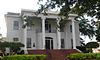 | October 29, 1982 (#82001738) | 605 S. Broadway 32°20′37″N 95°18′04″W / 32.343566°N 95.30108°W / 32.343566; -95.30108 (Ramey House) | Tyler | Recorded Texas Historic Landmark; part of Brick Streets Neighborhood Historic District |
| 23 | Short-Line Residential Historic District |  | August 22, 2002 (#02000897) | Roughly bounded by West Ln., N. Ellis, Short St., and an unnamed alley to the east 32°21′14″N 95°18′26″W / 32.353889°N 95.307222°W / 32.353889; -95.307222 (Short-Line Residential Historic District) | Tyler | Historic and Architectural Resources of Tyler MPS |
| 24 | Smith County Jail, 1881 | 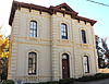 | August 22, 1996 (#96000937) | 309 Erwin St. 32°21′02″N 95°17′53″W / 32.350587°N 95.297999°W / 32.350587; -95.297999 (Smith County Jail, 1881) | Tyler | Recorded Texas Historic Landmark |
| 25 | St. James Colored Methodist Episcopal Church | 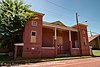 | August 20, 2004 (#04000887) | 408 N. Border Ave. 32°21′15″N 95°18′23″W / 32.35404°N 95.30640°W / 32.35404; -95.30640 (St. James Colored Methodist Episcopal Church) | Tyler | Historic and Architectural Resources of Tyler MPS |
| 26 | St. John's AF & AM Lodge |  | December 6, 2005 (#05001403) | 323 W. Front St. 32°20′50″N 95°18′14″W / 32.34726°N 95.30387°W / 32.34726; -95.30387 (St. John's AF & AM Lodge) | Tyler | |
| 27 | St. Louis Southwestern Railway (Cotton Belt) Passenger Depot | 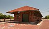 | August 8, 2001 (#01000873) | 100 blk. E. Oakwood St., at N. Spring St. 32°21′17″N 95°17′56″W / 32.35478°N 95.29891°W / 32.35478; -95.29891 (St. Louis Southwestern Railway (Cotton Belt) Passenger Depot) | Tyler | Historic and Architectural Resources of Tyler MPS |
| 28 | Tyler City Hall |  | March 7, 2007 (#07000129) | 212 N. Bonner Ave. 32°21′07″N 95°18′21″W / 32.351944°N 95.305833°W / 32.351944; -95.305833 (Tyler City Hall) | Tyler | Historic and Architectural Resources of Tyler MPS |
| 29 | Tyler Downtown Historic District | Upload image | October 24, 2022 (#100008283) | Roughly bounded by West Front St., Border Ave., Cotton Belt RR tracks, and Fannin Ave. 32°21′03″N 95°18′03″W / 32.3508°N 95.3007°W / 32.3508; -95.3007 (Tyler Downtown Historic District) | Tyler | |
| 30 | Tyler Grocery Company |  | September 14, 2002 (#02000993) | 416 N. Broadway 32°21′15″N 95°18′04″W / 32.354167°N 95.301111°W / 32.354167; -95.301111 (Tyler Grocery Company) | Tyler | Historic and Architectural Resources of Tyler MPS |
| 31 | Tyler Hydraulic-Fill Dam | Upload image | August 29, 1977 (#77001543) | W of Tyler off TX 31 32°19′52″N 95°22′07″W / 32.331111°N 95.368611°W / 32.331111; -95.368611 (Tyler Hydraulic-Fill Dam) | Tyler | State Antiquities Landmark |
| 32 | Tyler Municipal Rose Garden |  | March 22, 2019 (#100003539) | 420 Rose Park Dr. 32°21′07″N 95°18′09″W / 32.35191°N 95.30254°W / 32.35191; -95.30254 (Tyler Municipal Rose Garden) | Tyler | |
| 33 | Tyler US Post Office and Courthouse | 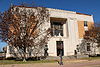 | April 25, 2001 (#01000433) | 211 W. Ferguson St. 32°21′07″N 95°18′09″W / 32.35191°N 95.30254°W / 32.35191; -95.30254 (Tyler US Post Office and Courthouse) | Tyler | |
| 34 | Whitaker-McClendon House | 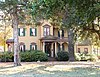 | June 2, 1982 (#82004522) | 806 W. Houston St. 32°20′36″N 95°18′34″W / 32.34334°N 95.30936°W / 32.34334; -95.30936 (Whitaker-McClendon House) | Tyler | Recorded Texas Historic Landmark |
| 35 | Williams-Anderson House |  | September 14, 2002 (#02000995) | 1313 W. Claude St. 32°21′09″N 95°18′54″W / 32.35259°N 95.31511°W / 32.35259; -95.31511 (Williams-Anderson House) | Tyler | Historic and Architectural Resources of Tyler MPS |
See also
 National Register of Historic Places portal
 Texas portal


- National Register of Historic Places listings in Texas
- Recorded Texas Historic Landmarks in Smith County
References
- ^ National Park Service, United States Department of the Interior, "National Register of Historic Places: Weekly List Actions", retrieved July 12, 2024.
- ^ The latitude and longitude information provided in this table was derived originally from the National Register Information System, which has been found to be fairly accurate for about 99% of listings. Some locations in this table may have been corrected to current GPS standards.
- ^ Numbers represent an alphabetical ordering by significant words. Various colorings, defined here, differentiate National Historic Landmarks and historic districts from other NRHP buildings, structures, sites or objects.
- ^ The eight-digit number below each date is the number assigned to each location in the National Register Information System database, which can be viewed by clicking the number.
External links
![]() Media related to National Register of Historic Places in Smith County, Texas at Wikimedia Commons
Media related to National Register of Historic Places in Smith County, Texas at Wikimedia Commons
- v
- t
- e
by county
- Anderson
- Andrews
- Angelina
- Aransas
- Archer
- Armstrong
- Atascosa
- Austin
- Bailey
- Bandera
- Bastrop
- Baylor
- Bee
- Bell
- Bexar
- Blanco
- Borden
- Bosque
- Bowie
- Brazoria
- Brazos
- Brewster
- Briscoe
- Brooks
- Brown
- Burleson
- Burnet
- Caldwell
- Calhoun
- Callahan
- Cameron
- Camp
- Carson
- Cass
- Castro
- Chambers
- Cherokee
- Childress
- Clay
- Cochran
- Coke
- Coleman
- Collin
- Collingsworth
- Colorado
- Comal
- Comanche
- Concho
- Cooke
- Coryell
- Cottle
- Crane
- Crockett
- Crosby
- Culberson
- Dallam
- Dallas
- Dawson
- Deaf Smith
- Delta
- Denton
- DeWitt
- Dickens
- Dimmit
- Donley
- Duval
- Eastland
- Ector
- Edwards
- El Paso
- Ellis
- Erath
- Falls
- Fannin
- Fayette
- Fisher
- Floyd
- Foard
- Fort Bend
- Franklin
- Freestone
- Frio
- Gaines
- Galveston
- Garza
- Gillespie
- Glasscock
- Goliad
- Gonzales
- Gray
- Grayson
- Gregg
- Grimes
- Guadalupe
- Hale
- Hall
- Hamilton
- Hansford
- Hardeman
- Hardin
- Harris
- Harrison
- Hartley
- Haskell
- Hays
- Hemphill
- Henderson
- Hidalgo
- Hill
- Hockley
- Hood
- Hopkins
- Houston
- Howard
- Hudspeth
- Hunt
- Hutchinson
- Irion
- Jack
- Jackson
- Jasper
- Jeff Davis
- Jefferson
- Jim Hogg
- Jim Wells
- Johnson
- Jones
- Karnes
- Kaufman
- Kendall
- Kenedy
- Kent
- Kerr
- Kimble
- King
- Kinney
- Kleberg
- Knox
- La Salle
- Lamar
- Lamb
- Lampasas
- Lavaca
- Lee
- Leon
- Liberty
- Limestone
- Lipscomb
- Live Oak
- Llano
- Loving
- Lubbock
- Lynn
- Madison
- Marion
- Martin
- Mason
- Matagorda
- Maverick
- McCulloch
- McLennan
- McMullen
- Medina
- Menard
- Midland
- Milam
- Mills
- Mitchell
- Montague
- Montgomery
- Moore
- Morris
- Motley
- Nacogdoches
- Navarro
- Newton
- Nolan
- Nueces
- Ochiltree
- Oldham
- Orange
- Palo Pinto
- Panola
- Parker
- Parmer
- Pecos
- Polk
- Potter
- Presidio
- Rains
- Randall
- Reagan
- Real
- Red River
- Reeves
- Refugio
- Roberts
- Robertson
- Rockwall
- Runnels
- Rusk
- Sabine
- San Augustine
- San Jacinto
- San Patricio
- San Saba
- Schleicher
- Scurry
- Shackelford
- Shelby
- Sherman
- Smith
- Somervell
- Starr
- Stephens
- Sterling
- Stonewall
- Sutton
- Swisher
- Tarrant
- Taylor
- Terrell
- Terry
- Throckmorton
- Titus
- Tom Green
- Travis
- Trinity
- Tyler
- Upshur
- Upton
- Uvalde
- Val Verde
- Van Zandt
- Victoria
- Walker
- Waller
- Ward
- Washington
- Webb
- Wharton
- Wheeler
- Wichita
- Wilbarger
- Willacy
- Williamson
- Wilson
- Winkler
- Wise
- Wood
- Yoakum
- Young
- Zapata
- Zavala

Municipalities and communities of Smith County, Texas, United States | ||
|---|---|---|
County seat: Tyler | ||
| Cities | 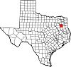 | |
| Towns | ||
| CDP | ||
| Other unincorporated communities |
| |
| Ghost towns | ||
| Footnotes | ‡This populated place also has portions in an adjacent county or counties | |
| ||


