National Register of Historic Places listings in Hidalgo County, Texas

This is a list of the National Register of Historic Places listings in Hidalgo County, Texas
This is intended to be a complete list of properties and districts listed on the National Register of Historic Places in Hidalgo County, Texas. There are four districts and 19 individual properties listed on the National Register in the county. One property is a State Antiquities Landmark. Eight properties are designated Recorded Texas Historic Landmarks (RTHLs) while two districts and two more individual properties contain RTHLs within their boundaries.
This National Park Service list is complete through NPS recent listings posted July 12, 2024.[1]
Current listings
Map all coordinates using OpenStreetMap
Download coordinates as:
- KML
- GPX (all coordinates)
- GPX (primary coordinates)
- GPX (secondary coordinates)
The locations of National Register properties and districts may be seen in a mapping service provided.[2]
| [3] | Name on the Register[4] | Image | Date listed[5] | Location | City or town | Description |
|---|---|---|---|---|---|---|
| 1 | 1910 Hidalgo County Jail |  | May 26, 2020 (#100005230) | 121 East McIntyre St. 26°18′09″N 98°09′42″W / 26.30262°N 98.161787°W / 26.30262; -98.161787 (1910 Hidalgo County Jail) | Edinburg | Recorded Texas Historic Landmark |
| 2 | Border Theater | 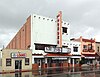 | August 28, 1998 (#98001124) | 905 North Conway Blvd. 26°12′54″N 98°19′33″W / 26.215°N 98.325833°W / 26.215; -98.325833 (Border Theater) | Mission | Recorded Texas Historic Landmark |
| 3 | Casa de Palmas |  | April 18, 2003 (#03000276) | 101 N. Main St. 26°12′17″N 98°14′04″W / 26.2048°N 98.234333°W / 26.2048; -98.234333 (Casa de Palmas) | McAllen | Recorded Texas Historic Landmark |
| 4 | Cine El Rey |  | April 26, 2002 (#02000402) | 311 S. 17th St. 26°12′05″N 98°14′17″W / 26.20147°N 98.23804°W / 26.20147; -98.23804 (Cine El Rey) | McAllen | |
| 5 | Cortez Hotel | 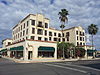 | December 23, 2004 (#04001397) | 260 S. Texas Ave. 26°09′33″N 97°59′27″W / 26.15927°N 97.99091°W / 26.15927; -97.99091 (Cortez Hotel) | Weslaco | Recorded Texas Historic Landmark |
| 6 | El Sal Del Rey Archeological District | Upload image | August 27, 1979 (#79002977) | Address Restricted 26°32′16″N 98°03′24″W / 26.5379°N 98.0566°W / 26.5379; -98.0566 (El Sal Del Rey Archeological District) | Linn | |
| 7 | Mary S. and Gordon Griffin House |  | June 13, 2014 (#14000341) | 704 N. 15th Street 26°12′38″N 98°14′03″W / 26.210669°N 98.234119°W / 26.210669; -98.234119 (Mary S. and Gordon Griffin House) | McAllen | |
| 8 | La Lomita Historic District |  | May 28, 1975 (#75002165) | 5 mi (8.0 km). S of Mission on FM 1016 26°09′12″N 98°19′32″W / 26.15324°N 98.3256°W / 26.15324; -98.3256 (La Lomita Historic District) | Mission | Includes Recorded Texas Historic Landmark |
| 9 | Lomita Boulevard Commercial Historic District |  | September 18, 1998 (#98001184) | 400 to 700 Blocks N. Conway Blvd. 26°12′40″N 98°19′34″W / 26.211111°N 98.326111°W / 26.211111; -98.326111 (Lomita Boulevard Commercial Historic District) | Mission | |
| 10 | Louisiana-Rio Grande Canal Company Irrigation System |  | November 8, 1995 (#95001284) | S. 2nd St. at River Levee 26°05′49″N 98°15′42″W / 26.09689°N 98.26177°W / 26.09689; -98.26177 (Louisiana-Rio Grande Canal Company Irrigation System) | Hidalgo | Address is for First pump station. Listings also includes second pump station in McAllen and approximately 45000 acres of canals in southern Hidalgo County. |
| 11 | M and J Nelson Building |  | October 1, 2008 (#08000962) | 300-308 S. 14th St. 26°12′05″N 98°14′06″W / 26.201428°N 98.234917°W / 26.201428; -98.234917 (M and J Nelson Building) | McAllen | Recorded Texas Historic Landmark |
| 12 | McAllen Ranch | Upload image | April 18, 2007 (#07000337) | FM 1017, 13 mi (21 km). W of TX 281 26°37′25″N 98°18′02″W / 26.62359°N 98.3005°W / 26.62359; -98.3005 (McAllen Ranch) | Linn | |
| 13 | Sam and Marjorie Miller House |  | July 9, 1997 (#97000780) | 707 N. 15th St. 26°12′39″N 98°14′04″W / 26.210833°N 98.234444°W / 26.210833; -98.234444 (Sam and Marjorie Miller House) | McAllen | Recorded Texas Historic Landmark |
| 14 | Mission Canal Company Second Lift Pumphouse |  | August 30, 2002 (#02000910) | 6th St. and Canal 26°12′43″N 98°19′51″W / 26.211944°N 98.330833°W / 26.211944; -98.330833 (Mission Canal Company Second Lift Pumphouse) | Mission | |
| 15 | Mission Citrus Growers Union Packing Shed |  | August 30, 2002 (#02000911) | 824 W. Business TX 83 26°12′56″N 98°19′56″W / 26.215556°N 98.332222°W / 26.215556; -98.332222 (Mission Citrus Growers Union Packing Shed) | Mission | |
| 16 | Oblate Park Historic District |  | December 22, 2005 (#05001459) | Roughly bounded by Doherty, Keralum, W. 16th St. and W 10th St. 26°13′13″N 98°19′17″W / 26.220278°N 98.321389°W / 26.220278; -98.321389 (Oblate Park Historic District) | Mission | Includes Recorded Texas Historic Landmark |
| 17 | Old Hidalgo Courthouse and Buildings |  | February 1, 1980 (#80004136) | Flora and 1st Sts. 26°05′57″N 98°15′44″W / 26.09927°N 98.26212°W / 26.09927; -98.26212 (Old Hidalgo Courthouse and Buildings) | Hidalgo | Includes Recorded Texas Historic Landmarks |
| 18 | Old Hidalgo School |  | October 24, 1979 (#79002976) | Flora and 4th Sts. 26°05′55″N 98°15′35″W / 26.0986°N 98.2597°W / 26.0986; -98.2597 (Old Hidalgo School) | Hidalgo | State Antiquities Landmark |
| 19 | Rancho Toluca | Upload image | July 21, 1983 (#83004513) | FM 1015 26°04′14″N 97°56′43″W / 26.07049°N 97.9454°W / 26.07049; -97.9454 (Rancho Toluca) | Progreso | Includes Recorded Texas Historic Landmarks |
| 20 | Roosevelt School Auditorium and Classroom Addition |  | August 30, 2002 (#02000909) | 407 E. 3rd St. 26°12′30″N 98°19′21″W / 26.20823°N 98.32259°W / 26.20823; -98.32259 (Roosevelt School Auditorium and Classroom Addition) | Mission | |
| 21 | John Shary Building |  | August 30, 2002 (#02000907) | 900 Doherty 26°12′53″N 98°19′28″W / 26.21483°N 98.32443°W / 26.21483; -98.32443 (John Shary Building) | Mission | Recorded Texas Historic Landmark |
| 22 | Teatro La Paz |  | August 30, 2002 (#02000908) | 514,516,518 Doherty 26°12′39″N 98°19′31″W / 26.21095°N 98.32517°W / 26.21095; -98.32517 (Teatro La Paz) | Mission | Recorded Texas Historic Landmark |
| 23 | Valley Fruit Company |  | December 7, 2011 (#11000897) | 724 N. Cage Blvd. 26°12′06″N 98°10′54″W / 26.20172°N 98.18177°W / 26.20172; -98.18177 (Valley Fruit Company) | Pharr |
See also
 National Register of Historic Places portal
 Texas portal


- National Register of Historic Places listings in Texas
- Recorded Texas Historic Landmarks in Hidalgo County
References
- ^ National Park Service, United States Department of the Interior, "National Register of Historic Places: Weekly List Actions", retrieved July 12, 2024.
- ^ The latitude and longitude information provided in this table was derived originally from the National Register Information System, which has been found to be fairly accurate for about 99% of listings. Some locations in this table may have been corrected to current GPS standards.
- ^ Numbers represent an alphabetical ordering by significant words. Various colorings, defined here, differentiate National Historic Landmarks and historic districts from other NRHP buildings, structures, sites or objects.
- ^ "National Register Information System". National Register of Historic Places. National Park Service. July 9, 2010.
- ^ The eight-digit number below each date is the number assigned to each location in the National Register Information System database, which can be viewed by clicking the number.
External links
![]() Media related to National Register of Historic Places in Hidalgo County, Texas at Wikimedia Commons
Media related to National Register of Historic Places in Hidalgo County, Texas at Wikimedia Commons
Places adjacent to National Register of Historic Places listings in Hidalgo County, Texas | ||||||||||||||||
|---|---|---|---|---|---|---|---|---|---|---|---|---|---|---|---|---|
| ||||||||||||||||


- v
- t
- e
by county
- Anderson
- Andrews
- Angelina
- Aransas
- Archer
- Armstrong
- Atascosa
- Austin
- Bailey
- Bandera
- Bastrop
- Baylor
- Bee
- Bell
- Bexar
- Blanco
- Borden
- Bosque
- Bowie
- Brazoria
- Brazos
- Brewster
- Briscoe
- Brooks
- Brown
- Burleson
- Burnet
- Caldwell
- Calhoun
- Callahan
- Cameron
- Camp
- Carson
- Cass
- Castro
- Chambers
- Cherokee
- Childress
- Clay
- Cochran
- Coke
- Coleman
- Collin
- Collingsworth
- Colorado
- Comal
- Comanche
- Concho
- Cooke
- Coryell
- Cottle
- Crane
- Crockett
- Crosby
- Culberson
- Dallam
- Dallas
- Dawson
- Deaf Smith
- Delta
- Denton
- DeWitt
- Dickens
- Dimmit
- Donley
- Duval
- Eastland
- Ector
- Edwards
- El Paso
- Ellis
- Erath
- Falls
- Fannin
- Fayette
- Fisher
- Floyd
- Foard
- Fort Bend
- Franklin
- Freestone
- Frio
- Gaines
- Galveston
- Garza
- Gillespie
- Glasscock
- Goliad
- Gonzales
- Gray
- Grayson
- Gregg
- Grimes
- Guadalupe
- Hale
- Hall
- Hamilton
- Hansford
- Hardeman
- Hardin
- Harris
- Harrison
- Hartley
- Haskell
- Hays
- Hemphill
- Henderson
- Hidalgo
- Hill
- Hockley
- Hood
- Hopkins
- Houston
- Howard
- Hudspeth
- Hunt
- Hutchinson
- Irion
- Jack
- Jackson
- Jasper
- Jeff Davis
- Jefferson
- Jim Hogg
- Jim Wells
- Johnson
- Jones
- Karnes
- Kaufman
- Kendall
- Kenedy
- Kent
- Kerr
- Kimble
- King
- Kinney
- Kleberg
- Knox
- La Salle
- Lamar
- Lamb
- Lampasas
- Lavaca
- Lee
- Leon
- Liberty
- Limestone
- Lipscomb
- Live Oak
- Llano
- Loving
- Lubbock
- Lynn
- Madison
- Marion
- Martin
- Mason
- Matagorda
- Maverick
- McCulloch
- McLennan
- McMullen
- Medina
- Menard
- Midland
- Milam
- Mills
- Mitchell
- Montague
- Montgomery
- Moore
- Morris
- Motley
- Nacogdoches
- Navarro
- Newton
- Nolan
- Nueces
- Ochiltree
- Oldham
- Orange
- Palo Pinto
- Panola
- Parker
- Parmer
- Pecos
- Polk
- Potter
- Presidio
- Rains
- Randall
- Reagan
- Real
- Red River
- Reeves
- Refugio
- Roberts
- Robertson
- Rockwall
- Runnels
- Rusk
- Sabine
- San Augustine
- San Jacinto
- San Patricio
- San Saba
- Schleicher
- Scurry
- Shackelford
- Shelby
- Sherman
- Smith
- Somervell
- Starr
- Stephens
- Sterling
- Stonewall
- Sutton
- Swisher
- Tarrant
- Taylor
- Terrell
- Terry
- Throckmorton
- Titus
- Tom Green
- Travis
- Trinity
- Tyler
- Upshur
- Upton
- Uvalde
- Val Verde
- Van Zandt
- Victoria
- Walker
- Waller
- Ward
- Washington
- Webb
- Wharton
- Wheeler
- Wichita
- Wilbarger
- Willacy
- Williamson
- Wilson
- Winkler
- Wise
- Wood
- Yoakum
- Young
- Zapata
- Zavala

Municipalities and communities of Hidalgo County, Texas, United States | ||
|---|---|---|
County seat: Edinburg | ||
| Cities |  | |
| CDPs |
| |
| Other community | ||
| ||


