National Register of Historic Places listings in Williamson County, Texas

This is a list of the National Register of Historic Places listings in Williamson County, Texas.
This is intended to be a complete list of properties and districts listed on the National Register of Historic Places in Williamson County, Texas. There are eight districts, 66 individual properties, and one former property listed on the National Register in the county. Individually listed properties include one State Antiquities Landmark and 20 Recorded Texas Historic Landmarks while six districts include several more Recorded Texas Historic Landmarks including one that is also a State Antiquities Landmark.
This National Park Service list is complete through NPS recent listings posted July 12, 2024.[1]
Current listings
Map all coordinates using OpenStreetMap
Download coordinates as:
- KML
- GPX (all coordinates)
- GPX (primary coordinates)
- GPX (secondary coordinates)
The publicly disclosed locations of National Register properties and districts may be seen in a mapping service provided.[2]
| [3] | Name on the Register | Image | Date listed[4] | Location | City or town | Description |
|---|---|---|---|---|---|---|
| 1 | Martin C. Amos House |  | April 29, 1986 (#86000989) | 1408 Olive 30°37′53″N 97°40′01″W / 30.631389°N 97.666944°W / 30.631389; -97.666944 (Martin C. Amos House) | Georgetown | Recorded Texas Historic Landmark; part of Olive Street Historic District; Historic Resources of Georgetown MRA |
| 2 | Arnold-Torbet House |  | April 29, 1986 (#86000990) | 908 Pine 30°38′07″N 97°40′13″W / 30.6353°N 97.6702°W / 30.6353; -97.6702 (Arnold-Torbet House) | Georgetown | Historic Resources of Georgetown MRA |
| 3 | Atkinson House |  | April 29, 1986 (#86000992) | 911 Walnut 30°38′08″N 97°40′13″W / 30.635556°N 97.670278°W / 30.635556; -97.670278 (Atkinson House) | Georgetown | Recorded Texas Historic Landmark; Historic Resources of Georgetown MRA |
| 4 | Bartlett Commercial Historic District |  | September 30, 1980 (#80004076) | E. Clark St. 30°47′42″N 97°25′37″W / 30.795°N 97.426944°W / 30.795; -97.426944 (Bartlett Commercial Historic District) | Bartlett | Extends into Bell County |
| 5 | Belford Historic District |  | April 29, 1986 (#86000991) | Roughly bounded by University Ave., Main, E. Eighteenth, and Austin 30°37′48″N 97°40′39″W / 30.63°N 97.6775°W / 30.63; -97.6775 (Belford Historic District) | Georgetown | Includes Recorded Texas Historic Landmarks; Historic Resources of Georgetown MRA |
| 6 | Bowlen House | Upload image | January 14, 1986 (#86000180) | 1405 Forest 30°37′53″N 97°40′44″W / 30.631389°N 97.678889°W / 30.631389; -97.678889 (Bowlen House) | Georgetown | Historic Resources of Georgetown MRA; house no longer present |
| 7 | Bryson Stage Coach Stop |  | December 1, 1978 (#78003000) | Northwest of Liberty Hill on TX 29 30°40′40″N 97°56′37″W / 30.677778°N 97.943611°W / 30.677778; -97.943611 (Bryson Stage Coach Stop) | Liberty Hill | Recorded Texas Historic Landmark |
| 8 | Burcham House |  | April 29, 1986 (#86000993) | 1310 College 30°37′54″N 97°40′19″W / 30.631667°N 97.671944°W / 30.631667; -97.671944 (Burcham House) | Georgetown | Recorded Texas Historic Landmark; Historic Resources of Georgetown MRA |
| 9 | Casey House |  | January 14, 1986 (#86000184) | 705 E. Third 30°38′27″N 97°40′12″W / 30.640833°N 97.67°W / 30.640833; -97.67 (Casey House) | Georgetown | Historic Resources of Georgetown MRA |
| 10 | Caswell House |  | April 29, 1986 (#86000994) | 207 E. Ninth 30°38′09″N 97°40′31″W / 30.635833°N 97.675278°W / 30.635833; -97.675278 (Caswell House) | Georgetown | Historic Resources of Georgetown MRA |
| 11 | Chesser-Morgan House |  | January 14, 1986 (#86000185) | 1202 E. Fifteenth 30°37′49″N 97°39′56″W / 30.630278°N 97.665556°W / 30.630278; -97.665556 (Chesser-Morgan House) | Georgetown | Part of Olive Street Historic District; Historic Resources of Georgetown MRA |
| 12 | Jesse and Sara Cooper House |  | February 16, 1996 (#96000073) | 1.8 mi (2.9 km). east of Georgetown Hwy. 29 30°38′32″N 97°38′48″W / 30.642222°N 97.646667°W / 30.642222; -97.646667 (Jesse and Sara Cooper House) | Georgetown | Recorded Texas Historic Landmark; Historic Resources of Georgetown MRA |
| 13 | E. M. Daughtrey House | Upload image | April 29, 1986 (#86000984) | 1316 E. University 30°37′58″N 97°39′47″W / 30.632778°N 97.663056°W / 30.632778; -97.663056 (E. M. Daughtrey House) | Georgetown | Historic Resources of Georgetown MRA Moved or demolished |
| 14 | Dr. James L. Dickey House | 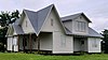 | February 21, 2017 (#100000675) | 500 Burkett Rd. 30°34′20″N 97°24′18″W / 30.572142°N 97.405059°W / 30.572142; -97.405059 (Dr. James L. Dickey House) | Taylor | Destroyed by fire July 10, 2022 |
| 15 | John J. Dimmitt House | 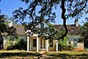 | February 16, 1996 (#96000076) | W. University (TX 29) 0.5 mi. west of the junction with Austin Highway. 30°38′05″N 97°41′12″W / 30.6347°N 97.6867°W / 30.6347; -97.6867 (John J. Dimmitt House) | Georgetown | Recorded Texas Historic Landmark; Historic Resources of Georgetown MRA |
| 16 | S. A. Easley House |  | April 29, 1986 (#86000983) | 1310 Olive 30°37′55″N 97°40′02″W / 30.6319°N 97.6673°W / 30.6319; -97.6673 (S. A. Easley House) | Georgetown | Recorded Texas Historic Landmark; part of Olive Street Historic District; Historic Resources of Georgetown MRA |
| 17 | First Methodist Church | 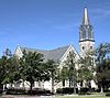 | June 17, 1986 (#86001368) | 410 E. University 30°37′58″N 97°40′23″W / 30.632778°N 97.673056°W / 30.632778; -97.673056 (First Methodist Church) | Georgetown | Recorded Texas Historic Landmark; Historic Resources of Georgetown MRA |
| 18 | D. D. Fowler House | 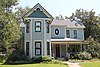 | April 29, 1986 (#86000985) | 1531 Ash 30°37′45″N 97°40′21″W / 30.629167°N 97.6725°W / 30.629167; -97.6725 (D. D. Fowler House) | Georgetown | Historic Resources of Georgetown MRA |
| 19 | Georgetown Light and Water Works |  | February 16, 1996 (#96000074) | 403 W. 9th 30°38′10″N 97°40′49″W / 30.636111°N 97.680278°W / 30.636111; -97.680278 (Georgetown Light and Water Works) | Georgetown | Historic Resources of Georgetown MRA |
| 20 | Harper-Chesser House |  | April 29, 1986 (#86000969) | 1309 College 30°37′54″N 97°40′17″W / 30.631667°N 97.671389°W / 30.631667; -97.671389 (Harper-Chesser House) | Georgetown | Historic Resources of Georgetown MRA |
| 21 | Moses Harrell House |  | January 14, 1986 (#86000169) | 1001 Church 30°38′04″N 97°40′32″W / 30.634444°N 97.675556°W / 30.634444; -97.675556 (Moses Harrell House) | Georgetown | Historic Resources of Georgetown MRA |
| 22 | E. M. Harris House |  | January 14, 1986 (#86000168) | 404 E. Seventh 30°38′13″N 97°40′24″W / 30.636944°N 97.673333°W / 30.636944; -97.673333 (E. M. Harris House) | Georgetown | Historic Resources of Georgetown MRA |
| 23 | A. W. Hawnen House |  | April 29, 1986 (#86000967) | 1409 Olive 30°37′54″N 97°39′59″W / 30.631667°N 97.666389°W / 30.631667; -97.666389 (A. W. Hawnen House) | Georgetown | Part of Olive Street Historic District; Historic Resources of Georgetown MRA |
| 24 | M. S. Hewitt House |  | February 16, 1996 (#96000071) | 1019 S. College 30°38′01″N 97°40′24″W / 30.633611°N 97.673333°W / 30.633611; -97.673333 (M. S. Hewitt House) | Georgetown | Historic Resources of Georgetown MRA |
| 25 | House at 214 W. University |  | April 29, 1986 (#86000987) | 214 W. University 30°37′58″N 97°40′41″W / 30.632778°N 97.678056°W / 30.632778; -97.678056 (House at 214 W. University) | Georgetown | Historic Resources of Georgetown MRA |
| 26 | House at 801 West |  | January 14, 1986 (#86000172) | 801 West 30°38′10″N 97°40′52″W / 30.636111°N 97.681111°W / 30.636111; -97.681111 (House at 801 West) | Georgetown | Historic Resources of Georgetown MRA |
| 27 | House at 907 Pine |  | January 14, 1986 (#86000171) | 907 Pine 30°38′09″N 97°40′11″W / 30.6359°N 97.6697°W / 30.6359; -97.6697 (House at 907 Pine) | Georgetown | Historic Resources of Georgetown MRA |
| 28 | Hutto Commercial Historic District |  | August 4, 2011 (#11000515) | 101-205 East St., 202 Farley St. & 204 US 79 30°32′38″N 97°31′50″W / 30.543889°N 97.530556°W / 30.543889; -97.530556 (Hutto Commercial Historic District) | Hutto | |
| 29 | Dr. Robert Hyer House |  | January 14, 1986 (#86000175) | 904 Ash 30°38′07″N 97°40′23″W / 30.635278°N 97.673056°W / 30.635278; -97.673056 (Dr. Robert Hyer House) | Georgetown | Historic Resources of Georgetown MRA |
| 30 | Imhoff House |  | January 14, 1986 (#86000176) | 208 Austin 30°38′27″N 97°40′41″W / 30.640833°N 97.678056°W / 30.640833; -97.678056 (Imhoff House) | Georgetown | Historic Resources of Georgetown MRA |
| 31 | Inn at Brushy Creek |  | October 15, 1970 (#70000777) | Taylor Exit off U.S. 79, off I-35 30°30′57″N 97°41′22″W / 30.5159°N 97.6894°W / 30.5159; -97.6894 (Inn at Brushy Creek) | Round Rock | |
| 32 | George Irvine House |  | April 29, 1986 (#86000973) | 409 E. University 30°38′00″N 97°40′24″W / 30.633333°N 97.673333°W / 30.633333; -97.673333 (George Irvine House) | Georgetown | Recorded Texas Historic Landmark; Historic Resources of Georgetown MRA |
| 33 | J. J. Johnson Farm | Upload image | January 14, 1986 (#86000178) | Rabbitt Hill Rd. 30°34′59″N 97°40′18″W / 30.583056°N 97.671667°W / 30.583056; -97.671667 (J. J. Johnson Farm) | Georgetown | Historic Resources of Georgetown MRA; house no longer present |
| 34 | Kenney's Fort Site (41WM465) |  | April 20, 1987 (#87000565) | Address restricted[5] | Round Rock | |
| 35 | Lane-Riley House |  | April 29, 1986 (#86000975) | 1302 College 30°37′55″N 97°40′19″W / 30.631944°N 97.671944°W / 30.631944; -97.671944 (Lane-Riley House) | Georgetown | Recorded Texas Historic Landmark; Historic Resources of Georgetown MRA |
| 36 | Will and Mary Leake House |  | April 29, 1986 (#86000976) | 313 E. Seventh 30°38′14″N 97°40′26″W / 30.637222°N 97.673889°W / 30.637222; -97.673889 (Will and Mary Leake House) | Georgetown | Historic Resources of Georgetown MRA |
| 37 | John Leavell House |  | April 29, 1986 (#86000979) | 803 College 30°38′12″N 97°40′18″W / 30.636653°N 97.671552°W / 30.636653; -97.671552 (John Leavell House) | Georgetown | Historic Resources of Georgetown MRA |
| 38 | M. B. and Annie Lockett House |  | April 29, 1986 (#86000981) | 811 E. University 30°38′00″N 97°40′08″W / 30.633333°N 97.668889°W / 30.633333; -97.668889 (M. B. and Annie Lockett House) | Georgetown | Historic Resources of Georgetown MRA |
| 39 | Frank and Mellie Love House |  | April 29, 1986 (#86000977) | 1415 Ash 30°37′50″N 97°40′20″W / 30.630556°N 97.672222°W / 30.630556; -97.672222 (Frank and Mellie Love House) | Georgetown | Historic Resources of Georgetown MRA |
| 40 | W. K. and Kate Makemson House |  | January 14, 1986 (#86000190) | 1002 Ash 30°38′04″N 97°40′23″W / 30.634444°N 97.673056°W / 30.634444; -97.673056 (W. K. and Kate Makemson House) | Georgetown | Historic Resources of Georgetown MRA |
| 41 | McFadin House |  | April 9, 1980 (#80004160) | North of Taylor 30°38′18″N 97°25′33″W / 30.638333°N 97.425833°W / 30.638333; -97.425833 (McFadin House) | Taylor | Recorded Texas Historic Landmark |
| 42 | McKnight-Ebb House | Upload image | January 14, 1986 (#86000191) | 502 W. Eighteenth 30°37′34″N 97°40′53″W / 30.626111°N 97.681389°W / 30.626111; -97.681389 (McKnight-Ebb House) | Georgetown | Historic Resources of Georgetown MRA Moved or demolished |
| 43 | McMurray House |  | January 14, 1986 (#86000192) | 611 Church 30°38′13″N 97°40′30″W / 30.636944°N 97.675°W / 30.636944; -97.675 (McMurray House) | Georgetown | Historic Resources of Georgetown MRA |
| 44 | Capt. Nelson Merrell House |  | October 15, 1970 (#70000778) | Northeast of Round Rock on U.S. 79 30°31′02″N 97°39′41″W / 30.517222°N 97.661389°W / 30.517222; -97.661389 (Capt. Nelson Merrell House) | Round Rock | |
| 45 | Miller-Ellyson House |  | January 14, 1986 (#86000193) | 303 E. Ninth 30°38′09″N 97°40′28″W / 30.635833°N 97.674444°W / 30.635833; -97.674444 (Miller-Ellyson House) | Georgetown | Historic Resources of Georgetown MRA |
| 46 | Old Georgetown High School |  | January 14, 1986 (#86000195) | 507 E. University 30°38′01″N 97°40′20″W / 30.633611°N 97.672222°W / 30.633611; -97.672222 (Old Georgetown High School) | Georgetown | Recorded Texas Historic Landmark; Historic Resources of Georgetown MRA |
| 47 | Olive Street Historic District |  | August 20, 2013 (#13000615) | Olive St. between E. University Ave. & 17th St. plus a portion of E. 15th St. 30°37′51″N 97°40′01″W / 30.63084°N 97.6670°W / 30.63084; -97.6670 (Olive Street Historic District) | Georgetown | Includes Recorded Texas Historic Landmarks; Historic Resources of Georgetown MRA |
| 48 | Paige-DeCrow-Weir House |  | January 14, 1986 (#86000194) | I-35 and State Route 2243 30°37′24″N 97°41′30″W / 30.623333°N 97.691667°W / 30.623333; -97.691667 (Paige-DeCrow-Weir House) | Georgetown | Recorded Texas Historic Landmark; Historic Resources of Georgetown MRA |
| 49 | Woodson and Margaret Patrick House |  | January 14, 1986 (#86000197) | 211 E. Fifth 30°38′21″N 97°40′31″W / 30.639167°N 97.675278°W / 30.639167; -97.675278 (Woodson and Margaret Patrick House) | Georgetown | Historic Resources of Georgetown MRA |
| 50 | Pegues House |  | January 14, 1986 (#86000196) | 904 E. University 30°37′59″N 97°40′07″W / 30.6330°N 97.6687°W / 30.6330; -97.6687 (Pegues House) | Georgetown | Historic Resources of Georgetown MRA |
| 51 | Preslar-Hewitt Building |  | May 1, 2003 (#03000331) | 321-323 N. Main 30°34′13″N 97°24′35″W / 30.570278°N 97.409722°W / 30.570278; -97.409722 (Preslar-Hewitt Building) | Taylor | Recorded Texas Historic Landmark; part of Taylor Downtown Historic District |
| 52 | R. H. and Martha Price House |  | April 29, 1986 (#86000982) | 209 E. Tenth 30°38′05″N 97°40′31″W / 30.634722°N 97.675278°W / 30.634722; -97.675278 (R. H. and Martha Price House) | Georgetown | Historic Resources of Georgetown MRA |
| 53 | Railroad Produce Depot |  | November 7, 1979 (#79003024) | 401 W. 6th St. 30°38′18″N 97°40′49″W / 30.638333°N 97.680278°W / 30.638333; -97.680278 (Railroad Produce Depot) | Georgetown | State Antiquities Landmark |
| 54 | J. H. Reedy House |  | April 29, 1986 (#86000949) | 908 E. University 30°37′59″N 97°40′06″W / 30.6330°N 97.6682°W / 30.6330; -97.6682 (J. H. Reedy House) | Georgetown | Historic Resources of Georgetown MRA |
| 55 | Round Rock Commercial Historic District |  | June 9, 1983 (#83003170) | 100 and 200 blocks of E. Main St. 30°30′30″N 97°40′39″W / 30.508333°N 97.6775°W / 30.508333; -97.6775 (Round Rock Commercial Historic District) | Round Rock | Includes Recorded Texas Historic Landmarks |
| 56 | Round Rock Post Office and William M. Owen House |  | July 7, 1983 (#83003171) | Chisholm Trail and Emanuel St. 30°30′55″N 97°41′24″W / 30.515278°N 97.69°W / 30.515278; -97.69 (Round Rock Post Office and William M. Owen House) | Round Rock | Recorded Texas Historic Landmark |
| 57 | Rouser House |  | January 14, 1986 (#86000198) | 602 Myrtle 30°38′16″N 97°40′30″W / 30.637778°N 97.675°W / 30.637778; -97.675 (Rouser House) | Georgetown | Historic Resources of Georgetown MRA |
| 58 | Saint John's Methodist Church |  | April 29, 1986 (#86000950) | 301 E University Ave 30°38′01″N 97°40′29″W / 30.633611°N 97.674722°W / 30.633611; -97.674722 (Saint John's Methodist Church) | Georgetown | Historic Resources of Georgetown MRA |
| 59 | Sansom-Schmalenbeck House | Upload image | January 14, 1986 (#86000199) | 813 Church 30°38′09″N 97°40′32″W / 30.635833°N 97.675556°W / 30.635833; -97.675556 (Sansom-Schmalenbeck House) | Georgetown | Historic Resources of Georgetown MRA Demolished or moved |
| 60 | Saxon Motor Car Store |  | June 17, 1986 (#86001366) | 316 E. Sixth St. 30°38′17″N 97°40′27″W / 30.638056°N 97.674167°W / 30.638056; -97.674167 (Saxon Motor Car Store) | Georgetown | Historic Resources of Georgetown MRA |
| 61 | A. W. Sillure House |  | April 29, 1986 (#86000951) | 1414 Ash 30°37′50″N 97°40′23″W / 30.630556°N 97.673056°W / 30.630556; -97.673056 (A. W. Sillure House) | Georgetown | Recorded Texas Historic Landmark; Historic Resources of Georgetown MRA |
| 62 | Southwestern University Administration Building and Mood Hall |  | April 23, 1975 (#75002013) | 1001 E. University Ave., Southwestern University campus 30°38′00″N 97°40′01″W / 30.633333°N 97.666944°W / 30.633333; -97.666944 (Southwestern University Administration Building and Mood Hall) | Georgetown | Recorded Texas Historic Landmark |
| 63 | Robert and Lula Stone House |  | January 14, 1986 (#86000200) | 1102 Ash 30°38′01″N 97°40′23″W / 30.633611°N 97.673056°W / 30.633611; -97.673056 (Robert and Lula Stone House) | Georgetown | Historic Resources of Georgetown MRA |
| 64 | Taylor Downtown Historic District |  | October 26, 2005 (#05001193) | Roughly bounded by 5th, Washburn, 1st & Vance Sts. 30°34′16″N 97°24′36″W / 30.571111°N 97.41°W / 30.571111; -97.41 (Taylor Downtown Historic District) | Taylor | Includes Recorded Texas Historic Landmarks |
| 65 | Taylor High School Campus |  | May 17, 2018 (#100002437) | 410 W. 7th St. 30°34′07″N 97°24′51″W / 30.568611°N 97.414080°W / 30.568611; -97.414080 (Taylor High School Campus) | Taylor | |
| 66 | Taylor National Bank |  | May 23, 1980 (#80004159) | 200 Main St. 30°34′07″N 97°24′33″W / 30.568611°N 97.409167°W / 30.568611; -97.409167 (Taylor National Bank) | Taylor | Recorded Texas Historic Landmark; part of Taylor Downtown Historic District |
| 67 | Taylor-Cooper House |  | January 14, 1986 (#86000203) | 105 E 5th 30°38′22″N 97°40′36″W / 30.639444°N 97.676667°W / 30.639444; -97.676667 (Taylor-Cooper House) | Georgetown | Historic Resources of Georgetown MRA |
| 68 | Tinnen House |  | August 25, 1970 (#70000776) | 1220 Austin St. 30°37′53″N 97°40′37″W / 30.631389°N 97.676944°W / 30.631389; -97.676944 (Tinnen House) | Georgetown | Part of Belford Historic District |
| 69 | University Avenue-Elm Street Historic District |  | December 6, 1979 (#79003025) | E. University and Elm Sts. 30°37′44″N 97°40′18″W / 30.628889°N 97.671667°W / 30.628889; -97.671667 (University Avenue-Elm Street Historic District) | Georgetown | Includes Recorded Texas Historic Landmarks |
| 70 | W. C. and Kate Vaden House |  | April 29, 1986 (#86000952) | 711 E. University 30°38′01″N 97°40′13″W / 30.63358°N 97.67024°W / 30.63358; -97.67024 (W. C. and Kate Vaden House) | Georgetown | Recorded Texas Historic Landmark; Historic Resources of Georgetown MRA |
| 71 | Wesley Chapel A.M.E Church |  | January 14, 1986 (#86000204) | 508 W. Fourth 30°38′24″N 97°40′53″W / 30.64°N 97.681389°W / 30.64; -97.681389 (Wesley Chapel A.M.E Church) | Georgetown | Recorded Texas Historic Landmark; Historic Resources of Georgetown MRA |
| 72 | D. K. and Inez Wilcox House |  | April 29, 1986 (#86000954) | 1307 Olive 30°37′55″N 97°40′00″W / 30.6319°N 97.6667°W / 30.6319; -97.6667 (D. K. and Inez Wilcox House) | Georgetown | Part of Olive Street Historic District; Historic Resources of Georgetown MRA |
| 73 | Wilcox-Graves House |  | April 29, 1986 (#86000953) | 1403 Olive 30°37′55″N 97°39′59″W / 30.631944°N 97.666389°W / 30.631944; -97.666389 (Wilcox-Graves House) | Georgetown | Part of Olive Street Historic District; Historic Resources of Georgetown MRA |
| 74 | Williamson County Courthouse Historic District |  | July 26, 1977 (#77001480) April 29, 1986 boundary increase (#86000955) | Rock and 9th Sts., Main and 7th Sts. (includes both sides) 30°38′12″N 97°40′39″W / 30.636667°N 97.6775°W / 30.636667; -97.6775 (Williamson County Courthouse Historic District) | Georgetown | Includes State Antiquities Landmark, Recorded Texas Historic Landmarks; Historic Resources of Georgetown MRA (boundary increase) |
| 75 | Zidell House |  | May 12, 2009 (#09000308) | 2015 W. Lake Dr. 30°34′33″N 97°25′53″W / 30.575811°N 97.431417°W / 30.575811; -97.431417 (Zidell House) | Taylor |
Former listings
| [3] | Name on the Register | Image | Date listed | Date removed | Location | City or town | Description |
|---|---|---|---|---|---|---|---|
| 1 | Grace Episcopal Church |  | April 29, 1986 (#86000986) | February 17, 1999 | 811 S. Main St. 30°38′09″N 97°40′36″W / 30.635911°N 97.676737°W / 30.635911; -97.676737 (Grace Episcopal Church) | Georgetown | Historic Resources of Georgetown MRA; formerly located at 1314 E University while NRHP-listed |
See also
 National Register of Historic Places portal
 Texas portal


- National Register of Historic Places listings in Texas
- Recorded Texas Historic Landmarks in Williamson County
References
- ^ National Park Service, United States Department of the Interior, "National Register of Historic Places: Weekly List Actions", retrieved July 12, 2024.
- ^ The latitude and longitude information provided in this table was derived originally from the National Register Information System, which has been found to be fairly accurate for about 99% of listings. Some locations in this table may have been corrected to current GPS standards.
- ^ a b Numbers represent an alphabetical ordering by significant words. Various colorings, defined here, differentiate National Historic Landmarks and historic districts from other NRHP buildings, structures, sites or objects.
- ^ The eight-digit number below each date is the number assigned to each location in the National Register Information System database, which can be viewed by clicking the number.
- ^ Federal and state laws and practices restrict general public access to information regarding the specific location of this resource. In some cases, this is to protect archeological sites from vandalism, while in other cases it is restricted at the request of the owner. See: Knoerl, John; Miller, Diane; Shrimpton, Rebecca H. (1990), Guidelines for Restricting Information about Historic and Prehistoric Resources, National Register Bulletin, National Park Service, U.S. Department of the Interior, OCLC 20706997.
External links
 Media related to National Register of Historic Places in Williamson County, Texas at Wikimedia Commons
Places adjacent to National Register of Historic Places listings in Williamson County, Texas | ||||||||||||||||
|---|---|---|---|---|---|---|---|---|---|---|---|---|---|---|---|---|
| ||||||||||||||||


- v
- t
- e
by county
- Anderson
- Andrews
- Angelina
- Aransas
- Archer
- Armstrong
- Atascosa
- Austin
- Bailey
- Bandera
- Bastrop
- Baylor
- Bee
- Bell
- Bexar
- Blanco
- Borden
- Bosque
- Bowie
- Brazoria
- Brazos
- Brewster
- Briscoe
- Brooks
- Brown
- Burleson
- Burnet
- Caldwell
- Calhoun
- Callahan
- Cameron
- Camp
- Carson
- Cass
- Castro
- Chambers
- Cherokee
- Childress
- Clay
- Cochran
- Coke
- Coleman
- Collin
- Collingsworth
- Colorado
- Comal
- Comanche
- Concho
- Cooke
- Coryell
- Cottle
- Crane
- Crockett
- Crosby
- Culberson
- Dallam
- Dallas
- Dawson
- Deaf Smith
- Delta
- Denton
- DeWitt
- Dickens
- Dimmit
- Donley
- Duval
- Eastland
- Ector
- Edwards
- El Paso
- Ellis
- Erath
- Falls
- Fannin
- Fayette
- Fisher
- Floyd
- Foard
- Fort Bend
- Franklin
- Freestone
- Frio
- Gaines
- Galveston
- Garza
- Gillespie
- Glasscock
- Goliad
- Gonzales
- Gray
- Grayson
- Gregg
- Grimes
- Guadalupe
- Hale
- Hall
- Hamilton
- Hansford
- Hardeman
- Hardin
- Harris
- Harrison
- Hartley
- Haskell
- Hays
- Hemphill
- Henderson
- Hidalgo
- Hill
- Hockley
- Hood
- Hopkins
- Houston
- Howard
- Hudspeth
- Hunt
- Hutchinson
- Irion
- Jack
- Jackson
- Jasper
- Jeff Davis
- Jefferson
- Jim Hogg
- Jim Wells
- Johnson
- Jones
- Karnes
- Kaufman
- Kendall
- Kenedy
- Kent
- Kerr
- Kimble
- King
- Kinney
- Kleberg
- Knox
- La Salle
- Lamar
- Lamb
- Lampasas
- Lavaca
- Lee
- Leon
- Liberty
- Limestone
- Lipscomb
- Live Oak
- Llano
- Loving
- Lubbock
- Lynn
- Madison
- Marion
- Martin
- Mason
- Matagorda
- Maverick
- McCulloch
- McLennan
- McMullen
- Medina
- Menard
- Midland
- Milam
- Mills
- Mitchell
- Montague
- Montgomery
- Moore
- Morris
- Motley
- Nacogdoches
- Navarro
- Newton
- Nolan
- Nueces
- Ochiltree
- Oldham
- Orange
- Palo Pinto
- Panola
- Parker
- Parmer
- Pecos
- Polk
- Potter
- Presidio
- Rains
- Randall
- Reagan
- Real
- Red River
- Reeves
- Refugio
- Roberts
- Robertson
- Rockwall
- Runnels
- Rusk
- Sabine
- San Augustine
- San Jacinto
- San Patricio
- San Saba
- Schleicher
- Scurry
- Shackelford
- Shelby
- Sherman
- Smith
- Somervell
- Starr
- Stephens
- Sterling
- Stonewall
- Sutton
- Swisher
- Tarrant
- Taylor
- Terrell
- Terry
- Throckmorton
- Titus
- Tom Green
- Travis
- Trinity
- Tyler
- Upshur
- Upton
- Uvalde
- Val Verde
- Van Zandt
- Victoria
- Walker
- Waller
- Ward
- Washington
- Webb
- Wharton
- Wheeler
- Wichita
- Wilbarger
- Willacy
- Williamson
- Wilson
- Winkler
- Wise
- Wood
- Yoakum
- Young
- Zapata
- Zavala

Municipalities and communities of Williamson County, Texas, United States | ||
|---|---|---|
County seat: Georgetown | ||
| Cities |  | |
| CDPs |
| |
| Other communities | ||
| Ghost town | ||
| Footnotes | ‡This populated place also has portions in an adjacent county or counties | |
| ||


